Click here for more info on on SMS!

K4Y4

LAKES OF THE NORTH
GAYLORD
MI
Time Zone: Eastern
Lat: N 4454.7
Long: W 08452.5
Elev: 1287
Var: +05
Longest Runway: 4212
CTAF: 122.9

FBO & Flight Services info for K4Y4

FBOs: Update your Fuel Prices

AIRPORTPh: 231-585-6000
-
Freq: 122.9
Service
Jet
100LL
SAF
MoGas
Fuel Avail: NO FUEL AVAILABLE
Full        Last Update: 04/19/2024 00:01:45

Self        
If you are an FBO, call 1-203-262-1700 to update your info or email: FltPlan.Advertising@garmin.com
Advertise your FBO on FltPlan.com

Runway & Approach Info for K4Y4
Rwy
Length
Land Dist**
Approach*
  Rwy
Length
Land Dist**
Approach*
06
4212x40  4212'          
 
  
24
  4212x40  4212'          
 
 * only ILS, LOC, LDA, and SDF approaches to a specific runway are shown
** For any Declared Landing Distance Available, please see A/FD or Approach plates
Runway Weight Capability (lbs.) Help
Runway IDSingle WheelDouble WheelDouble Tandem WheelDual Double Wheel
06/24N/AN/AN/AN/A
These numbers are Advisory and are not limits.   The Airport Manager should have more accurate Weight Limits
Approach Charts
FltPlan does not have IFR approach charts available for K4Y4.
Current Weather/Notams
Customs Information Send updates to Support@FltPlan.com
Customs Not Available
Database effective 04/18/2024
Airport Diagram of K4Y4
Airport Diagram might not be current.

Facility Name: LAKES OF THE NORTH
City Name: GAYLORD
County: ANTRIM
State abbrev: MI
State Name: MICHIGAN
   
Ownership: PRIVATELY OWNED
Use: OPEN TO THE PUBLIC
Owner's Name: LAKES OF THE NORTH ASSN
Address: 5950 SKYTRAILS CT
 MANCELONA, MI 49659-9174
Owner's Phone: 231-585-6000
  
Manager's Name: DARYN HOOGERHYDE
Address: 5950 SKYTRAILS CT
 MANCELONA, MI 49659-9174
Phone: 231-585-6000
   
FAA Region: GREAT LAKES
FAA Field Office: DET


Sunrise / Sunset times for LAKES OF THE NORTH

DateSunriseSunset
04/19/24 Friday6:4720:31
04/20/24 Saturday6:4520:32
04/21/24 Sunday6:4320:33
04/22/24 Monday6:4220:35
04/23/24 Tuesday6:4020:36
04/24/24 Wednesday6:3920:37
04/25/24 Thursday6:3720:38
04/26/24 Friday6:3520:40
04/27/24 Saturday6:3420:41
04/28/24 Sunday6:3220:42
04/29/24 Monday6:3120:43
04/30/24 Tuesday6:2920:45
05/01/24 Wednesday6:2820:46
05/02/24 Thursday6:2620:47

Airport Facilities

Airport Attendance ScheduleMON-FRI 0900-1700, SAT 0900-1300
Airport Status OPERATIONAL (This Status can change at any time - please check NOTAMS)
Airport Lighting ScheduleACTVT LIRL RWY 06/24 - CTAF.
Airport Storage AvailableTie Downs
Extra Services AvailableNONE
Wind IndicatorYES - (lighted)
Control TowerNO
CTAF Frequency122.900
Unicom Frequency
Rotating Beacon ColorWG
Segmented CircleNO
Landing FeeNO

Airport Inspection Data

Airport InspectedSTATE - performed by STATE AERONAUTICAL PERSONNEL
Inspection Date06/14/2022

Airport Services

Type of Fuel AvailableNone
Airframe Repair ServiceNONE
Power Plant Repair ServiceNONE

Geographic Data

LatitudeN4454.7
LongitudeW08452.5 (ESTIMATED)
Arpt Elevation1287ft (SURVEYED)
Magnetic Variation05W
11 miles SWof GAYLORD
Traffic Pattern Altitude
Sectional ChartLAKE HURON

Aircraft Data

Operations (Reported)YearlyAvg. Daily
General Aviation Transient 10003
General Aviation Local 10003
Air Taxi 00
Commerical 00
Commuter 00
Military 00
Aircraft based on Field
General Aviation Singles 8
General Aviation Multi 1
Jet Aircraft 0
General Aviation Helicopters 0
Military Aircraft 0
Gliders 0
Ultralights 0

FAA Services

FSS on field NO
FSS tie-in LANSING
FSS Phone 1-800-WX-BRIEF
Who issues Notams LAN
Notam D service at airport YES
ARTCC Name MINNEAPOLIS

Federal Status

Airport Certification
Aircraft Rescue & Firefighting IndexNone
Airport of EntryNo
Custom Landing RightsNo
Joint Civil/MilitaryNo
Military Landing rightsNo

Remarks

DEER & LRG BIRDS ON & INVOF ARPT.
RWY UPSLOPE FM EAST TO WEST, APRXLY 20 FT HYR ON WEST END.
GOLF CRS & RESTAURANT ADJ.
UAS OPS INVOF ARPT.
FOR CD CTC MINNEAPOLIS ARTCC AT 651-463-5588.
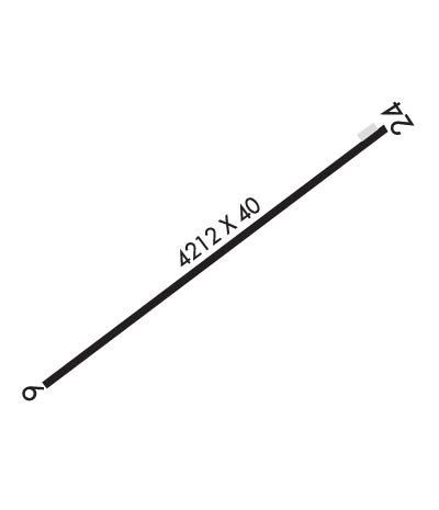
Runway Identifications
Runway Identification: 06/24
Length: 4212 ft
Width: 40 ft
Surface: ASPHALT-GOOD CONDITION
Edge lights: Low Intensity

Treatment: NONE

 Runway: 06   Runway: 24
Mag heading: 56°Mag heading: 236°
Rwy Slope: -.24% DownRwy Slope: .24% Up
Approach: Approach:
Pattern: Left TrafficPattern: Left Traffic
Markings: BASICMarkings: BASIC
Marking Condition: GOODMarking Condition: GOOD
Arresting Dev: Arresting Dev:
Lat & Long: N4454.5  W08452.9Lat. & Long.: N4454.9  W08452.1
Elev: 1285.8 ft. MSLElev: 1275.5 ft. MSL
TCH: TCH:
Visual Glide Path: Visual Glide Path:
Displaced Threshold: NoDisplaced Threshold: No
Touchdown Zone: NOTouchdown Zone: NO
Touchdown Elev.: Touchdown Elev.:
Visual Glide Slope: Visual Glide Slope:
RVR Equipment: RVR Equipment:
RVV Equipment: NORVV Equipment: NO
Approach Lights: Approach Lights:
REIL: NOREIL: NO
Centerline Lights: NOCenterline Lights: NO
Touchdown lights: NOTouchdown lights: NO
Runway Category: Runway with a Visual ApproachRunway Category: Runway with a Visual Approach
Declared Distances: Declared Distances:
Obstructions: ROADObstructions: FENCE
Marked: NOT Marked/LightedMarked: NOT Marked/Lighted
Clearance slope: 6:1Clearance slope: 1:1
Obstruction height: 4 feet AGLObstruction height: 4 feet AGL
Dist. from runway: 224 feetDist. from runway: 201 feet
Centerline offset: 125 right of centerlineCenterline offset: 123 feet left of centerline
Comments: Comments:
C:/P: