Click here for more info on on SMS!

K4V8

MOUNT SNOW
WEST DOVER
VT
Time Zone: Eastern
Lat: N 4255.6
Long: W 07251.9
Elev: 1953
Var: +15
Longest Runway: 2650
CTAF: 122.8

FBO & Flight Services info for K4V8

FBOs: Update your Fuel Prices

AIRPORT
-
-
Service
Jet
100LL
SAF
MoGas
Fuel Avail: ~~100LL AVAILABLE 24/7 WITH CREDIT CARD
Full        Last Update: 04/15/2024 06:01:01

Self        
If you are an FBO, call 1-203-262-1700 to update your info or email: FltPlan.Advertising@garmin.com
Advertise your FBO on FltPlan.com

Runway & Approach Info for K4V8
Rwy
Length
Land Dist**
Approach*
  Rwy
Length
Land Dist**
Approach*
01
2650x75  2650'          
 
  
19
  2650x75  2650'          
 
 * only ILS, LOC, LDA, and SDF approaches to a specific runway are shown
** For any Declared Landing Distance Available, please see A/FD or Approach plates
Runway Weight Capability (lbs.) Help
Runway IDSingle WheelDouble WheelDouble Tandem WheelDual Double Wheel
01/19N/AN/AN/AN/A
These numbers are Advisory and are not limits.   The Airport Manager should have more accurate Weight Limits
Approach Charts
FltPlan does not have IFR approach charts available for K4V8.
Current Weather/Notams
Customs Information Send updates to Support@FltPlan.com
Customs Not Available
Database effective 04/18/2024
Airport Diagram of K4V8
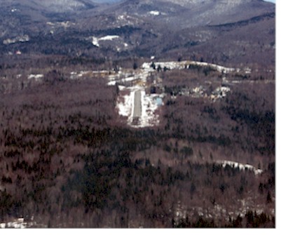
Airport Diagram might not be current.

Facility Name: DEERFIELD VALLEY RGNL
City Name: WEST DOVER
County: WINDHAM
State abbrev: VT
State Name: VERMONT
   
Ownership: PRIVATELY OWNED
Use: OPEN TO THE PUBLIC
Owner's Name: DEERFIELD VALLEY REG AIRPORT, LLC
Address: HERMITAGE REALTY ESTATE HOLDING CO., 25 HANDLE ROAD
 WEST DOVER, VT 05356
Owner's Phone: (802) 490-0775
  
Manager's Name: JIM BARNES
Address: P.O. BOX 2210, 69 AIRPORT ROAD
 WEST DOVER, VT 05356
Phone: (802) 490-0775; GTOOLE@GMAIL.COM
   
FAA Region: NEW ENGLAND
FAA Field Office: NONE


Sunrise / Sunset times for DEERFIELD VALLEY RGNL

DateSunriseSunset
04/15/24 Monday6:0919:35
04/16/24 Tuesday6:0719:36
04/17/24 Wednesday6:0519:37
04/18/24 Thursday6:0419:38
04/19/24 Friday6:0219:39
04/20/24 Saturday6:0119:41
04/21/24 Sunday5:5919:42
04/22/24 Monday5:5819:43
04/23/24 Tuesday5:5619:44
04/24/24 Wednesday5:5419:45
04/25/24 Thursday5:5319:46
04/26/24 Friday5:5219:47
04/27/24 Saturday5:5019:49
04/28/24 Sunday5:4919:50

Airport Facilities

Airport Attendance ScheduleUNATTND
Airport Status OPERATIONAL (This Status can change at any time - please check NOTAMS)
Airport Lighting ScheduleSS-SR
Airport Storage AvailableTie Downs, Hanger
Extra Services AvailableNONE
Wind IndicatorYES - (lighted)
Control TowerNO
CTAF Frequency122.800
Unicom Frequency122.800
Rotating Beacon Color
Segmented CircleNO
Landing FeeYES

Airport Inspection Data

Airport InspectedSTATE - performed by STATE AERONAUTICAL PERSONNEL
Inspection Date09/15/2015

Airport Services

Type of Fuel AvailableNone
Airframe Repair ServiceNone
Power Plant Repair ServiceNone

Geographic Data

LatitudeN4255.6
LongitudeW07251.9 (ESTIMATED)
Arpt Elevation1953ft (SURVEYED)
Magnetic Variation15W
1 miles SWof WEST DOVER
Traffic Pattern Altitude
Sectional ChartNEW YORK

Aircraft Data

Operations (Reported)YearlyAvg. Daily
General Aviation Transient 13004
General Aviation Local 18005
Air Taxi 00
Commerical 00
Commuter 00
Military 00
Aircraft based on Field
General Aviation Singles 5
General Aviation Multi 2
Jet Aircraft 0
General Aviation Helicopters 0
Military Aircraft 0
Gliders 0
Ultralights 0

FAA Services

FSS on field NO
FSS tie-in BURLINGTON
FSS Phone 1-800-WX-BRIEF
Who issues Notams BTV
Notam D service at airport YES
ARTCC Name BOSTON

Federal Status

Airport Certification
Aircraft Rescue & Firefighting IndexNone
Airport of EntryNo
Custom Landing RightsNo
Joint Civil/MilitaryNo
Military Landing rightsNo

Remarks

THIS AIRPORT HAS BEEN SURVEYED BY THE NATIONAL GEODETIC SURVEY.
FOR CD CTC BOSTON ARTCC AT 603-879-6859.
RWY 01/1 9 NSTD ALNMT.
Airport Communications & Frequencies:
CTAF Frequency:
122.800
Unicom Frequency:
122.800
Remarks
  • APCH/DEP SVC PRVDD BY BOSTON ARTCC ON FREQS 123.75/338.2 (GARDNER RCAG).
  • Runway Identifications
    Runway Identification: 01/19
    Length: 2650 ft
    Width: 75 ft
    Surface: ASPHALT
    Edge lights: Medium Intensity

    Treatment: NONE

     Runway: 01   Runway: 19
    Mag heading: Mag heading: 185°
    Rwy Slope: .08% UpRwy Slope: -.08% Down
    Approach: Approach:
    Pattern: Left TrafficPattern: Left Traffic
    Markings: NONPRECISION INSTRUMENTMarkings: BASIC
    Marking Condition: GOODMarking Condition: GOOD
    Arresting Dev: Arresting Dev:
    Lat & Long: N4255.4  W07251.9Lat. & Long.: N4255.8  W07252.0
    Elev: 1948.0 ft. MSLElev: 1950.0 ft. MSL
    TCH: TCH:
    Visual Glide Path: Visual Glide Path:
    Displaced Threshold: NoDisplaced Threshold: No
    Touchdown Zone: YESTouchdown Zone: NO
    Touchdown Elev.: 1953.0 feetTouchdown Elev.:
    Visual Glide Slope: Visual Glide Slope:
    RVR Equipment: RVR Equipment:
    RVV Equipment: NORVV Equipment: NO
    Approach Lights: Approach Lights:
    REIL: NOREIL: NO
    Centerline Lights: NOCenterline Lights: NO
    Touchdown lights: NOTouchdown lights: NO
    Runway Category: Runway with a Non-precision ApproachRunway Category: Runway with a Visual Approach
    Declared Distances: Declared Distances:
    Obstructions: TREESObstructions: TREES
    Marked: NOT Marked/LightedMarked: NOT Marked/Lighted
    Clearance slope: 7:1Clearance slope: 25:1
    Obstruction height: 61 feet AGLObstruction height: 29 feet AGL
    Dist. from runway: 662 feetDist. from runway: 945 feet
    Centerline offset: 54 right of centerlineCenterline offset: 160 feet left of centerline
    Comments: Comments:
    C:/P: