Current Weather/Notams (Metars, TAFs, Notams, NWS Forecast, PIREPS, and nearby weather)
Customs Information Send updates to Support@FltPlan.com
Customs Not Available
Database effective 05/16/2024
Airport Diagram might not be current.
|
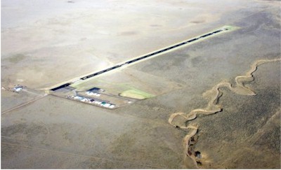
| Facility Name: | SPANISH PEAKS AIRFIELD |
| City Name: | WALSENBURG |
| County: | HUERFANO |
| State abbrev: | CO |
| State Name: | COLORADO |
| | |
| Ownership: | PUBLICLY OWNED |
| Use: | OPEN TO THE PUBLIC |
| Owner's Name: | HUERFANO COUNTY |
| Address: | COUNTY COURTHOUSE |
| | WALSENBURG, CO 81089 |
| Owner's Phone: | 719-738-2370 |
| | |
| Manager's Name: | DUSTIN HRIBAR |
| Address: | 401 MAIN ST |
| | WALSENBURG, CO 81089 |
| Phone: | 719-989-0376 |
| | |
| FAA Region: | NORTHWEST MOUNTAIN |
| FAA Field Office: | DEN |
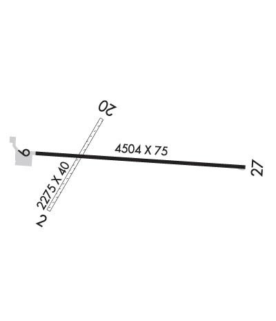
Runway Identifications
Runway Identification: 02/20Length: 2238 ft
Width: 40 ft
Surface: GRASS NATURAL SOIL-FAIR CONDITION
Edge lights: Treatment: NONE
| | Runway: 02 | | Runway: 20 |
| Mag heading: | 23° | Mag heading: | 203° |
| Rwy Slope: | -.97% Down | Rwy Slope: | .97% Up |
| Approach: | | Approach: | |
| Pattern: | Left Traffic | Pattern: | Left Traffic |
| Markings: | NONSTANDARD | Markings: | NONSTANDARD |
| Marking Condition: | FAIR | Marking Condition: | FAIR |
| Arresting Dev: | | Arresting Dev: | |
| Lat & Long: | N3741.6 W10447.4 | Lat. & Long.: | N3741.9 W10447.2 |
| Elev: | 6054.7 ft. MSL | Elev: | 6033.0 ft. MSL |
| TCH: | | TCH: | |
| Visual Glide Path: | | Visual Glide Path: | |
| Displaced Threshold: | No | Displaced Threshold: | No |
| Touchdown Zone: | YES | Touchdown Zone: | YES |
| Touchdown Elev.: | 6050.6 feet | Touchdown Elev.: | 6050.6 feet |
| Visual Glide Slope: | | Visual Glide Slope: | |
| RVR Equipment: | | RVR Equipment: | |
| RVV Equipment: | NO | RVV Equipment: | NO |
| Approach Lights: | | Approach Lights: | |
| REIL: | NO | REIL: | NO |
| Centerline Lights: | NO | Centerline Lights: | NO |
| Touchdown lights: | NO | Touchdown lights: | NO |
| Runway Category: | Runway with a Visual Approach | Runway Category: | Runway with a Visual Approach |
| Declared Distances: | TORA:2012' TODA:2012' ASDA:2012' LDA:2012' | Declared Distances: | TORA:2012' TODA:2012' ASDA:2012' LDA:2012' |
| Obstructions: | FENCE | Obstructions: | |
| Marked: | NOT Marked/Lighted | Marked: | |
| Clearance slope: | 16:1 | Clearance slope: | 50:1 |
| Obstruction height: | 12 feet AGL | Obstruction height: | |
| Dist. from runway: | 200 feet | Dist. from runway: | |
| Centerline offset: | | Centerline offset: | |
| Comments: | RWY 02 5 FT FENCE AT THLD BOTH SIDES OF CNTRLN. | Comments: | RWY 20 4 FT FENCE 240 FT FM THLD BOTH SIDES OF CNTRLN. |
Runway Identification: 09/27Length: 4715 ft
Width: 75 ft
Surface: ASPHALT-GOOD CONDITION
Edge lights: Medium IntensityTreatment: NONE
Weight: PCN 5 /F/C/Y/T
| | Runway: 09 | | Runway: 27 |
| Mag heading: | 85° | Mag heading: | 265° |
| Rwy Slope: | -.59% Down | Rwy Slope: | .59% Up |
| Approach: | | Approach: | |
| Pattern: | Left Traffic | Pattern: | Left Traffic |
| Markings: | NONPRECISION INSTRUMENT | Markings: | NONPRECISION INSTRUMENT |
| Marking Condition: | GOOD | Marking Condition: | GOOD |
| Arresting Dev: | | Arresting Dev: | |
| Lat & Long: | N3741.8 W10447.5 | Lat. & Long.: | N3741.8 W10446.5 |
| Elev: | 6046.9 ft. MSL | Elev: | 6019.1 ft. MSL |
| TCH: | 45 ft. AGL | TCH: | 45 ft. AGL |
| Visual Glide Path: | 3.00 degrees | Visual Glide Path: | 3.00 degrees |
| Displaced Threshold: | 210 feet | Displaced Threshold: | No |
| Touchdown Zone: | YES | Touchdown Zone: | YES |
| Touchdown Elev.: | 6047.0 feet | Touchdown Elev.: | 6036.8 feet |
| Visual Glide Slope: | 2-Light PAPI on LEFT side of Runway | Visual Glide Slope: | 2-Light PAPI on LEFT side of Runway |
| RVR Equipment: | | RVR Equipment: | |
| RVV Equipment: | NO | RVV Equipment: | NO |
| Approach Lights: | | Approach Lights: | |
| REIL: | NO | REIL: | NO |
| Centerline Lights: | NO | Centerline Lights: | NO |
| Touchdown lights: | NO | Touchdown lights: | NO |
| Runway Category: | Runway with a Visual Approach | Runway Category: | Runway with a Visual Approach |
| Declared Distances: | TORA:4502' TODA:4502' ASDA:4502' LDA:4502' | Declared Distances: | TORA:4712' TODA:4712' ASDA:4712' LDA:4712' |