Approach Charts
| FltPlan does not have IFR approach charts available for K4U9. |
Current Weather/Notams (Metars, TAFs, Notams, NWS Forecast, PIREPS, and nearby weather)
Customs Information Send updates to Support@FltPlan.com
Customs Not Available
Database effective 04/18/2024
Airport Diagram might not be current.
|
| Facility Name: | DELL FLIGHT STRIP |
| City Name: | DELL |
| County: | BEAVERHEAD |
| State abbrev: | MT |
| State Name: | MONTANA |
| | |
| Ownership: | PUBLICLY OWNED |
| Use: | OPEN TO THE PUBLIC |
| Owner's Name: | MONTANA AERONAUTICS DIVISION |
| Address: | PO BOX 200507 |
| | HELENA, MT 59620-0507 |
| Owner's Phone: | 406-444-2506 |
| | |
| Manager's Name: | TIM CONWAY |
| Address: | BOX 200507 |
| | HELENA, MT 59620-0507 |
| Phone: | 406-444-2506 |
| | |
| FAA Region: | NORTHWEST MOUNTAIN |
| FAA Field Office: | HLN |
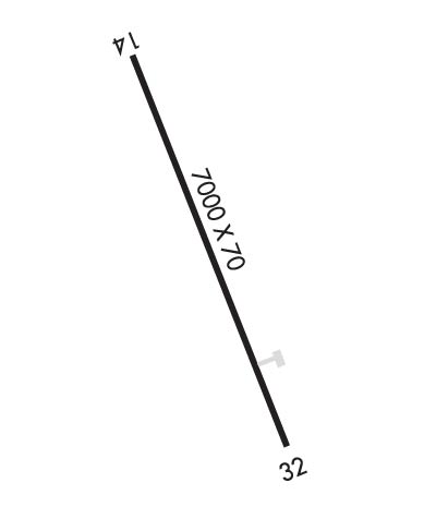
Runway Identifications
Runway Identification: 14/32Length: 7000 ft
Width: 70 ft
Surface: ASPHALT-POOR CONDITION
Edge lights: Medium IntensityTreatment: NONE
| | Runway: 14 | | Runway: 32 |
| Mag heading: | 143° | Mag heading: | 323° |
| Rwy Slope: | .70% Up | Rwy Slope: | -.70% Down |
| Approach: | | Approach: | |
| Pattern: | Left Traffic | Pattern: | Left Traffic |
| Markings: | NONSTANDARD | Markings: | NONSTANDARD |
| Marking Condition: | FAIR; RY 14/32 MKD WITH NUMBERS ONLY. NUMBERS NSTD SIZE AND FADED. | Marking Condition: | FAIR |
| Arresting Dev: | | Arresting Dev: | |
| Lat & Long: | N4444.7 W11243.5 | Lat. & Long.: | N4443.6 W11242.9 |
| Elev: | 5958.0 ft. MSL | Elev: | 6007.0 ft. MSL |
| TCH: | 30 ft. AGL | TCH: | |
| Visual Glide Path: | 3.50 degrees | Visual Glide Path: | |
| Displaced Threshold: | No | Displaced Threshold: | No |
| Touchdown Zone: | NO | Touchdown Zone: | NO |
| Touchdown Elev.: | | Touchdown Elev.: | |
| Visual Glide Slope: | 2-Light PAPI on LEFT side of Runway | Visual Glide Slope: | |
| RVR Equipment: | | RVR Equipment: | |
| RVV Equipment: | NO | RVV Equipment: | NO |
| Approach Lights: | | Approach Lights: | |
| REIL: | NO | REIL: | NO |
| Centerline Lights: | NO | Centerline Lights: | NO |
| Touchdown lights: | NO | Touchdown lights: | NO |
| Runway Category: | Runway with a Visual Approach | Runway Category: | Runway with a Visual Approach |
| Declared Distances: | | Declared Distances: | |
| Obstructions: | | Obstructions: | ROAD |
| Marked: | | Marked: | NOT Marked/Lighted |
| Clearance slope: | 20:1 | Clearance slope: | 16:1 |
| Obstruction height: | | Obstruction height: | 17 feet AGL |
| Dist. from runway: | | Dist. from runway: | 483 feet |
| Centerline offset: | | Centerline offset: | |
| Comments: | | Comments: | |

