Approach Charts
| FltPlan does not have IFR approach charts available for K4R9. |
Current Weather/Notams (Metars, TAFs, Notams, NWS Forecast, PIREPS, and nearby weather)
Customs Information Send updates to Support@FltPlan.com
Customs Not Available
Database effective 05/16/2024
Airport Diagram might not be current.
|
| Facility Name: | JEREMIAH DENTON |
| City Name: | DAUPHIN ISLAND |
| County: | MOBILE |
| State abbrev: | AL |
| State Name: | ALABAMA |
| | |
| Ownership: | PUBLICLY OWNED |
| Use: | OPEN TO THE PUBLIC |
| Owner's Name: | MOBILE COUNTY |
| Address: | 205 GOVERNMENT ST |
| | MOBILE, AL 36644 |
| Owner's Phone: | 251-574-8595 |
| | |
| Manager's Name: | WILLIAM MEREDITH |
| Address: | 7651 EDGAR ROBERTS RD |
| | IRVINGTON, AL 37544 |
| Phone: | 251-455-4300 |
| | |
| FAA Region: | SOUTHERN |
| FAA Field Office: | JAN |
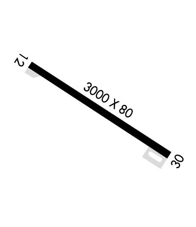
Runway Identifications
Runway Identification: 12/30Length: 3000 ft
Width: 80 ft
Surface: ASPHALT-FAIR CONDITION
Edge lights: Medium IntensityTreatment: NONE
| | Runway: 12 | | Runway: 30 |
| Mag heading: | N/A | Mag heading: | N/A |
| Rwy Slope: | .00% Down | Rwy Slope: | .00% Up |
| Approach: | | Approach: | |
| Pattern: | Left Traffic | Pattern: | Left Traffic |
| Markings: | BASIC | Markings: | BASIC |
| Marking Condition: | GOOD | Marking Condition: | GOOD |
| Arresting Dev: | | Arresting Dev: | |
| Lat & Long: | N3015.8 W08807.9 | Lat. & Long.: | N3015.5 W08807.4 |
| Elev: | 4.4 ft. MSL | Elev: | 4.3 ft. MSL |
| TCH: | 44 ft. AGL | TCH: | 51 ft. AGL |
| Visual Glide Path: | 3.00 degrees | Visual Glide Path: | 3.50 degrees |
| Displaced Threshold: | 202 feet | Displaced Threshold: | 140 feet |
| Touchdown Zone: | YES | Touchdown Zone: | YES |
| Touchdown Elev.: | 4.6 feet | Touchdown Elev.: | 4.6 feet |
| Visual Glide Slope: | 2-Light PAPI on LEFT side of Runway | Visual Glide Slope: | 2-Light PAPI on RIGHT side of Runway |
| RVR Equipment: | | RVR Equipment: | |
| RVV Equipment: | NO | RVV Equipment: | NO |
| Approach Lights: | | Approach Lights: | |
| REIL: | NO | REIL: | NO |
| Centerline Lights: | NO | Centerline Lights: | NO |
| Touchdown lights: | NO | Touchdown lights: | NO |
| Runway Category: | Runway with a Visual Approach | Runway Category: | Runway with a Visual Approach |
| Declared Distances: | | Declared Distances: | |
| Obstructions: | | Obstructions: | TREES |
| Marked: | | Marked: | NOT Marked/Lighted |
| Clearance slope: | 50:1; APCH SLOPE 50:1 TO DSPLCD THR. | Clearance slope: | 12:1; APCH SLP 18:1 TO DSPLCD THR. |
| Obstruction height: | | Obstruction height: | 61 feet AGL |
| Dist. from runway: | | Dist. from runway: | 979 feet |
| Centerline offset: | | Centerline offset: | 216 feet left of centerline |
| Comments: | | Comments: | |

