Click here for more info on on SMS!

K4R5

MADELINE ISLAND
LA POINTE
WI
Time Zone: Central
Lat: N 4647.3
Long: W 09045.5
Elev: 649
Var: -00
Longest Runway: 3000
CTAF: 122.9

FBO & Flight Services info for K4R5

FBOs: Update your Fuel Prices

AIRPORTPh: 715-747-6913
-
Freq: 122.9
Service
Jet
100LL
SAF
MoGas
Fuel Avail: NO FUEL AVAILABLE
Full        Last Update: 04/25/2024 05:27:33

Self        
If you are an FBO, call 1-203-262-1700 to update your info or email: FltPlan.Advertising@garmin.com
Advertise your FBO on FltPlan.com

Runway & Approach Info for K4R5
Rwy
Length
Land Dist**
Approach*
  Rwy
Length
Land Dist**
Approach*
04
3000x75  3000'          
 
  
22
  3000x75  3000'          
 
 * only ILS, LOC, LDA, and SDF approaches to a specific runway are shown
** For any Declared Landing Distance Available, please see A/FD or Approach plates
Runway Weight Capability (lbs.) Help
Runway IDSingle WheelDouble WheelDouble Tandem WheelDual Double Wheel
04/2212,500N/AN/AN/A
These numbers are Advisory and are not limits.   The Airport Manager should have more accurate Weight Limits
Approach Charts
Approaches    
Current Weather/Notams
Customs Information Send updates to Support@FltPlan.com
Customs Not Available
Database effective 05/16/2024
Airport Diagram of K4R5
Airport Diagram might not be current.

Facility Name: MAJOR GILBERT FLD
City Name: LA POINTE
County: ASHLAND
State abbrev: WI
State Name: WISCONSIN
   
Ownership: PUBLICLY OWNED
Use: OPEN TO THE PUBLIC
Owner's Name: TOWN OF LAPOINTE
Address: PO BOX 270
 LA POINTE, WI 54850
Owner's Phone: 715-747-6914
  
Manager's Name: PAUL WILHARM
Address: BOX 270
 LA POINTE, WI 54850
Phone: (612) 685-0445
   
FAA Region: GREAT LAKES
FAA Field Office: CHI


Sunrise / Sunset times for MAJOR GILBERT FLD

DateSunriseSunset
04/24/24 Wednesday5:5820:05
04/25/24 Thursday5:5620:06
04/26/24 Friday5:5520:07
04/27/24 Saturday5:5320:09
04/28/24 Sunday5:5220:10
04/29/24 Monday5:5020:11
04/30/24 Tuesday5:4820:13
05/01/24 Wednesday5:4720:14
05/02/24 Thursday5:4520:15
05/03/24 Friday5:4420:17
05/04/24 Saturday5:4220:18
05/05/24 Sunday5:4120:19
05/06/24 Monday5:3920:21
05/07/24 Tuesday5:3820:22

Airport Facilities

Airport Attendance ScheduleUNATTENDED
Airport Status OPERATIONAL (This Status can change at any time - please check NOTAMS)
Airport Lighting ScheduleACTVT REIL RWY 04; PAPI RWY 04 & 22 - CTAF. MIRL RWY 04/22 PRESET TO LOW SS-SR, TO INCR INTST & ACTVT - CTAF.
Airport Storage AvailableTie Downs
Extra Services AvailableNONE
Wind IndicatorYES - (lighted)
Control TowerNO
CTAF Frequency122.900
Unicom Frequency
Rotating Beacon ColorWG
Segmented CircleNO
Landing FeeNO

Airport Inspection Data

Airport InspectedSTATE - performed by STATE AERONAUTICAL PERSONNEL
Inspection Date08/23/2022

Airport Services

Type of Fuel AvailableNone
Airframe Repair ServiceNONE
Power Plant Repair ServiceNONE

Geographic Data

LatitudeN4647.3
LongitudeW09045.5 (ESTIMATED)
Arpt Elevation648ft (SURVEYED)
Magnetic Variation00E
2 miles NEof LA POINTE
Traffic Pattern Altitude
Sectional ChartGREEN BAY

Aircraft Data

Operations (Reported)YearlyAvg. Daily
General Aviation Transient 400011
General Aviation Local 20005
Air Taxi 500
Commerical 00
Commuter 00
Military 00
Aircraft based on Field
General Aviation Singles 1
General Aviation Multi 0
Jet Aircraft 0
General Aviation Helicopters 0
Military Aircraft 0
Gliders 0
Ultralights 0

FAA Services

FSS on field NO
FSS tie-in GREEN BAY
FSS Phone 1-800-WX-BRIEF
Who issues Notams GRB
Notam D service at airport YES
ARTCC Name MINNEAPOLIS

Federal Status

Airport Certification
Aircraft Rescue & Firefighting IndexNone
Airport of EntryNo
Custom Landing RightsNo
Joint Civil/MilitaryNo
Military Landing rightsYES

Federal Agreements

NATIONAL PLAN OF INTEGRATED AIRPORT SYSTEMS (NPIAS)
GRANT AGREEMENTS UNDER FAAP/ADAP/AIP
ASSURANCES PURSUANT TO TITLE VI, CIVIL RIGHTS ACT OF 1964

Remarks

DEER & WATERFOWL ON & INVOF ARPT.
FOR CD CTC MINNEAPOLIS ARTCC AT 651-463-5588.
Airport Communications & Frequencies:
CTAF Frequency:
122.900
Remarks
  • APCH/DEP SVC PRVDD BY MINNEANAPOLIS ARTCC (ZMP) ON FREQ 133.55 (IRONWOOD RCAG).
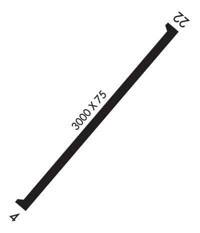
  • Runway Identifications
    Runway Identification: 04/22
    Length: 3000 ft
    Width: 75 ft
    Surface: ASPHALT
    Edge lights: Medium Intensity

    Treatment: NONE

     Runway: 04   Runway: 22
    Mag heading: 40°Mag heading: 220°
    Rwy Slope: .81% UpRwy Slope: -.81% Down
    Approach: Approach:
    Pattern: Left TrafficPattern: Left Traffic
    Markings: NONPRECISION INSTRUMENTMarkings: NONPRECISION INSTRUMENT
    Marking Condition: GOODMarking Condition: GOOD
    Arresting Dev: Arresting Dev:
    Lat & Long: N4647.1  W09045.8Lat. & Long.: N4647.5  W09045.3
    Elev: 624.3 ft. MSLElev: 648.6 ft. MSL
    TCH: 45 ft. AGLTCH: 45 ft. AGL
    Visual Glide Path: 3.75 degreesVisual Glide Path: 3.75 degrees
    Displaced Threshold: NoDisplaced Threshold: No
    Touchdown Zone: YESTouchdown Zone: YES
    Touchdown Elev.: 648.6 feetTouchdown Elev.: 648.6 feet
    Visual Glide Slope: 2-Light PAPI on LEFT side of RunwayVisual Glide Slope: 2-Light PAPI on LEFT side of Runway
    RVR Equipment: RVR Equipment:
    RVV Equipment: NORVV Equipment: NO
    Approach Lights: Approach Lights:
    REIL: YESREIL: NO
    Centerline Lights: NOCenterline Lights: NO
    Touchdown lights: NOTouchdown lights: NO
    Runway Category: Runway with a Non-precision ApproachRunway Category: Runway with a Non-precision Approach
    Declared Distances: Declared Distances:
    Obstructions: TREESObstructions: TREES
    Marked: NOT Marked/LightedMarked: NOT Marked/Lighted
    Clearance slope: 17:1Clearance slope: 1:1
    Obstruction height: 56 feet AGLObstruction height: 45 feet AGL
    Dist. from runway: 1200 feetDist. from runway: 240 feet
    Centerline offset: 370 left of centerlineCenterline offset: 235 feet left of centerline
    Comments: Comments: 40 FT TREES 190 FT FM RWY END, 230 FT L.
    C:2/P: