Current Weather/Notams (Metars, TAFs, Notams, NWS Forecast, PIREPS, and nearby weather)
Customs Information Send updates to Support@FltPlan.com
Customs Not Available
Database effective 04/18/2024
Airport Diagram might not be current.
|
| Facility Name: | MORROW COUNTY |
| City Name: | MOUNT GILEAD |
| County: | MORROW |
| State abbrev: | OH |
| State Name: | OHIO |
| | |
| Ownership: | PUBLICLY OWNED |
| Use: | OPEN TO THE PUBLIC |
| Owner's Name: | MORROW COUNTY ARPT AUTH |
| Address: | 4679 TOWNSHIP ROAD 126 |
| | CARDINGTON, OH 43315-9511 |
| Owner's Phone: | 419-947-4735; COUNTY ECONOMIC DEVELOPMENT OFC. |
| | |
| Manager's Name: | CARL FISHER JR |
| Address: | 4679 TOWNSHIP ROAD 126 |
| | CARDINGTON, OH 43315-9511 |
| Phone: | 419-947-1833; OFC. |
| | |
| FAA Region: | GREAT LAKES |
| FAA Field Office: | DET |
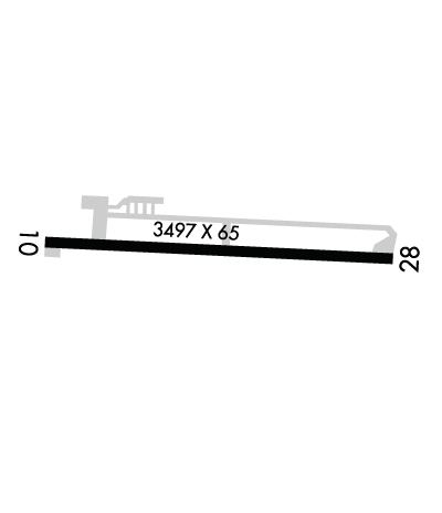
Runway Identifications
Runway Identification: 10/28Length: 3495 ft
Width: 65 ft
Surface: ASPHALT-FAIR CONDITION
Edge lights: Medium IntensityTreatment: NONE
| | Runway: 10 | | Runway: 28 |
| Mag heading: | 99° | Mag heading: | 279° |
| Rwy Slope: | .28% Up | Rwy Slope: | -.28% Down |
| Approach: | | Approach: | |
| Pattern: | Left Traffic | Pattern: | Left Traffic |
| Markings: | NONPRECISION INSTRUMENT | Markings: | NONPRECISION INSTRUMENT |
| Marking Condition: | GOOD | Marking Condition: | GOOD |
| Arresting Dev: | | Arresting Dev: | |
| Lat & Long: | N4031.5 W08251.4 | Lat. & Long.: | N4031.5 W08250.6 |
| Elev: | 1075.2 ft. MSL | Elev: | 1085.0 ft. MSL |
| TCH: | | TCH: | 46 ft. AGL |
| Visual Glide Path: | | Visual Glide Path: | 4.00 degrees |
| Displaced Threshold: | No | Displaced Threshold: | No |
| Touchdown Zone: | YES | Touchdown Zone: | YES |
| Touchdown Elev.: | 1085.8 feet | Touchdown Elev.: | 1085.8 feet |
| Visual Glide Slope: | | Visual Glide Slope: | 4-Light PAPI on LEFT side of Runway |
| RVR Equipment: | | RVR Equipment: | |
| RVV Equipment: | NO | RVV Equipment: | NO |
| Approach Lights: | | Approach Lights: | |
| REIL: | NO | REIL: | NO |
| Centerline Lights: | NO | Centerline Lights: | NO |
| Touchdown lights: | NO | Touchdown lights: | NO |
| Runway Category: | Runway with a Visual Approach | Runway Category: | Runway with a Visual Approach |
| Declared Distances: | | Declared Distances: | |
| Obstructions: | TREES | Obstructions: | TREES |
| Marked: | NOT Marked/Lighted | Marked: | NOT Marked/Lighted |
| Clearance slope: | 12:1 | Clearance slope: | 11:1 |
| Obstruction height: | 56 feet AGL | Obstruction height: | 60 feet AGL |
| Dist. from runway: | 903 feet | Dist. from runway: | 916 feet |
| Centerline offset: | 308 left of centerline | Centerline offset: | 303 feet left of centerline |
| Comments: | +2 FT CROPS, 60-200 FT DIST, 60-250 FT L. | Comments: | |

