Click here for more info on on SMS!

K4I3

KNOX COUNTY
MOUNT VERNON
OH
Time Zone: Eastern
Lat: N 4019.7
Long: W 08231.6
Elev: 1192
Var: +06
Longest Runway: 5504
Clr Del: 119.45
AWOS: 126.05
CTAF: 123.05

FBO & Flight Services info for K4I3

FBOs: Update your Fuel Prices
Providing high quality fuel and services to you and your customers, from Phillips 66 Aviation.
Ph: 740-397-9647 Fax: 740-397-3222 Freq: 123.05Website-
Service
Jet
100LL
SAF
MoGas
Fuel Avail: PRIST PREMIXED,
Full4.807.22    Caution: Fuel prices have not been updated in 36 days.
Last Update: 03/15/2024 07:32

Self  7.22    
Misc. Info: Address: 6481 KINNEY ROAD.   MT.VERNON, OH 43050

AWOSPh: 740-397-6297
-
Freq: 126.05  
If you are an FBO, call 1-203-262-1700 to update your info or email: FltPlan.Advertising@garmin.com
Advertise your FBO on FltPlan.com

Runway & Approach Info for K4I3
Rwy
Length
Land Dist**
Approach*
  Rwy
Length
Land Dist**
Approach*
10
5504x100  5504'          
 
  
28
  5504x100  5504'          
 
 * only ILS, LOC, LDA, and SDF approaches to a specific runway are shown
** For any Declared Landing Distance Available, please see A/FD or Approach plates
Runway Weight Capability (lbs.) Help
Runway IDSingle WheelDouble WheelDouble Tandem WheelDual Double Wheel
10/2855,000100,000N/AN/A
These numbers are Advisory and are not limits.   The Airport Manager should have more accurate Weight Limits
Approach Charts
Approaches    
Current Weather/Notams
Customs Information Send updates to Support@FltPlan.com
Customs Not Available
Database effective 04/18/2024
Airport Diagram of K4I3
Airport Diagram might not be current.
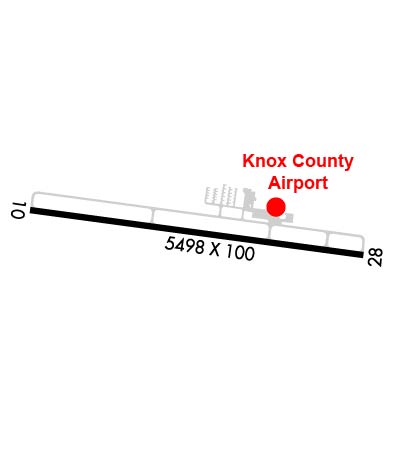
Facility Name: KNOX COUNTY
City Name: MOUNT VERNON
County: KNOX
State abbrev: OH
State Name: OHIO
   
Ownership: PUBLICLY OWNED
Use: OPEN TO THE PUBLIC
Owner's Name: KNOX CO ARPT AUTHORITY
Address: 6481 KINNEY RD
 MOUNT VERNON, OH 43050-9301
Owner's Phone: 740-397-9647
  
Manager's Name: JOSH WYNN; KNOXAIRPORT@EMBARQMAIL.COM.
Address: 6481 KINNEY RD
 MOUNT VERNON, OH 43050-9301
Phone: 740-397-9647
   
FAA Region: GREAT LAKES
FAA Field Office: DET


Sunrise / Sunset times for KNOX COUNTY

DateSunriseSunset
04/19/24 Friday6:4520:14
04/20/24 Saturday6:4320:15
04/21/24 Sunday6:4220:16
04/22/24 Monday6:4120:17
04/23/24 Tuesday6:3920:18
04/24/24 Wednesday6:3820:19
04/25/24 Thursday6:3620:20
04/26/24 Friday6:3520:21
04/27/24 Saturday6:3420:22
04/28/24 Sunday6:3220:23
04/29/24 Monday6:3120:24
04/30/24 Tuesday6:3020:25
05/01/24 Wednesday6:2920:26
05/02/24 Thursday6:2720:27

Airport Facilities

Airport Attendance ScheduleMON-FRI 0700-1700, SAT-SUN 0900-1700; 24 HR PN FOR ATNDNC AFT HRS - CALL AMGR.
Airport Status OPERATIONAL (This Status can change at any time - please check NOTAMS)
Airport Lighting ScheduleACTVT REIL RWY 10 & 28; MIRL RWY 10/28 - CTAF. PAPI RWY 10 & 28 OPR CONSLY.
Airport Storage AvailableTie Downs, Hanger
Extra Services AvailableCrop Dusting, Flight Instruction, Aircraft Rental
Wind IndicatorYES - (lighted)
Control TowerNO
CTAF Frequency123.050
Unicom Frequency123.050
Rotating Beacon ColorWG
Segmented CircleNO
Landing FeeNO

Airport Inspection Data

Airport InspectedSTATE - performed by STATE AERONAUTICAL PERSONNEL
Inspection Date08/02/2023

Airport Services

Type of Fuel AvailableGrade 100LL, JET A; -10FUEL AVBL H24 SELF SER VIA CREDIT CARD.
Airframe Repair ServiceMAJOR
Power Plant Repair ServiceMAJOR

Geographic Data

LatitudeN4019.7
LongitudeW08231.6 (ESTIMATED)
Arpt Elevation1191ft (SURVEYED)
Magnetic Variation06W
4 miles SWof MOUNT VERNON
Traffic Pattern Altitude808
Sectional ChartDETROIT

Aircraft Data

Operations (Reported)YearlyAvg. Daily
General Aviation Transient 950026
General Aviation Local 1400038
Air Taxi 5001
Commerical 00
Commuter 00
Military 1500
Aircraft based on Field
General Aviation Singles 71
General Aviation Multi 3
Jet Aircraft 1
General Aviation Helicopters 0
Military Aircraft 0
Gliders 0
Ultralights 0

FAA Services

FSS on field NO
FSS tie-in CLEVELAND
FSS Phone 1-800-WX-BRIEF
Who issues Notams CLE
Notam D service at airport YES
ARTCC Name INDIANAPOLIS

Federal Status

Airport Certification
Aircraft Rescue & Firefighting IndexNone
Airport of EntryNo
Custom Landing RightsNo
Joint Civil/MilitaryNo
Military Landing rightsYES

Federal Agreements

NATIONAL PLAN OF INTEGRATED AIRPORT SYSTEMS (NPIAS)
ASSURANCES PURSUANT TO TITLE VI, CIVIL RIGHTS ACT OF 1964
GRANT AGREEMENT HAS EXPIRED; HOWEVER, AGREEMENT REMAINS IN EFFECT FOR THIS FACILITY AS LONG AS IT IS PUBLIC USE.

Remarks

DEER, BIRDS, & OTR WILDLIFE ON & INVOF ARPT.
Airport Communications & Frequencies:
Clearance Delivery Frequencies:
119.45
CTAF Frequency:
123.050
Unicom Frequency:
123.050
COLUMBUS Primary Approach Frequencies:  
125.95
317.775
COLUMBUS Primary Departure Frequencies:  
125.95
317.775
Runway Identifications
Runway Identification: 10/28
Length: 5504 ft
Width: 100 ft
Surface: ASPHALT-GOOD CONDITION
Edge lights: Medium Intensity

Treatment: GROOVED

 Runway: 10   Runway: 28
Mag heading: 104°Mag heading: 284°
Rwy Slope: -.05% DownRwy Slope: .05% Up
Approach: Approach:
Pattern: Left TrafficPattern: Left Traffic
Markings: NONPRECISION INSTRUMENTMarkings: NONPRECISION INSTRUMENT
Marking Condition: GOODMarking Condition: GOOD
Arresting Dev: Arresting Dev:
Lat & Long: N4019.8  W08232.2Lat. & Long.: N4019.7  W08231.0
Elev: 1187.3 ft. MSLElev: 1184.4 ft. MSL
TCH: 40 ft. AGLTCH: 40 ft. AGL
Visual Glide Path: 3.00 degreesVisual Glide Path: 3.00 degrees
Displaced Threshold: NoDisplaced Threshold: No
Touchdown Zone: YESTouchdown Zone: YES
Touchdown Elev.: 1191.6 feetTouchdown Elev.: 1189.8 feet
Visual Glide Slope: 4-Light PAPI on LEFT side of RunwayVisual Glide Slope: 4-Light PAPI on LEFT side of Runway
RVR Equipment: RVR Equipment:
RVV Equipment: NORVV Equipment: NO
Approach Lights: Approach Lights:
REIL: YESREIL: YES
Centerline Lights: NOCenterline Lights: NO
Touchdown lights: NOTouchdown lights: NO
Runway Category: Runway with a Non-precision Approach having visibility minimums greater than 3/4 mileRunway Category: Runway with a Non-precision Approach having visibility minimums greater than 3/4 mile
Declared Distances: Declared Distances:
Obstructions: TREESObstructions: TREES
Marked: NOT Marked/LightedMarked: NOT Marked/Lighted
Clearance slope: 23:1Clearance slope: 34:1
Obstruction height: 126 feet AGLObstruction height: 51 feet AGL
Dist. from runway: 3188 feetDist. from runway: 1962 feet
Centerline offset: 60 left of centerlineCenterline offset: 65 feet left of centerline
Comments: Comments:
C:5/P: