Click here for more info on on SMS!

K4G7

FAIRMONT MUNI-FRANKMAN FIELD
FAIRMONT
WV
Time Zone: Eastern
Lat: N 3926.9
Long: W 08010.1
Elev: 1032
Var: +09
Longest Runway: 2965
Clr Del: 118.35
CTAF: 122.8

FBO & Flight Services info for K4G7

FBOs: Update your Fuel Prices
We have a passion for being in the air. Leading Edge is about sharing that passion with others and helping attain what we all have, a desire to grow wings and fly. Our flight training is second to none, and our aircraft management and maintenance team treat your aircraft as if it were their own.
Ph: 304-363-1468
-
Freq: 122.8WebsiteE-Mail
                                  
Service
Jet
100LL
SAF
MoGas
Fuel Avail: ~~FLIGHT SCHOOL CALL 1ST
Full        Last Update: 04/18/2024 05:44:56

Self        
Misc. Info: Address: 1150 AIRPORT RD   FAIRMONT, WV 26554

If you are an FBO, call 1-203-262-1700 to update your info or email: FltPlan.Advertising@garmin.com
Advertise your FBO on FltPlan.com

Runway & Approach Info for K4G7
Rwy
Length
Land Dist**
Approach*
  Rwy
Length
Land Dist**
Approach*
05
2965x75  2245'          
 
  
23
  2965x75  2965'          
 
 * only ILS, LOC, LDA, and SDF approaches to a specific runway are shown
** For any Declared Landing Distance Available, please see A/FD or Approach plates
Runway Weight Capability (lbs.) Help
Runway IDSingle WheelDouble WheelDouble Tandem WheelDual Double Wheel
05/2312,500N/AN/AN/A
These numbers are Advisory and are not limits.   The Airport Manager should have more accurate Weight Limits
Approach Charts
Approaches    
Current Weather/Notams
Customs Information Send updates to Support@FltPlan.com
Customs Not Available
Database effective 04/18/2024
Airport Diagram of K4G7
Airport Diagram might not be current.

Facility Name: FAIRMONT MUNI-FRANKMAN FLD
City Name: FAIRMONT
County: MARION
State abbrev: WV
State Name: WEST VIRGINIA
   
Ownership: PUBLICLY OWNED
Use: OPEN TO THE PUBLIC
Owner's Name: FAIRMONT-MARION CO REG ARPT AUTH
Address: P.O. BOX 387
 FAIRMONT, WV 26555-0387
Owner's Phone: 304-282-5289
  
Manager's Name: DONNIE TUCKER
Address: PO BOX 387
 FAIRMONT, WV 26555
Phone: 304-366-1300; 304-612-4015 MGR CELL
   
FAA Region: EASTERN
FAA Field Office: BKW


Sunrise / Sunset times for FAIRMONT MUNI-FRANKMAN FLD

DateSunriseSunset
04/17/24 Wednesday6:4020:01
04/18/24 Thursday6:3820:02
04/19/24 Friday6:3720:03
04/20/24 Saturday6:3520:04
04/21/24 Sunday6:3420:05
04/22/24 Monday6:3320:06
04/23/24 Tuesday6:3120:07
04/24/24 Wednesday6:3020:08
04/25/24 Thursday6:2820:09
04/26/24 Friday6:2720:10
04/27/24 Saturday6:2620:11
04/28/24 Sunday6:2520:12
04/29/24 Monday6:2320:13
04/30/24 Tuesday6:2220:14

Airport Facilities

Airport Attendance ScheduleAPR-OCT 7 Days A Week 0800-DUSK, NOV-MAR 7 Days A Week 0900-1700
Airport Status OPERATIONAL (This Status can change at any time - please check NOTAMS)
Airport Lighting ScheduleRWY 05/23 MIRL OPR CONSLY DUSK TO 2400. AFTR 2400, ACTVT REIL RWY 23; MIRL RWY 5/23 - CTAF.
Airport Storage AvailableTie Downs
Extra Services AvailableNONE
Wind IndicatorYES - (lighted)
Control TowerNO
CTAF Frequency122.800
Unicom Frequency122.800
Rotating Beacon ColorWG
Segmented CircleNO
Landing FeeNO

Airport Inspection Data

Airport InspectedSTATE - performed by PRIVATE CONTRACT PERSONNEL
Inspection Date07/11/2021

Airport Services

Type of Fuel AvailableGrade 100LL
Airframe Repair ServiceMAJOR
Power Plant Repair ServiceMAJOR

Geographic Data

LatitudeN3926.9
LongitudeW08010.1 (ESTIMATED)
Arpt Elevation1032ft (SURVEYED)
Magnetic Variation09W
2 miles SWof FAIRMONT
Traffic Pattern Altitude
Sectional ChartCINCINNATI

Aircraft Data

Operations (Reported)YearlyAvg. Daily
General Aviation Transient 24007
General Aviation Local 600016
Air Taxi 00
Commerical 00
Commuter 00
Military 5001
Aircraft based on Field
General Aviation Singles 36
General Aviation Multi 1
Jet Aircraft 0
General Aviation Helicopters 1
Military Aircraft 0
Gliders 0
Ultralights 0

FAA Services

FSS on field NO
FSS tie-in ELKINS
FSS Phone 1-800-WX-BRIEF
Who issues Notams EKN
Notam D service at airport YES
ARTCC Name CLEVELAND

Federal Status

Airport Certification
Aircraft Rescue & Firefighting IndexNone
Airport of EntryNo
Custom Landing RightsNo
Joint Civil/MilitaryNo
Military Landing rightsNo

Federal Agreements

NATIONAL PLAN OF INTEGRATED AIRPORT SYSTEMS (NPIAS)

Remarks

RADIO TOWERS APRX 300' AGL 2 MILES NE AND 2.5 MILES NW OF ARPT.
DEER ON & INVOF ARPT.
RWY 23 HAS 100 FT DROP OFF, NE END.
RWY 5 HAS +30 FT HILL AT SW END.
FOR CD CTC CLARKSBURG APCH AT 304-842-2011, WHEN APCH CLSD CTC CLEVELAND ARTCC AT 440-774-0226.
Airport Communications & Frequencies:
Clearance Delivery Frequencies:
118.35
CTAF Frequency:
122.800
Unicom Frequency:
122.800
Remarks
  • APCH/DEP SVC PRVDD BY CLEVELAND ARTCC (ZOB) ON FREQS 126.95/239.3 (BELMONT RCAG) WHEN CLARKSBURG APCH CTL CLSD.
  • CLARKSBURG Primary Approach Frequencies:  
    121.15
    284.65
    CLARKSBURG Primary Departure Frequencies:  
    121.15
    284.65
    Runway Identifications
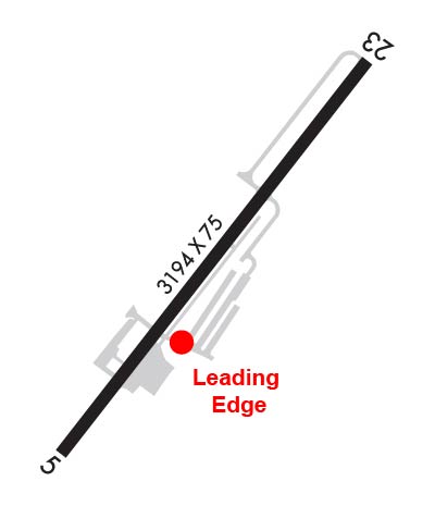
    Runway Identification: 05/23
    Length: 2965 ft
    Width: 75 ft
    Surface: ASPHALT-GOOD CONDITION
    Edge lights: Medium Intensity

    Treatment: NONE

     Runway: 05   Runway: 23
    Mag heading: 46°Mag heading: 226°
    Rwy Slope: -.67% DownRwy Slope: .67% Up
    Approach: Approach:
    Pattern: Left TrafficPattern: Left Traffic
    Markings: BASICMarkings: BASIC
    Marking Condition: GOODMarking Condition: GOOD
    Arresting Dev: Arresting Dev:
    Lat & Long: N3926.7  W08010.2Lat. & Long.: N3927.0  W08009.9
    Elev: 1032.4 ft. MSLElev: 1012.6 ft. MSL
    TCH: TCH:
    Visual Glide Path: Visual Glide Path:
    Displaced Threshold: 720 feetDisplaced Threshold: No
    Touchdown Zone: YESTouchdown Zone: YES
    Touchdown Elev.: 1026.9 feetTouchdown Elev.: 1032.4 feet
    Visual Glide Slope: Visual Glide Slope:
    RVR Equipment: RVR Equipment:
    RVV Equipment: NORVV Equipment: NO
    Approach Lights: Approach Lights:
    REIL: NOREIL: YES
    Centerline Lights: NOCenterline Lights: NO
    Touchdown lights: NOTouchdown lights: NO
    Runway Category: Runway with a Visual ApproachRunway Category: Runway with a Non-precision Approach
    Declared Distances: Declared Distances:
    Obstructions: GNDObstructions: TREES
    Marked: NOT Marked/LightedMarked: NOT Marked/Lighted
    Clearance slope: APCH RATIO O:1 AT DSPLCD THLD OVR 6 FT FENCE, 0 FT DSTC, 130 FT L.Clearance slope:
    Obstruction height: 30 feet AGLObstruction height: 12 feet AGL
    Dist. from runway: 201 feetDist. from runway: 201 feet
    Centerline offset: 73 left of centerlineCenterline offset: 235 feet left of centerline
    Comments: +30 FT HILL 201 FT FM THLD 0B.Comments: 12 FT TREES, 199 FT DSTC, 235 R.
    C:/P: