Current Weather/Notams (Metars, TAFs, Notams, NWS Forecast, PIREPS, and nearby weather)
Customs Information Send updates to Support@FltPlan.com
Customs Not Available
Database effective 05/16/2024
Airport Diagram might not be current.
|
| Facility Name: | MONROE COUNTY |
| City Name: | WOODSFIELD |
| County: | MONROE |
| State abbrev: | OH |
| State Name: | OHIO |
| | |
| Ownership: | PUBLICLY OWNED |
| Use: | OPEN TO THE PUBLIC |
| Owner's Name: | MONROE COUNTY COMMISSIONERS |
| Address: | 101 N MAIN ST |
| | WOODSFIELD, OH 43793-1070 |
| Owner's Phone: | 740-472-1341 |
| | |
| Manager's Name: | DAVID DALRYMPLE |
| Address: | 47073 STATE ROUTE 26 |
| | WOODSFIELD, OH 43793-9330 |
| Phone: | 740-472-1882; CELL 740-213-3106. |
| | |
| FAA Region: | GREAT LAKES |
| FAA Field Office: | DET |
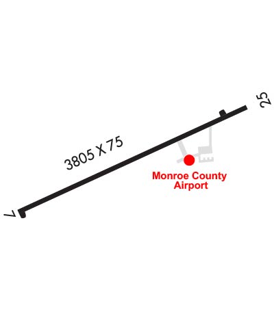
Runway Identifications
Runway Identification: 07/25Length: 3805 ft
Width: 75 ft
Surface: ASPHALT-GOOD CONDITION
Edge lights: Medium IntensityTreatment: NONE
| | Runway: 07 | | Runway: 25 |
| Mag heading: | 74° | Mag heading: | 254° |
| Rwy Slope: | -.08% Down | Rwy Slope: | .08% Up |
| Approach: | | Approach: | |
| Pattern: | Left Traffic | Pattern: | Left Traffic |
| Markings: | NONPRECISION INSTRUMENT | Markings: | NONPRECISION INSTRUMENT |
| Marking Condition: | GOOD | Marking Condition: | GOOD |
| Arresting Dev: | | Arresting Dev: | |
| Lat & Long: | N3946.6 W08106.5 | Lat. & Long.: | N3946.9 W08105.8 |
| Elev: | 1193.9 ft. MSL | Elev: | 1190.7 ft. MSL |
| TCH: | | TCH: | 40 ft. AGL |
| Visual Glide Path: | | Visual Glide Path: | 3.00 degrees |
| Displaced Threshold: | 174 feet | Displaced Threshold: | No |
| Touchdown Zone: | YES | Touchdown Zone: | YES |
| Touchdown Elev.: | 1197.1 feet | Touchdown Elev.: | 1197.1 feet |
| Visual Glide Slope: | | Visual Glide Slope: | 2-Light PAPI on LEFT side of Runway |
| RVR Equipment: | | RVR Equipment: | |
| RVV Equipment: | NO | RVV Equipment: | NO |
| Approach Lights: | | Approach Lights: | |
| REIL: | NO | REIL: | YES |
| Centerline Lights: | NO | Centerline Lights: | NO |
| Touchdown lights: | NO | Touchdown lights: | NO |
| Runway Category: | Runway with a Visual Approach | Runway Category: | Runway with a Non-precision Approach |
| Declared Distances: | | Declared Distances: | |
| Obstructions: | TREES | Obstructions: | TREES |
| Marked: | NOT Marked/Lighted | Marked: | NOT Marked/Lighted |
| Clearance slope: | 9:1; APCH RATIO 17:1 TO DTHR. | Clearance slope: | |
| Obstruction height: | 140 feet AGL | Obstruction height: | 23 feet AGL |
| Dist. from runway: | 1582 feet | Dist. from runway: | 238 feet |
| Centerline offset: | 260 right of centerline | Centerline offset: | 140 feet left of centerline |
| Comments: | | Comments: | 0-15 FT TREES & BRUSH, 0-200 FT DIST, 135-210 FT L. |