Click here for more info on on SMS!

K4G4

YOUNGSTOWN ELSER METRO
YOUNGSTOWN
OH
Time Zone: Eastern
Lat: N 4057.7
Long: W 08040.6
Elev: 1070
Var: +08
Longest Runway: 4012
Clr Del: 119.25
CTAF: 123.05

FBO & Flight Services info for K4G4

FBOs: Update your Fuel Prices

GEMCO AV SVCSPh: 330-549-0337 Fax: 330-549-0341 Freq: 123.05
Service
Jet
100LL
SAF
MoGas
Fuel Avail: JET A INCLUDES PRIST. 8A-7P . AFTER HRS AVAIL
Full5.906.58    Last Update: 04/19/2024 07:43

Self        
 Address: 10800 SHARROTT RD, NORTH LIMA,   OH 44452-9523
If you are an FBO, call 1-203-262-1700 to update your info or email: FltPlan.Advertising@garmin.com
Advertise your FBO on FltPlan.com

Runway & Approach Info for K4G4
Rwy
Length
Land Dist**
Approach*
  Rwy
Length
Land Dist**
Approach*
10
4012x50  3664'          
 
  
28
  4012x50  3753'          
 
 * only ILS, LOC, LDA, and SDF approaches to a specific runway are shown
** For any Declared Landing Distance Available, please see A/FD or Approach plates
Runway Weight Capability (lbs.) Help
Runway IDSingle WheelDouble WheelDouble Tandem WheelDual Double Wheel
10/28N/AN/AN/AN/A
These numbers are Advisory and are not limits.   The Airport Manager should have more accurate Weight Limits
Approach Charts
Approaches    
Current Weather/Notams
Customs Information Send updates to Support@FltPlan.com
Customs Not Available
Database effective 05/16/2024
Airport Diagram of K4G4
Airport Diagram might not be current.

Facility Name: YOUNGSTOWN ELSER METRO
City Name: YOUNGSTOWN
County: MAHONING
State abbrev: OH
State Name: OHIO
   
Ownership: PRIVATELY OWNED
Use: OPEN TO THE PUBLIC
Owner's Name: MICHAEL E STANKO
Address: 8491 IVY HILL DR
 POLAND, OH 44514-5214
Owner's Phone: 330-757-1147
  
Manager's Name: MICHAEL E STANKO
Address: 10800 SHARROTT RD
 NORTH LIMA, OH 44452-9523
Phone: 330-549-0337
   
FAA Region: GREAT LAKES
FAA Field Office: DET


Sunrise / Sunset times for YOUNGSTOWN ELSER METRO

DateSunriseSunset
04/23/24 Tuesday6:3120:12
04/24/24 Wednesday6:2920:13
04/25/24 Thursday6:2820:14
04/26/24 Friday6:2620:15
04/27/24 Saturday6:2520:16
04/28/24 Sunday6:2420:17
04/29/24 Monday6:2220:18
04/30/24 Tuesday6:2120:19
05/01/24 Wednesday6:2020:20
05/02/24 Thursday6:1920:21
05/03/24 Friday6:1720:22
05/04/24 Saturday6:1620:23
05/05/24 Sunday6:1520:24
05/06/24 Monday6:1420:25

Airport Facilities

Airport Attendance Schedule7 Days A Week 0730-1800; UNATNDD EASTER, THANKSGIVING, & CHRISTMAS.
Airport Status OPERATIONAL (This Status can change at any time - please check NOTAMS)
Airport Lighting ScheduleSS-SR
Airport Storage AvailableHanger
Extra Services AvailableAir Ambulance, Flight Instruction, Aircraft Rental, Aircraft Sales
Wind IndicatorYES - (unlit)
Control TowerNO
CTAF Frequency123.050
Unicom Frequency123.050
Rotating Beacon ColorWG
Segmented CircleNO
Landing FeeNO

Airport Inspection Data

Airport InspectedSTATE - performed by STATE AERONAUTICAL PERSONNEL
Inspection Date09/24/2021

Airport Services

Type of Fuel AvailableGrade 100LL, JET A (freeze point -40C), JET A
Airframe Repair ServiceMAJOR
Power Plant Repair ServiceMAJOR

Geographic Data

LatitudeN4057.7
LongitudeW08040.6 (ESTIMATED)
Arpt Elevation1069ft (SURVEYED)
Magnetic Variation08W
7 miles SWof YOUNGSTOWN
Traffic Pattern Altitude
Sectional ChartDETROIT

Aircraft Data

Operations (Reported)YearlyAvg. Daily
General Aviation Transient 6002
General Aviation Local 400011
Air Taxi 1100
Commerical 00
Commuter 00
Military 1000
Aircraft based on Field
General Aviation Singles 46
General Aviation Multi 5
Jet Aircraft 1
General Aviation Helicopters 20
Military Aircraft 0
Gliders 0
Ultralights 0

FAA Services

FSS on field NO
FSS tie-in CLEVELAND
FSS Phone 1-800-WX-BRIEF
Who issues Notams CLE
Notam D service at airport YES
ARTCC Name CLEVELAND

Federal Status

Airport Certification
Aircraft Rescue & Firefighting IndexNone
Airport of EntryNo
Custom Landing RightsNo
Joint Civil/MilitaryNo
Military Landing rightsNo

Remarks

TWR 1085'AGL /2118'MSL/ LCTD 7-1/2 NM NNE.
FOR CD CTC CLEVELAND APCH AT 216-352-2323, WHEN APCH CLSD CTC CLEVELAND ARTCC AT 440-774-0223/0490.
RWY 10 CALM WIND RWY.
RWY 10/2 8 LRG TRANSVERSE CTL CRACKS SPACED DOWN RWY.
Airport Communications & Frequencies:
Clearance Delivery Frequencies:
119.25
CTAF Frequency:
123.050
Unicom Frequency:
123.050
Remarks
  • APCH/DEP SVC PRVDD BY CLEVELAND APCH (CLE) 0600-0100. APCH/DEP SVC PRVDD BY CLEVELAND ARTCC (ZOB) ON FREQS 120.6/379.275 (MOUNT HOPE RCAG) 0100-0600.
  • CLEVELAND Primary Approach Frequencies:  
    125.5
    371.875
    CLEVELAND Primary Departure Frequencies:  
    125.5
    371.875
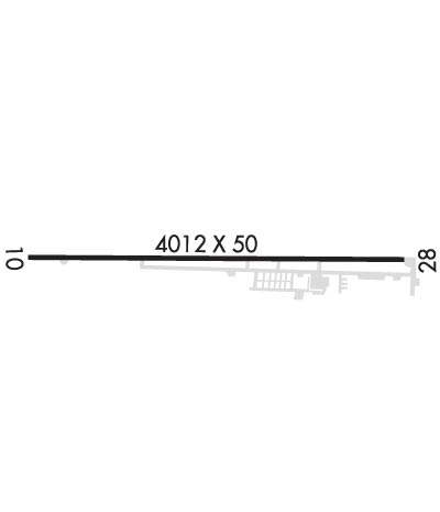
    Runway Identifications
    Runway Identification: 10/28
    Length: 4012 ft
    Width: 50 ft
    Surface: ASPHALT-FAIR CONDITION
    Edge lights: Medium Intensity

    Treatment: NONE

     Runway: 10   Runway: 28
    Mag heading: 98°Mag heading: 278°
    Rwy Slope: 1.44% UpRwy Slope: -1.44% Down
    Approach: Approach:
    Pattern: Left TrafficPattern: Left Traffic
    Markings: NONPRECISION INSTRUMENTMarkings: NONPRECISION INSTRUMENT
    Marking Condition: GOODMarking Condition: GOOD
    Arresting Dev: Arresting Dev:
    Lat & Long: N4057.7  W08041.1Lat. & Long.: N4057.7  W08040.2
    Elev: 1012.0 ft. MSLElev: 1069.6 ft. MSL
    TCH: TCH:
    Visual Glide Path: Visual Glide Path: 3.75 degrees
    Displaced Threshold: 348 feetDisplaced Threshold: 259 feet
    Touchdown Zone: YESTouchdown Zone: YES
    Touchdown Elev.: 1050.5 feetTouchdown Elev.: 1063.3 feet
    Visual Glide Slope: 2-Light PAPI on LEFT side of RunwayVisual Glide Slope: 2-Light PAPI on LEFT side of Runway
    RVR Equipment: RVR Equipment:
    RVV Equipment: NORVV Equipment: NO
    Approach Lights: Approach Lights:
    REIL: YESREIL: YES
    Centerline Lights: NOCenterline Lights: NO
    Touchdown lights: NOTouchdown lights: NO
    Runway Category: Runway with a Non-precision ApproachRunway Category: Runway with a Non-precision Approach
    Declared Distances: Declared Distances:
    Obstructions: TREESObstructions: TREES
    Marked: NOT Marked/LightedMarked: NOT Marked/Lighted
    Clearance slope: 1:1; APCH RATIO 0:1 DUE TO NMRS TREES, 200 FT DIST, 130 FT L/R.Clearance slope: 1:1; APCH RATIO 0:1 TO DTHR DUE TO 18 FT ROAD, 163 FT DIST, 0 FT B; 5 FT FENCE, 140 FT DIST, 0 FT B; +25 FT HNGR, 45-100 FT DIST, 207 FT L.
    Obstruction height: 85 feet AGLObstruction height: 90 feet AGL
    Dist. from runway: 215 feetDist. from runway: 201 feet
    Centerline offset: 225 right of centerlineCenterline offset: 225 feet left of centerline
    Comments: NMRS LRG TREES, 200 FT DIST, 130 FT L/R.Comments: 18 FT ROAD, 163-200 FT DIST, 0 FT B; 5 FT FENCE, 140 FT DIST, 0 FT B; +25 FT HNGR, 45-100 FT DIST, 207 FT L.
    C:8/P: