Approach Charts
| FltPlan does not have IFR approach charts available for K4G3. |
Current Weather/Notams (Metars, TAFs, Notams, NWS Forecast, PIREPS, and nearby weather)
Customs Information Send updates to Support@FltPlan.com
Customs Not Available
Database effective 05/16/2024
Airport Diagram might not be current.
|
| Facility Name: | MILLER |
| City Name: | ALLIANCE |
| County: | MAHONING |
| State abbrev: | OH |
| State Name: | OHIO |
| | |
| Ownership: | PRIVATELY OWNED |
| Use: | OPEN TO THE PUBLIC |
| Owner's Name: | GROVER MATTHEWS |
| Address: | 1286 ADAMS ST |
| | FAIRBORN, OH 45324-5505 |
| Owner's Phone: | 270-863-1799 |
| | |
| Manager's Name: | GROVER MATTHEWS; GCMLLM1963@GMAIL.COM. |
| Address: | 1286 ADAMS ST; ARPT PHYS ADS: 20388 N BENTON WEST RD, NORTH BENTON, OH 44449-9636. |
| | FAIRBORN, OH 45324-5505 |
| Phone: | 270-863-1799 |
| | |
| FAA Region: | GREAT LAKES |
| FAA Field Office: | DET |
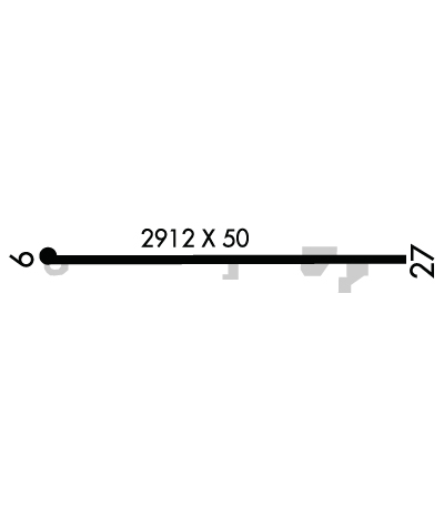
Runway Identifications
Runway Identification: 09/27Length: 2912 ft
Width: 50 ft
Surface: ASPHALT-FAIR CONDITION
Edge lights: Treatment: NONE
| | Runway: 09 | | Runway: 27 |
| Mag heading: | 95° | Mag heading: | 275° |
| Rwy Slope: | .37% Up | Rwy Slope: | -.37% Down |
| Approach: | | Approach: | |
| Pattern: | Left Traffic | Pattern: | Left Traffic |
| Markings: | BASIC | Markings: | BASIC |
| Marking Condition: | FAIR | Marking Condition: | FAIR |
| Arresting Dev: | | Arresting Dev: | |
| Lat & Long: | N4058.9 W08102.8 | Lat. & Long.: | N4058.9 W08102.2 |
| Elev: | 1056.4 ft. MSL | Elev: | 1067.1 ft. MSL |
| TCH: | | TCH: | |
| Visual Glide Path: | | Visual Glide Path: | |
| Displaced Threshold: | No | Displaced Threshold: | No |
| Touchdown Zone: | YES | Touchdown Zone: | YES |
| Touchdown Elev.: | 1071.1 feet | Touchdown Elev.: | 1071.1 feet |
| Visual Glide Slope: | | Visual Glide Slope: | |
| RVR Equipment: | | RVR Equipment: | |
| RVV Equipment: | NO | RVV Equipment: | NO |
| Approach Lights: | | Approach Lights: | |
| REIL: | NO | REIL: | NO |
| Centerline Lights: | NO | Centerline Lights: | NO |
| Touchdown lights: | NO | Touchdown lights: | NO |
| Runway Category: | Runway with a Visual Approach | Runway Category: | Runway with a Visual Approach |
| Declared Distances: | | Declared Distances: | |
| Obstructions: | TREES | Obstructions: | TREES |
| Marked: | NOT Marked/Lighted | Marked: | NOT Marked/Lighted |
| Clearance slope: | 7:1 | Clearance slope: | 2:1 |
| Obstruction height: | 110 feet AGL | Obstruction height: | 75 feet AGL |
| Dist. from runway: | 1000 feet | Dist. from runway: | 400 feet |
| Centerline offset: | 125 right of centerline | Centerline offset: | 60 feet right of centerline |
| Comments: | 58 FT TREES, 0-40 FT DIST, 110 FT R. | Comments: | 50 FT TREES, 132 FT DIST, 120 FT R. |

