Click here for more info on on SMS!

K4D0

ABRAMS MUNI
GRAND LEDGE
MI
Time Zone: Eastern
Lat: N 4246.5
Long: W 08444.0
Elev: 841
Var: +05
Longest Runway: 3200
CTAF: 122.7

FBO & Flight Services info for K4D0

FBOs: Update your Fuel Prices
We are a privately owned company under the same ownership since 1991. As the Fixed Based Operator (FBO) for Abrams Municipal Airport in Grand Ledge, Michigan, we provide a full range of professionally staffed aviation services.
Ph: 517-627-9557
-
Freq: 122.7WebsiteE-Mail
                                  
Service
Jet
100LL
SAF
MoGas
Full  5.95    Last Update: 04/20/2024 11:17

Self        
Misc. Info: Address: 16815 WRIGHT RD   GRAND LEDGE, MI 48837

If you are an FBO, call 1-203-262-1700 to update your info or email: FltPlan.Advertising@garmin.com
Advertise your FBO on FltPlan.com

Runway & Approach Info for K4D0
Rwy
Length
Land Dist**
Approach*
  Rwy
Length
Land Dist**
Approach*
09
3200x75  3200'          
 
  
27
  3200x75  3200'          
 
18
2560x120  2172'          
 
  
36
  2560x120  2173'          
 
 * only ILS, LOC, LDA, and SDF approaches to a specific runway are shown
** For any Declared Landing Distance Available, please see A/FD or Approach plates
Runway Weight Capability (lbs.) Help
Runway IDSingle WheelDouble WheelDouble Tandem WheelDual Double Wheel
09/27N/AN/AN/AN/A
18/36N/AN/AN/AN/A
These numbers are Advisory and are not limits.   The Airport Manager should have more accurate Weight Limits
Approach Charts
Approaches    
Current Weather/Notams
Customs Information Send updates to Support@FltPlan.com
Customs Not Available
Database effective 05/16/2024
Airport Diagram of K4D0
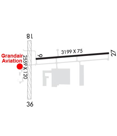
Airport Diagram might not be current.

Facility Name: ABRAMS MUNI
City Name: GRAND LEDGE
County: CLINTON
State abbrev: MI
State Name: MICHIGAN
   
Ownership: PUBLICLY OWNED
Use: OPEN TO THE PUBLIC
Owner's Name: CITY OF GRAND LEDGE
Address: 310 GREENWOOD ST
 GRAND LEDGE, MI 48837-1651
Owner's Phone: 517-627-2149
  
Manager's Name: ADAM SMITH, CITY MGR
Address: 310 GREENWOOD ST
 GRAND LEDGE, MI 48837-1651
Phone: 517-627-2149; EXTN 111.
   
FAA Region: GREAT LAKES
FAA Field Office: DET


Sunrise / Sunset times for ABRAMS MUNI

DateSunriseSunset
04/23/24 Tuesday6:4420:31
04/24/24 Wednesday6:4220:32
04/25/24 Thursday6:4120:34
04/26/24 Friday6:3920:35
04/27/24 Saturday6:3820:36
04/28/24 Sunday6:3620:37
04/29/24 Monday6:3520:38
04/30/24 Tuesday6:3420:39
05/01/24 Wednesday6:3220:40
05/02/24 Thursday6:3120:41
05/03/24 Friday6:3020:43
05/04/24 Saturday6:2820:44
05/05/24 Sunday6:2720:45
05/06/24 Monday6:2620:46

Airport Facilities

Airport Attendance ScheduleMON&FRI 0800-1630, TUE-THU 0800-0000
Airport Status OPERATIONAL (This Status can change at any time - please check NOTAMS)
Airport Lighting ScheduleACTVT REIL RWY 27; PAPI RWY 09 & 27; MIRL RWY 09/27 - CTAF.
Airport Storage AvailableTie Downs, Hanger
Extra Services AvailableCharter, Flight Instruction, Aircraft Rental
Wind IndicatorYES - (lighted)
Control TowerNO
CTAF Frequency122.700
Unicom Frequency122.700
Rotating Beacon ColorWG
Segmented CircleYES
Landing FeeNO

Airport Inspection Data

Airport InspectedSTATE - performed by STATE AERONAUTICAL PERSONNEL
Inspection Date07/15/2021

Airport Services

Type of Fuel AvailableGrade 100LL
Airframe Repair ServiceMAJOR
Power Plant Repair ServiceMAJOR

Geographic Data

LatitudeN4246.5
LongitudeW08444.0 (ESTIMATED)
Arpt Elevation841ft (SURVEYED)
Magnetic Variation05W
2 miles Nof GRAND LEDGE
Traffic Pattern Altitude
Sectional ChartDETROIT

Aircraft Data

Operations (Reported)YearlyAvg. Daily
General Aviation Transient 500014
General Aviation Local 500014
Air Taxi 00
Commerical 00
Commuter 00
Military 23006
Aircraft based on Field
General Aviation Singles 22
General Aviation Multi 2
Jet Aircraft 0
General Aviation Helicopters 0
Military Aircraft 19
Gliders 0
Ultralights 0

FAA Services

FSS on field NO
FSS tie-in LANSING
FSS Phone 1-800-WX-BRIEF
Who issues Notams LAN
Notam D service at airport YES
ARTCC Name CLEVELAND

Federal Status

Airport Certification
Aircraft Rescue & Firefighting IndexNone
Airport of EntryNo
Custom Landing RightsNo
Joint Civil/MilitaryNo
Military Landing rightsYES

Federal Agreements

NATIONAL PLAN OF INTEGRATED AIRPORT SYSTEMS (NPIAS)
GRANT AGREEMENTS UNDER FAAP/ADAP/AIP
ASSURANCES PURSUANT TO TITLE VI, CIVIL RIGHTS ACT OF 1964

Remarks

MILITARY: RNG: NO FIXED WING & LTD ROTARY WING PRKG ON AASF RAMP.
CTC AIRFIELD OPS ON 41.85/122.7/241.0.
FOR CD CTC GREAT LAKES APCH AT 269-459-3345, WHEN APCH CLSD CTC CLEVELAND ARTCC AT 440-774-0224/0490.
TPA 1900 FT MSL FOR FW; 1700 FT MSL FOR HEL.
INTSV NG HELICOPTER TRG ON & INVOF ARPT. HELICOPTERS AVOID FLOW OF FIXED WING ACFT PER 14 CFR 91.126.
EXIT RWY 18/36 ONLY AT TWYS.
RWY 18/36 CLSD TO FIXED WING ACFT NOV-APR; SOFT IN SPRING.
AVOID OVERFLIGHT OF GRAND LEDGE BLW 2000 FT.
Airport Communications & Frequencies:
CTAF Frequency:
122.700
Unicom Frequency:
122.700
Remarks
  • APCH/DEP SVC PRVDD BY CLEVELAND ARTCC (ZOB) ON FREQS 126.75/348.75 (FLINT RCAG) WHEN GREAT LAKES APCH CTL CLSD.
  • GREAT LAKES Primary Approach Frequencies:  
    118.65
    226.4
    GREAT LAKES Primary Departure Frequencies:  
    118.65
    226.4
    Runway Identifications
    Runway Identification: 09/27
    Length: 3200 ft
    Width: 75 ft
    Surface: ASPHALT-GOOD CONDITION
    Edge lights: Medium Intensity

    Treatment: NONE

     Runway: 09   Runway: 27
    Mag heading: 91°Mag heading: 271°
    Rwy Slope: .30% UpRwy Slope: -.30% Down
    Approach: Approach:
    Pattern: Left TrafficPattern: Left Traffic
    Markings: NONPRECISION INSTRUMENTMarkings: NONPRECISION INSTRUMENT
    Marking Condition: FAIRMarking Condition: FAIR
    Arresting Dev: Arresting Dev:
    Lat & Long: N4246.5  W08444.2Lat. & Long.: N4246.6  W08443.4
    Elev: 830.5 ft. MSLElev: 840.0 ft. MSL
    TCH: 34 ft. AGLTCH: 35 ft. AGL
    Visual Glide Path: 4.00 degreesVisual Glide Path: 4.00 degrees
    Displaced Threshold: NoDisplaced Threshold: No
    Touchdown Zone: YESTouchdown Zone: YES
    Touchdown Elev.: 841.1 feetTouchdown Elev.: 841.1 feet
    Visual Glide Slope: 4-Light PAPI on LEFT side of Runway; UNUSBL BYD 5 DEGS RIGHT OF CNTRLN.Visual Glide Slope: 2-Light PAPI on LEFT side of Runway
    RVR Equipment: RVR Equipment:
    RVV Equipment: NORVV Equipment: NO
    Approach Lights: Approach Lights:
    REIL: NOREIL: YES
    Centerline Lights: NOCenterline Lights: NO
    Touchdown lights: NOTouchdown lights: NO
    Runway Category: Runway with a Non-precision ApproachRunway Category: Runway with a Visual Approach
    Declared Distances: Declared Distances:
    Obstructions: TREEObstructions: BRUSH
    Marked: NOT Marked/LightedMarked: NOT Marked/Lighted
    Clearance slope: 18:1Clearance slope: 13:1
    Obstruction height: 43 feet AGLObstruction height: 11 feet AGL
    Dist. from runway: 996 feetDist. from runway: 353 feet
    Centerline offset: 338 left of centerlineCenterline offset: 202 feet left of centerline
    Comments: Comments: 4 FT HILL, 30-199 FT DIST, 125-250 FT L.
    Runway Identification: 18/36
    Length: 2560 ft
    Width: 120 ft
    Surface: GRASS-FAIR CONDITION
    Edge lights:

    Treatment: NONE

     Runway: 18   Runway: 36
    Mag heading: 185°Mag heading:
    Rwy Slope: .33% UpRwy Slope: -.33% Down
    Approach: Approach:
    Pattern: Left TrafficPattern: Left Traffic
    Markings: Markings:
    Marking Condition: DTHR MKD WITH 3 FT YELLOW CONES.Marking Condition: DTHR MKD WITH 3 FT YELLOW CONES.
    Arresting Dev: Arresting Dev:
    Lat & Long: N4246.6  W08444.2Lat. & Long.: N4246.2  W08444.2
    Elev: 828.3 ft. MSLElev: 836.8 ft. MSL
    TCH: TCH:
    Visual Glide Path: Visual Glide Path:
    Displaced Threshold: 388 feetDisplaced Threshold: 387 feet
    Touchdown Zone: YESTouchdown Zone: YES
    Touchdown Elev.: 836.9 feetTouchdown Elev.: 835.4 feet
    Visual Glide Slope: Visual Glide Slope:
    RVR Equipment: RVR Equipment:
    RVV Equipment: NORVV Equipment: NO
    Approach Lights: Approach Lights:
    REIL: NOREIL: NO
    Centerline Lights: NOCenterline Lights: NO
    Touchdown lights: NOTouchdown lights: NO
    Runway Category: Runway with a Visual ApproachRunway Category: Runway with a Visual Approach
    Declared Distances: Declared Distances:
    Obstructions: TREESObstructions: ROAD
    Marked: NOT Marked/LightedMarked: NOT Marked/Lighted
    Clearance slope: 6:1; APCH RATIO 50:1 AT DTHR.Clearance slope: 2:1; APCH RATIO 24:1 AT DTHR.
    Obstruction height: 8 feet AGLObstruction height: 17 feet AGL
    Dist. from runway: 50 feetDist. from runway: 45 feet
    Centerline offset: 130 right of centerlineCenterline offset:
    Comments: Comments:
    C:2/P: