| ||||||||||||||||||||||||||||||||||||||||||||||||||||||||||||||||||||
| ||||||||||||||||||||||||||||||||||||||||||||||||||||||||||||||||||||
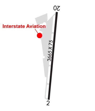
| Rwy | Rwy | |||||||
| 3665x75 | 3665' | 3665x75 | 3665' | |||||
| Runway ID | Single Wheel | Double Wheel | Double Tandem Wheel | Dual Double Wheel |
| 02/20 | 25,000 | N/A | N/A | N/A |
| H1 | N/A | N/A | N/A | N/A |
| These numbers are Advisory and are not limits. The Airport Manager should have more accurate Weight Limits | ||||
 Airport Diagram might not be current. | |
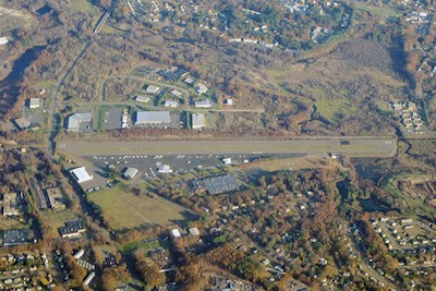
| Facility Name: | ROBERTSON FLD |
| City Name: | PLAINVILLE |
| County: | HARTFORD |
| State abbrev: | CT |
| State Name: | CONNECTICUT |
| Ownership: | PUBLICLY OWNED |
| Use: | OPEN TO THE PUBLIC |
| Owner's Name: | TOWN OF PLAINVILLE |
| Address: | 1 CENTRAL SQUARE |
| PLAINVILLE, CT 06062 | |
| Owner's Phone: | 860-793-0221 |
| Manager's Name: | NICHOLAS SCATA |
| Address: | 62 JOHNSON AVE |
| PLAINVILLE, CT 06062 | |
| Phone: | 860-747-5519 |
| FAA Region: | NEW ENGLAND |
| FAA Field Office: | NONE |
| Date | Sunrise | Sunset |
|---|---|---|
| 04/18/24 Thursday | 6:06 | 19:36 |
| 04/19/24 Friday | 6:04 | 19:37 |
| 04/20/24 Saturday | 6:03 | 19:38 |
| 04/21/24 Sunday | 6:01 | 19:40 |
| 04/22/24 Monday | 6:00 | 19:41 |
| 04/23/24 Tuesday | 5:58 | 19:42 |
| 04/24/24 Wednesday | 5:57 | 19:43 |
| 04/25/24 Thursday | 5:55 | 19:44 |
| 04/26/24 Friday | 5:54 | 19:45 |
| 04/27/24 Saturday | 5:53 | 19:46 |
| 04/28/24 Sunday | 5:51 | 19:47 |
| 04/29/24 Monday | 5:50 | 19:48 |
| 04/30/24 Tuesday | 5:48 | 19:49 |
| 05/01/24 Wednesday | 5:47 | 19:50 |
| Airport Attendance Schedule | MON-FRI 0800-1900, SAT-SUN 0800-1800 |
| Airport Status | OPERATIONAL (This Status can change at any time - please check NOTAMS) |
| Airport Lighting Schedule | ACTVT MIRL RWY 02/20 - CTAF. REIL RWYS 02 & 20 OPR WHEN RWY LGTS ON HIGH INTST. |
| Airport Storage Available | Tie Downs, Hanger |
| Extra Services Available | Charter, Flight Instruction, Aircraft Rental |
| Wind Indicator | YES - (lighted) |
| Control Tower | NO |
| CTAF Frequency | 122.800 |
| Unicom Frequency | 122.800 |
| Rotating Beacon Color | WG |
| Segmented Circle | NO |
| Landing Fee | NO; LDG FEE FOR COML AND CORPORATE ACFT ONLY. |
| Airport Inspected | STATE - performed by PRIVATE CONTRACT PERSONNEL |
| Inspection Date | 08/17/2022 |
| Type of Fuel Available | Grade 100LL, JET A (freeze point -40C) |
| Airframe Repair Service | MAJOR |
| Power Plant Repair Service | MAJOR |
| Latitude | N4141.4 |
| Longitude | W07251.9 (ESTIMATED) |
| Arpt Elevation | 201ft (SURVEYED) |
| Magnetic Variation | 14W |
| 2 miles N | of PLAINVILLE |
| Traffic Pattern Altitude | 800; TPA: 800 FT FOR ACFT LESS THAN 12500 LBS, 1300 FT FOR ACFT 12500 LBS & ABV. |
| Sectional Chart | NEW YORK |
| Operations (Reported) | Yearly | Avg. Daily |
|---|---|---|
| General Aviation Transient | 11000 | 30 |
| General Aviation Local | 11000 | 30 |
| Air Taxi | 550 | 2 |
| Commerical | 0 | 0 |
| Commuter | 0 | 0 |
| Military | 60 | 0 |
| Aircraft based on Field | |
|---|---|
| General Aviation Singles | 41 |
| General Aviation Multi | 3 |
| Jet Aircraft | 0 |
| General Aviation Helicopters | 5 |
| Military Aircraft | 0 |
| Gliders | 0 |
| Ultralights | 0 |
| FSS on field | NO |
| FSS tie-in | BRIDGEPORT |
| FSS Phone | 1-800-WX-BRIEF |
| Who issues Notams | BDR |
| Notam D service at airport | YES |
| ARTCC Name | BOSTON |
| Airport Certification | |
| Aircraft Rescue & Firefighting Index | None |
| Airport of Entry | No |
| Custom Landing Rights | No |
| Joint Civil/Military | No |
| Military Landing rights | No |
| NATIONAL PLAN OF INTEGRATED AIRPORT SYSTEMS (NPIAS) |
| NOISE ABATEMENT PROCS IN EFCT. CTC 1-800-573-5519 OR 860-747-5519 FOR DTLS. |
| FOR CD CTC YANKEE APCH AT 860-386-3597. |
| CTN DEER & BIRDS ON & INVOF ARPT. |
Airport Communications & Frequencies:
| |||||||||||||||||||
| Runway: 02 | Runway: 20 | ||
| Mag heading: | 19° | Mag heading: | 199° |
| Rwy Slope: | .35% Up | Rwy Slope: | -.35% Down |
| Approach: | Approach: | ||
| Pattern: | Left Traffic | Pattern: | Left Traffic |
| Markings: | NONPRECISION INSTRUMENT | Markings: | NONPRECISION INSTRUMENT |
| Marking Condition: | GOOD | Marking Condition: | GOOD |
| Arresting Dev: | Arresting Dev: | ||
| Lat & Long: | N4141.1 W07251.9 | Lat. & Long.: | N4141.7 W07251.8 |
| Elev: | 188.6 ft. MSL | Elev: | 201.6 ft. MSL |
| TCH: | TCH: | ||
| Visual Glide Path: | Visual Glide Path: | ||
| Displaced Threshold: | No | Displaced Threshold: | No |
| Touchdown Zone: | YES | Touchdown Zone: | YES |
| Touchdown Elev.: | 201.1 feet | Touchdown Elev.: | 201.8 feet |
| Visual Glide Slope: | Visual Glide Slope: | ||
| RVR Equipment: | RVR Equipment: | ||
| RVV Equipment: | NO | RVV Equipment: | NO |
| Approach Lights: | Approach Lights: | ||
| REIL: | YES | REIL: | YES |
| Centerline Lights: | NO | Centerline Lights: | NO |
| Touchdown lights: | NO | Touchdown lights: | NO |
| Runway Category: | Runway with a Visual Approach | Runway Category: | Runway with a Visual Approach |
| Declared Distances: | Declared Distances: | ||
| Obstructions: | TREES | Obstructions: | TREES |
| Marked: | NOT Marked/Lighted | Marked: | NOT Marked/Lighted |
| Clearance slope: | 2:1 | Clearance slope: | 1:1 |
| Obstruction height: | 17 feet AGL | Obstruction height: | 50 feet AGL |
| Dist. from runway: | 250 feet | Dist. from runway: | 240 feet |
| Centerline offset: | 67 left of centerline | Centerline offset: | 105 feet right of centerline |
| Comments: | 10 FT BRUSH, 15 FT DSTC, 90 FT L. | Comments: |