Click here for more info on on SMS!

K4B0

SOUTH ALBANY
SOUTH BETHLEHEM
NY
Time Zone: Eastern
Lat: N 4233.6
Long: W 07350.0
Elev: 196
Var: +14
Longest Runway: 2853
CTAF: 122.9

FBO & Flight Services info for K4B0

FBOs: Update your Fuel Prices
Providing high quality fuel and services to you and your customers, from Phillips 66 Aviation.
Ph: 518-767-9189
-
Freq: 122.9Website-
Service
Jet
100LL
SAF
MoGas
Fuel Avail: PRIST Premixed
Full        Last Update: 03/23/2024 10:33

Self6.455.55    
Misc. Info: Address: 6 OLD SCHOOL RD   SELKIRK, NY 12158

If you are an FBO, call 1-203-262-1700 to update your info or email: FltPlan.Advertising@garmin.com
Advertise your FBO on FltPlan.com

Runway & Approach Info for K4B0
Rwy
Length
Land Dist**
Approach*
  Rwy
Length
Land Dist**
Approach*
01
2853x60  2703'          
 
  
19
  2853x60  2729'          
 
 * only ILS, LOC, LDA, and SDF approaches to a specific runway are shown
** For any Declared Landing Distance Available, please see A/FD or Approach plates
Runway Weight Capability (lbs.) Help
Runway IDSingle WheelDouble WheelDouble Tandem WheelDual Double Wheel
01/19N/AN/AN/AN/A
These numbers are Advisory and are not limits.   The Airport Manager should have more accurate Weight Limits
Approach Charts
Approaches    
Current Weather/Notams
Customs Information Send updates to Support@FltPlan.com
Customs Not Available
Database effective 04/18/2024
Airport Diagram of K4B0
Airport Diagram might not be current.

Facility Name: SOUTH ALBANY
City Name: SOUTH BETHLEHEM
County: ALBANY
State abbrev: NY
State Name: NEW YORK
   
Ownership: PRIVATELY OWNED
Use: OPEN TO THE PUBLIC
Owner's Name: SOUTH ALBANY CORP
Address: 6 OLD SCHOOL ROAD
 SELKIRK, NY 12158
Owner's Phone: (518) 281-5430
  
Manager's Name: TED ZABINSKI
Address: 6 OLD SCHOOL ROAD
 SELKIRK, NY 12158
Phone: (518) 281-5430
   
FAA Region: EASTERN
FAA Field Office: NYC


Sunrise / Sunset times for SOUTH ALBANY

DateSunriseSunset
04/19/24 Friday6:0719:43
04/20/24 Saturday6:0519:44
04/21/24 Sunday6:0419:45
04/22/24 Monday6:0219:46
04/23/24 Tuesday6:0119:47
04/24/24 Wednesday5:5919:48
04/25/24 Thursday5:5819:49
04/26/24 Friday5:5619:51
04/27/24 Saturday5:5519:52
04/28/24 Sunday5:5319:53
04/29/24 Monday5:5219:54
04/30/24 Tuesday5:5019:55
05/01/24 Wednesday5:4919:56
05/02/24 Thursday5:4819:57

Airport Facilities

Airport Attendance ScheduleNOV-MAR 7 Days A Week 0800-1600, APR-OCT 7 Days A Week 0600-2100
Airport Status OPERATIONAL (This Status can change at any time - please check NOTAMS)
Airport Lighting ScheduleACTVT LIRL RWY 01/19; WDI LGT - CTAF.
Airport Storage AvailableHanger
Extra Services AvailableAir Ambulance, Flight Instruction
Wind IndicatorYES - (lighted)
Control TowerNO
CTAF Frequency122.900
Unicom Frequency
Rotating Beacon Color
Segmented CircleNO
Landing FeeNO

Airport Inspection Data

Airport InspectedSTATE - performed by STATE AERONAUTICAL PERSONNEL
Inspection Date05/25/2022

Airport Services

Type of Fuel AvailableGrade 100LL, JET A (freeze point -40C)
Airframe Repair ServiceMAJOR
Power Plant Repair ServiceMAJOR

Geographic Data

LatitudeN4233.6
LongitudeW07350.0 (ESTIMATED)
Arpt Elevation195ft (SURVEYED)
Magnetic Variation14W
2 miles Nof SOUTH BETHLEHEM
Traffic Pattern Altitude
Sectional ChartNEW YORK

Aircraft Data

Operations (Reported)YearlyAvg. Daily
General Aviation Transient 798022
General Aviation Local 2000055
Air Taxi 00
Commerical 00
Commuter 00
Military 5201
Aircraft based on Field
General Aviation Singles 21
General Aviation Multi 2
Jet Aircraft 0
General Aviation Helicopters 0
Military Aircraft 0
Gliders 0
Ultralights 0

FAA Services

FSS on field NO
FSS tie-in BURLINGTON
FSS Phone 1-800-WX-BRIEF
Who issues Notams BTV
Notam D service at airport YES
ARTCC Name BOSTON

Federal Status

Airport Certification
Aircraft Rescue & Firefighting IndexNone
Airport of EntryNo
Custom Landing RightsNo
Joint Civil/MilitaryNo
Military Landing rightsNo

Federal Agreements

NATIONAL PLAN OF INTEGRATED AIRPORT SYSTEMS (NPIAS)

Remarks

ARPT CLSD TO ACFT OVER 12500 LBS.
BIRDS ON AND INVOF ARPT.
HEL NOISE ABATEMENT PROC IN EFCT. VFR DEP MNTN RWY HDG TIL REACHING 500 FT AGL. AVOID ARR AND DEP TO/FM THE WEST.
17 FT RAILROAD ACRS CNTRLN 200 FT S OF RWY 01
FOR CD CTC ALBANY APCH AT 518-862-2299.
Airport Communications & Frequencies:
CTAF Frequency:
122.900
ALBANY Primary Approach Frequencies:  
118.05
263.075
ALBANY Primary Departure Frequencies:  
118.05
263.075
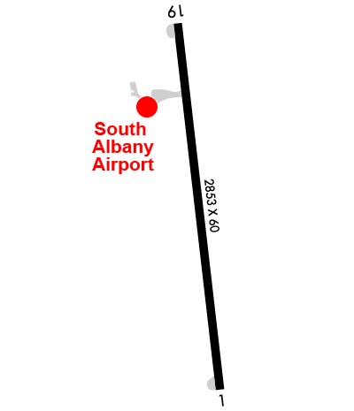
Runway Identifications
Runway Identification: 01/19
Length: 2853 ft
Width: 60 ft
Surface: ASPHALT-GOOD CONDITION
Edge lights: Low Intensity

Treatment: NONE

 Runway: 01   Runway: 19
Mag heading: Mag heading: 187°
Rwy Slope: .39% UpRwy Slope: -.39% Down
Approach: Approach:
Pattern: Left TrafficPattern: Left Traffic
Markings: NONPRECISION INSTRUMENTMarkings: NONPRECISION INSTRUMENT
Marking Condition: GOODMarking Condition: GOOD
Arresting Dev: Arresting Dev:
Lat & Long: N4233.4  W07350.0Lat. & Long.: N4233.9  W07350.1
Elev: 184.3 ft. MSLElev: 195.3 ft. MSL
TCH: TCH:
Visual Glide Path: Visual Glide Path:
Displaced Threshold: 150 feetDisplaced Threshold: 124 feet
Touchdown Zone: YESTouchdown Zone: YES
Touchdown Elev.: 195.3 feetTouchdown Elev.: 195.3 feet
Visual Glide Slope: Visual Glide Slope:
RVR Equipment: TOUCHDOWNRVR Equipment: ROLLOUT
RVV Equipment: NORVV Equipment: NO
Approach Lights: Approach Lights:
REIL: NOREIL: NO
Centerline Lights: NOCenterline Lights: NO
Touchdown lights: NOTouchdown lights: NO
Runway Category: Runway with a Non-precision ApproachRunway Category: Runway with a Non-precision Approach
Declared Distances: Declared Distances:
Obstructions: FENCEObstructions: ROAD
Marked: NOT Marked/LightedMarked: NOT Marked/Lighted
Clearance slope: 1:1; RWY 1 CLNC SLOPE 13:1 TO DTHR DUE TO +27 FT TREE, 364 FT FM DTHR, 100 FT LEFT.Clearance slope: 6:1; CLNCE SLOPE 12:1 TO DTHR DUE TO +44 FT TREE, 535 FT FM DTHR, 177 FT L.
Obstruction height: 27 feet AGLObstruction height: 34 feet AGL
Dist. from runway: 214 feetDist. from runway: 420 feet
Centerline offset: 100 left of centerlineCenterline offset: 137 feet left of centerline
Comments: +48 FT TREE, 90 FT FM RWY, 223 FT L. +26 FT TREE, 58 FT FM RWY, 144 FT L. +5 FT FENCE 125 FT R AND 115 FT L.Comments: +38 FT POLE, 182 FT FM RWY, 170 FT L. +50 FT POLE, 25 FT FM RWY, 194 FT R. +15 FT ROAD, 105 FT R.
C:1/P: