Current Weather/Notams (Metars, TAFs, Notams, NWS Forecast, PIREPS, and nearby weather)
Customs Information Send updates to Support@FltPlan.com
Customs Not Available
Database effective 05/16/2024
Airport Diagram might not be current.
|
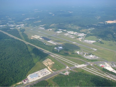
| Facility Name: | ISBELL FLD |
| City Name: | FORT PAYNE |
| County: | DE KALB |
| State abbrev: | AL |
| State Name: | ALABAMA |
| | |
| Ownership: | PUBLICLY OWNED |
| Use: | OPEN TO THE PUBLIC |
| Owner's Name: | CITY OF FORT PAYNE |
| Address: | 100 ALABAMA AVE NW |
| | FORT PAYNE, AL 35967 |
| Owner's Phone: | 256-845-1524 |
| | |
| Manager's Name: | BARRY STONE |
| Address: | 2200 TERMINAL DRIVE NW |
| | FORT PAYNE, AL 35968 |
| Phone: | 256-845-9129 |
| | |
| FAA Region: | SOUTHERN |
| FAA Field Office: | JAN |
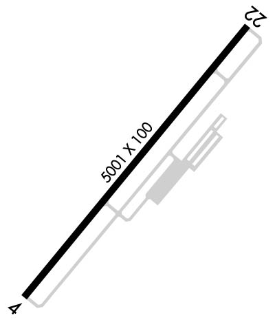
Runway Identifications
Runway Identification: 04/22Length: 5001 ft
Width: 100 ft
Surface: ASPHALT-GOOD CONDITION
Edge lights: Medium IntensityTreatment: GROOVED
| | Runway: 04 | | Runway: 22 |
| Mag heading: | 44° | Mag heading: | 224° |
| Rwy Slope: | .35% Up | Rwy Slope: | -.35% Down |
| Approach: | | Approach: | |
| Pattern: | Left Traffic | Pattern: | Left Traffic |
| Markings: | NONPRECISION INSTRUMENT | Markings: | NONPRECISION INSTRUMENT |
| Marking Condition: | FAIR | Marking Condition: | FAIR |
| Arresting Dev: | | Arresting Dev: | |
| Lat & Long: | N3428.1 W08543.6 | Lat. & Long.: | N3428.7 W08543.0 |
| Elev: | 855.8 ft. MSL | Elev: | 873.1 ft. MSL |
| TCH: | 58 ft. AGL | TCH: | 38 ft. AGL |
| Visual Glide Path: | 4.00 degrees | Visual Glide Path: | 3.00 degrees |
| Displaced Threshold: | No | Displaced Threshold: | No |
| Touchdown Zone: | YES | Touchdown Zone: | YES |
| Touchdown Elev.: | 876.7 feet | Touchdown Elev.: | 876.7 feet |
| Visual Glide Slope: | 4-Light PAPI on LEFT side of Runway | Visual Glide Slope: | 4-Light PAPI on RIGHT side of Runway |
| RVR Equipment: | | RVR Equipment: | |
| RVV Equipment: | NO | RVV Equipment: | NO |
| Approach Lights: | | Approach Lights: | |
| REIL: | YES | REIL: | YES |
| Centerline Lights: | NO | Centerline Lights: | NO |
| Touchdown lights: | NO | Touchdown lights: | NO |
| Runway Category: | Runway with a Non-precision Approach having visibility minimums greater than 3/4 mile | Runway Category: | Runway with a Non-precision Approach having visibility minimums greater than 3/4 mile |
| Declared Distances: | | Declared Distances: | |
| Obstructions: | TREE | Obstructions: | TREE |
| Marked: | LIGHTED | Marked: | NOT Marked/Lighted |
| Clearance slope: | 22:1 | Clearance slope: | 22:1 |
| Obstruction height: | 60 feet AGL | Obstruction height: | 97 feet AGL |
| Dist. from runway: | 1528 feet | Dist. from runway: | 2369 feet |
| Centerline offset: | 194 right of centerline | Centerline offset: | 340 feet left of centerline |
| Comments: | | Comments: | |