Approach Charts
| FltPlan does not have IFR approach charts available for K48S. |
Current Weather/Notams (Metars, TAFs, Notams, NWS Forecast, PIREPS, and nearby weather)
Customs Information Send updates to Support@FltPlan.com
Customs Not Available
Database effective 04/18/2024
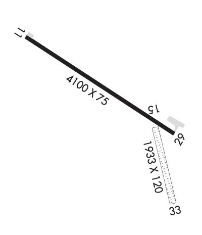
Airport Diagram might not be current.
|
| Facility Name: | HARLEM |
| City Name: | HARLEM |
| County: | BLAINE |
| State abbrev: | MT |
| State Name: | MONTANA |
| | |
| Ownership: | PUBLICLY OWNED |
| Use: | OPEN TO THE PUBLIC |
| Owner's Name: | BLAINE CO-CITY OF HARLEM |
| Address: | BLAINE COUNTY ARPT CMSN |
| | CHINOOK, MT 59523 |
| Owner's Phone: | 406-357-3250 |
| | |
| Manager's Name: | ROD WAGNER |
| Address: | PO BOX 427 |
| | HARLEM, MT 59526 |
| Phone: | (406) 580-7379 |
| | |
| FAA Region: | NORTHWEST MOUNTAIN |
| FAA Field Office: | HLN |
Runway Identifications
Runway Identification: 11/29Length: 4100 ft
Width: 75 ft
Surface: ASPHALT
Edge lights: Medium IntensityTreatment: NONE
| | Runway: 11 | | Runway: 29 |
| Mag heading: | 109° | Mag heading: | 289° |
| Rwy Slope: | -1.05% Down | Rwy Slope: | 1.05% Up |
| Approach: | | Approach: | |
| Pattern: | Left Traffic | Pattern: | Left Traffic |
| Markings: | BASIC | Markings: | BASIC |
| Marking Condition: | GOOD | Marking Condition: | GOOD |
| Arresting Dev: | | Arresting Dev: | |
| Lat & Long: | N4834.3 W10847.0 | Lat. & Long.: | N4833.9 W10846.2 |
| Elev: | 2643.0 ft. MSL | Elev: | 2599.9 ft. MSL |
| TCH: | | TCH: | 35 ft. AGL |
| Visual Glide Path: | | Visual Glide Path: | 3.00 degrees |
| Displaced Threshold: | No | Displaced Threshold: | No |
| Touchdown Zone: | NO | Touchdown Zone: | NO |
| Touchdown Elev.: | | Touchdown Elev.: | |
| Visual Glide Slope: | | Visual Glide Slope: | 2-Light PAPI on LEFT side of Runway |
| RVR Equipment: | | RVR Equipment: | |
| RVV Equipment: | NO | RVV Equipment: | NO |
| Approach Lights: | | Approach Lights: | |
| REIL: | NO | REIL: | NO |
| Centerline Lights: | NO | Centerline Lights: | NO |
| Touchdown lights: | NO | Touchdown lights: | NO |
| Runway Category: | Runway with a Visual Approach | Runway Category: | Runway with a Visual Approach |
| Declared Distances: | | Declared Distances: | |
Runway Identification: 15/33Length: 1933 ft
Width: 120 ft
Surface: GRASS-POOR CONDITION
Edge lights: Treatment: NONE
| | Runway: 15 | | Runway: 33 |
| Mag heading: | 149° | Mag heading: | 329° |
| Rwy Slope: | -.76% Down | Rwy Slope: | .76% Up |
| Approach: | | Approach: | |
| Pattern: | Left Traffic | Pattern: | Left Traffic |
| Markings: | | Markings: | |
| Marking Condition: | MKD WITH WHITE CONES SPACED 200 FT. MOST CONES MISG. | Marking Condition: | |
| Arresting Dev: | | Arresting Dev: | |
| Lat & Long: | N4833.9 W10846.2 | Lat. & Long.: | N4833.6 W10846.1 |
| Elev: | 2601.4 ft. MSL | Elev: | 2586.8 ft. MSL |
| TCH: | | TCH: | |
| Visual Glide Path: | | Visual Glide Path: | |
| Displaced Threshold: | No | Displaced Threshold: | No |
| Touchdown Zone: | NO | Touchdown Zone: | NO |
| Touchdown Elev.: | | Touchdown Elev.: | |
| Visual Glide Slope: | | Visual Glide Slope: | |
| RVR Equipment: | | RVR Equipment: | |
| RVV Equipment: | NO | RVV Equipment: | NO |
| Approach Lights: | | Approach Lights: | |
| REIL: | NO | REIL: | NO |
| Centerline Lights: | NO | Centerline Lights: | NO |
| Touchdown lights: | NO | Touchdown lights: | NO |
| Runway Category: | Runway with a Visual Approach | Runway Category: | Runway with a Visual Approach |
| Declared Distances: | | Declared Distances: | |

