Current Weather/Notams (Metars, TAFs, Notams, NWS Forecast, PIREPS, and nearby weather)
Customs Information Send updates to Support@FltPlan.com
Customs Not Available
Database effective 05/16/2024
Airport Diagram might not be current.
|
| Facility Name: | BRAXTON COUNTY |
| City Name: | SUTTON |
| County: | BRAXTON |
| State abbrev: | WV |
| State Name: | WEST VIRGINIA |
| | |
| Ownership: | PUBLICLY OWNED |
| Use: | OPEN TO THE PUBLIC |
| Owner's Name: | CO CMSN OF BRAXTON |
| Address: | BOX 486 |
| | SUTTON, WV 26601 |
| Owner's Phone: | 304-765-2835 |
| | |
| Manager's Name: | PATRICK O'MALLEY |
| Address: | 106 BIRCH ST |
| | GASAWAY, WV 26624-1102 |
| Phone: | (304) 542-3311 |
| | |
| FAA Region: | EASTERN |
| FAA Field Office: | BKW |
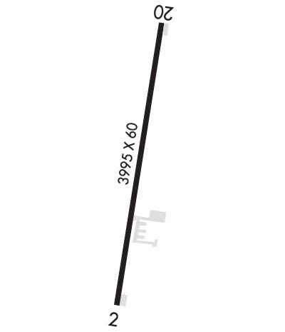
Runway Identifications
Runway Identification: 02/20Length: 3995 ft
Width: 60 ft
Surface: ASPHALT
Edge lights: Medium IntensityTreatment: AGGREGATE FRICTION SEAL COAT
| | Runway: 02 | | Runway: 20 |
| Mag heading: | 16° | Mag heading: | 196° |
| Rwy Slope: | .58% Up | Rwy Slope: | -.58% Down |
| Approach: | | Approach: | |
| Pattern: | Left Traffic | Pattern: | Left Traffic |
| Markings: | BASIC | Markings: | NONPRECISION INSTRUMENT |
| Marking Condition: | POOR; RWY MKGS FADED. | Marking Condition: | POOR; RWY MKGS FADED. |
| Arresting Dev: | | Arresting Dev: | |
| Lat & Long: | N3840.9 W08039.2 | Lat. & Long.: | N3841.6 W08039.1 |
| Elev: | 1252.5 ft. MSL | Elev: | 1275.6 ft. MSL |
| TCH: | | TCH: | 40 ft. AGL |
| Visual Glide Path: | | Visual Glide Path: | 4.00 degrees |
| Displaced Threshold: | 801 feet | Displaced Threshold: | No |
| Touchdown Zone: | YES | Touchdown Zone: | YES |
| Touchdown Elev.: | 1268.0 feet | Touchdown Elev.: | 1275.6 feet |
| Visual Glide Slope: | | Visual Glide Slope: | 2-Light PAPI on LEFT side of Runway; UNUSBL BYD 6 DEG LEFT AND BYD 6 DEG RIGHT OF CNTRLN. |
| RVR Equipment: | | RVR Equipment: | |
| RVV Equipment: | NO | RVV Equipment: | NO |
| Approach Lights: | | Approach Lights: | |
| REIL: | YES | REIL: | YES |
| Centerline Lights: | NO | Centerline Lights: | NO |
| Touchdown lights: | NO | Touchdown lights: | NO |
| Runway Category: | Runway with a Non-precision Approach | Runway Category: | Runway with a Non-precision Approach |
| Declared Distances: | TORA:3995' TODA:3995' ASDA:3995' LDA:3194' | Declared Distances: | TORA:3995' TODA:3995' ASDA:3815' LDA:3815' |
| Obstructions: | TREES | Obstructions: | TREES |
| Marked: | NOT Marked/Lighted | Marked: | NOT Marked/Lighted |
| Clearance slope: | APCH RATIO 0:1 TO DSPLCD THR, 80 FT TREES, 0 FT DSTC, 210 FT L. APCH RATIO 25:1 BASED ON STRAIGHT OUT OVR 53 FT TREES, 1340 FT DSTC, 0 FT B. | Clearance slope: | 14:1 |
| Obstruction height: | 85 feet AGL | Obstruction height: | 137 feet AGL |
| Dist. from runway: | 201 feet | Dist. from runway: | 2230 feet |
| Centerline offset: | 220 right of centerline | Centerline offset: | 449 feet right of centerline |
| Comments: | 26 FT TREES, 0-199, 162 FT L. | Comments: | |

