Click here for more info on on SMS!

K48A

COCHRAN
COCHRAN
GA
Time Zone: Eastern
Lat: N 3224.0
Long: W 08316.7
Elev: 377
Var: +03
Longest Runway: 4400
CTAF: 122.8

FBO & Flight Services info for K48A

FBOs: Update your Fuel Prices
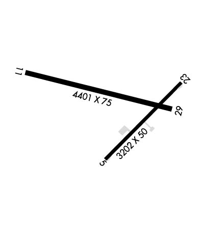
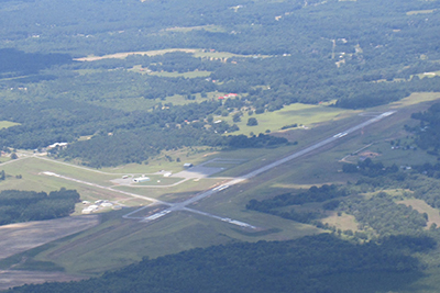
Cochran Municipal Airport offers a 4,400-runway with 24-hour fuel availability, hangars and aircraft tiedowns, passenger terminal and lounge, courtesy transportation, and is capable of handling general aviation and small corporate jets.
Ph: 478-934-2137
-
Freq: 122.8WebsiteE-Mail
                          
Service
Jet
100LL
SAF
MoGas
Fuel Avail: 24/7 Self Serv.
Full        Last Update: 03/22/2024 07:23

Self  5.25    
Misc. Info: Address: 829 GA HWY 126,   COCHRAN, GA 31014

If you are an FBO, call 1-203-262-1700 to update your info or email: FltPlan.Advertising@garmin.com
Advertise your FBO on FltPlan.com

Runway & Approach Info for K48A
Rwy
Length
Land Dist**
Approach*
  Rwy
Length
Land Dist**
Approach*
05
3202x50  3202'          
 
  
23
  3202x50  3062'          
 
11
4400x75  4400'          
 
  
29
  4400x75  4400'          
 
 * only ILS, LOC, LDA, and SDF approaches to a specific runway are shown
** For any Declared Landing Distance Available, please see A/FD or Approach plates
Runway Weight Capability (lbs.) Help
Runway IDSingle WheelDouble WheelDouble Tandem WheelDual Double Wheel
05/2325,000N/AN/AN/A
11/29N/AN/AN/AN/A
These numbers are Advisory and are not limits.   The Airport Manager should have more accurate Weight Limits
Approach Charts
Approaches    
Current Weather/Notams
Customs Information Send updates to Support@FltPlan.com
Customs Not Available
Database effective 04/18/2024
Airport Diagram of K48A
Airport Diagram might not be current.

Facility Name: COCHRAN
City Name: COCHRAN
County: BLECKLEY
State abbrev: GA
State Name: GEORGIA
   
Ownership: PUBLICLY OWNED
Use: OPEN TO THE PUBLIC
Owner's Name: CITY OF COCHRAN
Address: CITY HALL, PO BOX 8
 COCHRAN, GA 31014
Owner's Phone: 478-934-6346
  
Manager's Name: JIM WASHBURN
Address: 829 GA HWY 126
 COCHRAN, GA 31014
Phone: 478-291-6582; ALT PHONE 478-230-7843
   
FAA Region: SOUTHERN
FAA Field Office: ATL


Sunrise / Sunset times for COCHRAN

DateSunriseSunset
04/18/24 Thursday7:0020:06
04/19/24 Friday6:5820:06
04/20/24 Saturday6:5720:07
04/21/24 Sunday6:5620:08
04/22/24 Monday6:5520:08
04/23/24 Tuesday6:5420:09
04/24/24 Wednesday6:5320:10
04/25/24 Thursday6:5220:11
04/26/24 Friday6:5120:11
04/27/24 Saturday6:5020:12
04/28/24 Sunday6:4920:13
04/29/24 Monday6:4820:13
04/30/24 Tuesday6:4720:14
05/01/24 Wednesday6:4620:15

Airport Facilities

Airport Attendance ScheduleMON-SAT 0800-1200
Airport Status OPERATIONAL (This Status can change at any time - please check NOTAMS)
Airport Lighting ScheduleMIRL RWY 11/29 PRESET LOW DAWN-0800, DUSK-2100; TO ACTVT OR INCRS INTST - CTAF.
Airport Storage AvailableTie Downs
Extra Services AvailableCrop Dusting
Wind IndicatorYES - (lighted)
Control TowerNO
CTAF Frequency122.800
Unicom Frequency122.800
Rotating Beacon ColorWG
Segmented CircleYES
Landing FeeNO

Airport Inspection Data

Airport InspectedSTATE - performed by STATE AERONAUTICAL PERSONNEL
Inspection Date05/18/2023

Airport Services

Type of Fuel AvailableGrade 100LL; -1024HR FUEL SELF SERV W/MAJOR CREDIT CARD.
Airframe Repair ServiceMINOR
Power Plant Repair ServiceMINOR

Geographic Data

LatitudeN3224.0
LongitudeW08316.7 (ESTIMATED)
Arpt Elevation377ft (SURVEYED)
Magnetic Variation03W
4 miles Eof COCHRAN
Traffic Pattern Altitude
Sectional ChartATLANTA

Aircraft Data

Operations (Reported)YearlyAvg. Daily
General Aviation Transient 21006
General Aviation Local 1150032
Air Taxi 00
Commerical 00
Commuter 00
Military 4001
Aircraft based on Field
General Aviation Singles 16
General Aviation Multi 4
Jet Aircraft 0
General Aviation Helicopters 0
Military Aircraft 0
Gliders 0
Ultralights 0

FAA Services

FSS on field NO
FSS tie-in MACON
FSS Phone 1-800-WX-BRIEF
Who issues Notams MCN
Notam D service at airport YES
ARTCC Name ATLANTA

Federal Status

Airport Certification
Aircraft Rescue & Firefighting IndexNone
Airport of EntryNo
Custom Landing RightsNo
Joint Civil/MilitaryNo
Military Landing rightsYES

Federal Agreements

NATIONAL PLAN OF INTEGRATED AIRPORT SYSTEMS (NPIAS)
ASSURANCES PURSUANT TO TITLE VI, CIVIL RIGHTS ACT OF 1964
GRANT AGREEMENT HAS EXPIRED; HOWEVER, AGREEMENT REMAINS IN EFFECT FOR THIS FACILITY AS LONG AS IT IS PUBLIC USE.

Remarks

NON STD TURNAROUNDS, INADEQUATE SEPARATION RUNWAY 05/23.
FOR CD CTC ATLANTA APCH AT 678-364-6132, WHEN APCH CLSD CTC ATLANTA ARTCC AT 770-210-7692.
RWY 05/2 3 RWY 5/23 IS DAYLIGHT USE ONLY.
RWY 05/2 3 RWY 05/23 PAVEMENT IN POOR COND.
Airport Communications & Frequencies:
CTAF Frequency:
122.800
Unicom Frequency:
122.800
Remarks
  • ATLANTA LARGE TRACON PROVIDES APCH/DEP SVC 0615-2300 ON FREQ 124.2/279.6; ATLANTA ARTCC PROVIDES APCH/DEP SVC 2300-0615 ON FREQS 134.5/360.75 (MACON RCAG).
  • ATLANTA Primary Approach Frequencies:  
    124.2
    279.6
    388.2 7000 FT & ABV
    ATLANTA Primary Departure Frequencies:  
    124.2
    279.6
    388.2 7000 FT & ABV
    Runway Identifications
    Runway Identification: 05/23
    Length: 3202 ft
    Width: 50 ft
    Surface: ASPHALT-POOR CONDITION
    Edge lights:

    Treatment: NONE

     Runway: 05   Runway: 23
    Mag heading: 49°Mag heading: 229°
    Rwy Slope: .26% UpRwy Slope: -.26% Down
    Approach: Approach:
    Pattern: Left TrafficPattern: Left Traffic
    Markings: NONPRECISION INSTRUMENTMarkings: NONPRECISION INSTRUMENT
    Marking Condition: GOODMarking Condition: GOOD
    Arresting Dev: Arresting Dev:
    Lat & Long: N3223.8  W08316.8Lat. & Long.: N3224.1  W08316.3
    Elev: 324.2 ft. MSLElev: 332.5 ft. MSL
    TCH: TCH:
    Visual Glide Path: Visual Glide Path:
    Displaced Threshold: NoDisplaced Threshold: 140 feet
    Touchdown Zone: YESTouchdown Zone: YES
    Touchdown Elev.: 336.4 feetTouchdown Elev.: 336.4 feet
    Visual Glide Slope: Visual Glide Slope:
    RVR Equipment: RVR Equipment:
    RVV Equipment: NORVV Equipment: NO
    Approach Lights: Approach Lights:
    REIL: NOREIL: NO
    Centerline Lights: NOCenterline Lights: NO
    Touchdown lights: NOTouchdown lights: NO
    Runway Category: Runway with a Visual ApproachRunway Category: Runway with a Visual Approach
    Declared Distances: Declared Distances: TORA:3202' TODA:3202' ASDA:3202' LDA:3062'
    Obstructions: TREESObstructions: TREES
    Marked: NOT Marked/LightedMarked: NOT Marked/Lighted
    Clearance slope: 11:1Clearance slope: 23:1
    Obstruction height: 44 feet AGLObstruction height: 40 feet AGL
    Dist. from runway: 720 feetDist. from runway: 1143 feet
    Centerline offset: 88 right of centerlineCenterline offset: 27 feet left of centerline
    Comments: Comments:
    Runway Identification: 11/29
    Length: 4400 ft
    Width: 75 ft
    Surface: ASPHALT-GOOD CONDITION
    Edge lights: Medium Intensity

    Treatment: NONE

     Runway: 11   Runway: 29
    Mag heading: 107°Mag heading: 287°
    Rwy Slope: -1.00% DownRwy Slope: 1.00% Up
    Approach: Approach:
    Pattern: Left TrafficPattern: Left Traffic
    Markings: NONPRECISION INSTRUMENTMarkings: NONPRECISION INSTRUMENT
    Marking Condition: GOODMarking Condition: GOOD
    Arresting Dev: Arresting Dev:
    Lat & Long: N3224.2  W08317.2Lat. & Long.: N3224.0  W08316.4
    Elev: 377.4 ft. MSLElev: 333.6 ft. MSL
    TCH: 45 ft. AGLTCH: 40 ft. AGL
    Visual Glide Path: 3.25 degreesVisual Glide Path: 3.00 degrees
    Displaced Threshold: NoDisplaced Threshold: No
    Touchdown Zone: YESTouchdown Zone: YES
    Touchdown Elev.: 377.4 feetTouchdown Elev.: 357.7 feet
    Visual Glide Slope: 2-Light PAPI on LEFT side of RunwayVisual Glide Slope: 2-Light PAPI on LEFT side of Runway
    RVR Equipment: RVR Equipment:
    RVV Equipment: NORVV Equipment: NO
    Approach Lights: Approach Lights:
    REIL: NOREIL: NO
    Centerline Lights: NOCenterline Lights: NO
    Touchdown lights: NOTouchdown lights: NO
    Runway Category: Runway with a Non-precision Approach having visibility minimums greater than 3/4 mileRunway Category: Runway with a Non-precision Approach having visibility minimums greater than 3/4 mile
    Declared Distances: Declared Distances:
    Obstructions: TREESObstructions: TREES
    Marked: NOT Marked/LightedMarked: NOT Marked/Lighted
    Clearance slope: 17:1Clearance slope: 31:1
    Obstruction height: 67 feet AGLObstruction height: 68 feet AGL
    Dist. from runway: 1359 feetDist. from runway: 2363 feet
    Centerline offset: 405 left of centerlineCenterline offset: 415 feet left of centerline
    Comments: Comments:
    C:2/P: