Current Weather/Notams (Metars, TAFs, Notams, NWS Forecast, PIREPS, and nearby weather)
Customs Information Send updates to Support@FltPlan.com
Customs Not Available
Database effective 05/16/2024
Airport Diagram might not be current.
|
| Facility Name: | CURTIS MUNI |
| City Name: | CURTIS |
| County: | FRONTIER |
| State abbrev: | NE |
| State Name: | NEBRASKA |
| | |
| Ownership: | PUBLICLY OWNED |
| Use: | OPEN TO THE PUBLIC |
| Owner's Name: | CURTIS AIRPORT AUTHORITY; RYAN PATE, CHAIRMAN OF AIRPORT AUTHORITY. |
| Address: | PO BOX 11 |
| | CURTIS, NE 69025-0011 |
| Owner's Phone: | (308) 362-7088 |
| | |
| Manager's Name: | TOM BROWN |
| Address: | PO BOX 131 |
| | CURTIS, NE 69025-0131 |
| Phone: | (308) 367-7352 |
| | |
| FAA Region: | CENTRAL |
| FAA Field Office: | NONE |
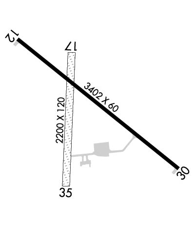
Runway Identifications
Runway Identification: 12/30Length: 3402 ft
Width: 60 ft
Surface: CONCRETE-GOOD CONDITION
Edge lights: Medium IntensityTreatment: NONE
| | Runway: 12 | | Runway: 30 |
| Mag heading: | 123° | Mag heading: | 303° |
| Rwy Slope: | -.48% Down | Rwy Slope: | .48% Up |
| Approach: | | Approach: | |
| Pattern: | Left Traffic | Pattern: | Left Traffic |
| Markings: | NONPRECISION INSTRUMENT | Markings: | NONPRECISION INSTRUMENT |
| Marking Condition: | GOOD | Marking Condition: | GOOD |
| Arresting Dev: | | Arresting Dev: | |
| Lat & Long: | N4038.5 W10028.7 | Lat. & Long.: | N4038.2 W10028.1 |
| Elev: | 2677.2 ft. MSL | Elev: | 2661.0 ft. MSL |
| TCH: | | TCH: | |
| Visual Glide Path: | | Visual Glide Path: | |
| Displaced Threshold: | No | Displaced Threshold: | No |
| Touchdown Zone: | YES | Touchdown Zone: | YES |
| Touchdown Elev.: | 2677.4 feet | Touchdown Elev.: | 2676.7 feet |
| Visual Glide Slope: | | Visual Glide Slope: | |
| RVR Equipment: | | RVR Equipment: | |
| RVV Equipment: | NO | RVV Equipment: | NO |
| Approach Lights: | | Approach Lights: | |
| REIL: | NO | REIL: | NO |
| Centerline Lights: | NO | Centerline Lights: | NO |
| Touchdown lights: | NO | Touchdown lights: | NO |
| Runway Category: | Runway with a Non-precision Approach | Runway Category: | Runway with a Non-precision Approach |
| Declared Distances: | | Declared Distances: | |
| Obstructions: | | Obstructions: | TREE |
| Marked: | | Marked: | NOT Marked/Lighted |
| Clearance slope: | 50:1 | Clearance slope: | 26:1 |
| Obstruction height: | | Obstruction height: | 12 feet AGL |
| Dist. from runway: | | Dist. from runway: | 522 feet |
| Centerline offset: | | Centerline offset: | 148 feet left of centerline |
| Comments: | CROPS 5 FT TALL ON BOTH SIDES OF THE RWY, 125 FT L & R AND GOING OUT TO 250 FT L & R FM RWY END. | Comments: | CROPS 5 FT TALL AT THE END OF RWY, 125 FT L AND EXTDG TO 250 FT L. |
Runway Identification: 17/35Length: 2200 ft
Width: 120 ft
Surface: GRASS-FAIR CONDITION
Edge lights: Treatment: NONE
| | Runway: 17 | | Runway: 35 |
| Mag heading: | 176° | Mag heading: | 356° |
| Rwy Slope: | -.35% Down | Rwy Slope: | .35% Up |
| Approach: | | Approach: | |
| Pattern: | Left Traffic | Pattern: | Left Traffic |
| Markings: | | Markings: | |
| Marking Condition: | | Marking Condition: | |
| Arresting Dev: | | Arresting Dev: | |
| Lat & Long: | N4038.5 W10028.5 | Lat. & Long.: | N4038.1 W10028.5 |
| Elev: | 2675.6 ft. MSL | Elev: | 2667.9 ft. MSL |
| TCH: | | TCH: | |
| Visual Glide Path: | | Visual Glide Path: | |
| Displaced Threshold: | No | Displaced Threshold: | No |
| Touchdown Zone: | YES | Touchdown Zone: | YES |
| Touchdown Elev.: | 2675.6 feet | Touchdown Elev.: | 2675.6 feet |
| Visual Glide Slope: | | Visual Glide Slope: | |
| RVR Equipment: | | RVR Equipment: | |
| RVV Equipment: | NO | RVV Equipment: | NO |
| Approach Lights: | | Approach Lights: | |
| REIL: | NO | REIL: | NO |
| Centerline Lights: | NO | Centerline Lights: | NO |
| Touchdown lights: | NO | Touchdown lights: | NO |
| Runway Category: | Runway with a Visual Approach | Runway Category: | Runway with a Visual Approach |
| Declared Distances: | | Declared Distances: | |
| Obstructions: | FENCE; OBSTRUCTION MAY BE CROPS DURING GROWING SEASON. | Obstructions: | PLINE |
| Marked: | MARKED | Marked: | NOT Marked/Lighted |
| Clearance slope: | 25:1 | Clearance slope: | 32:1 |
| Obstruction height: | 4 feet AGL | Obstruction height: | 15 feet AGL |
| Dist. from runway: | 102 feet | Dist. from runway: | 491 feet |
| Centerline offset: | | Centerline offset: | |
| Comments: | | Comments: | |

