Click here for more info on on SMS!

K47K

MOUNDRIDGE MUNI
MOUNDRIDGE
KS
Time Zone: Central
Lat: N 3812.5
Long: W 09730.2
Elev: 1489
Var: -07
Longest Runway: 3405
CTAF: 122.9

FBO & Flight Services info for K47K

FBOs: Update your Fuel Prices

CTY OF MOUNDRIDGEPh: 620-345-8800 Fax: 785-783-5031 Freq: 122.9
Service
Jet
100LL
SAF
MoGas
Fuel Avail: UL 91
Full        Last Update: 05/06/2024 10:18

Self  5.79  4.15
 Address: 225 S CHRISTIAN   MOUNDRIDGE, KS 67107
If you are an FBO, call 1-203-262-1700 to update your info or email: FltPlan.Advertising@garmin.com
Advertise your FBO on FltPlan.com

Runway & Approach Info for K47K
Rwy
Length
Land Dist**
Approach*
  Rwy
Length
Land Dist**
Approach*
17
3405x50  3405'          
 
  
35
  3405x50  3405'          
 
 * only ILS, LOC, LDA, and SDF approaches to a specific runway are shown
** For any Declared Landing Distance Available, please see A/FD or Approach plates
Runway Weight Capability (lbs.) Help
Runway IDSingle WheelDouble WheelDouble Tandem WheelDual Double Wheel
17/35N/AN/AN/AN/A
These numbers are Advisory and are not limits.   The Airport Manager should have more accurate Weight Limits
Approach Charts
Approaches    
Current Weather/Notams
Customs Information Send updates to Support@FltPlan.com
Customs Not Available
Database effective 05/16/2024
Airport Diagram of K47K
Airport Diagram might not be current.
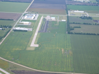
Facility Name: MOUNDRIDGE MUNI
City Name: MOUNDRIDGE
County: MC PHERSON
State abbrev: KS
State Name: KANSAS
   
Ownership: PUBLICLY OWNED
Use: OPEN TO THE PUBLIC
Owner's Name: CITY OF MOUNDRIDGE
Address: 225 SOUTH CHRISTIAN AVENUE
 MOUNDRIDGE, KS 67107
Owner's Phone: 620-345-2661
  
Manager's Name: MIKE STRAUSZ
Address: 225 SOUTH CHRISTIAN AVENUE
 MOUNDRIDGE, KS 67107
Phone: 620-386-4346; RANDY FRAZER 620-747-0525
   
FAA Region: CENTRAL
FAA Field Office: NONE


Sunrise / Sunset times for MOUNDRIDGE MUNI

DateSunriseSunset
05/06/24 Monday6:2720:27
05/07/24 Tuesday6:2620:28
05/08/24 Wednesday6:2520:28
05/09/24 Thursday6:2420:29
05/10/24 Friday6:2320:30
05/11/24 Saturday6:2220:31
05/12/24 Sunday6:2120:32
05/13/24 Monday6:2020:33
05/14/24 Tuesday6:1920:34
05/15/24 Wednesday6:1820:35
05/16/24 Thursday6:1820:36
05/17/24 Friday6:1720:36
05/18/24 Saturday6:1620:37
05/19/24 Sunday6:1520:38

Airport Facilities

Airport Attendance ScheduleMON - FRI 0800-1700
Airport Status OPERATIONAL (This Status can change at any time - please check NOTAMS)
Airport Lighting Schedule
Airport Storage AvailableTie Downs, Hanger
Extra Services AvailableAircraft Sales
Wind IndicatorYES - (unlit)
Control TowerNO
CTAF Frequency122.900
Unicom Frequency
Rotating Beacon ColorWG
Segmented CircleNO
Landing FeeNO

Airport Inspection Data

Airport InspectedSTATE - performed by STATE AERONAUTICAL PERSONNEL
Inspection Date10/24/2022

Airport Services

Type of Fuel AvailableGrade 100LLMOGAS; -10SELF SERVE FUEL AVBL BY CREDIT CARD.
Airframe Repair ServiceNONE
Power Plant Repair ServiceNONE

Geographic Data

LatitudeN3812.5
LongitudeW09730.2 (ESTIMATED)
Arpt Elevation1489ft (SURVEYED)
Magnetic Variation07E
1 miles Eof MOUNDRIDGE
Traffic Pattern Altitude
Sectional ChartWICHITA

Aircraft Data

Operations (Reported)YearlyAvg. Daily
General Aviation Transient 550015
General Aviation Local 400011
Air Taxi 00
Commerical 00
Commuter 00
Military 1000
Aircraft based on Field
General Aviation Singles 14
General Aviation Multi 0
Jet Aircraft 0
General Aviation Helicopters 0
Military Aircraft 0
Gliders 0
Ultralights 0

FAA Services

FSS on field NO
FSS tie-in WICHITA
FSS Phone 1-800-WX-BRIEF
Who issues Notams ICT
Notam D service at airport YES
ARTCC Name KANSAS CITY

Federal Status

Airport Certification
Aircraft Rescue & Firefighting IndexNone
Airport of EntryNo
Custom Landing RightsNo
Joint Civil/MilitaryNo
Military Landing rightsNo

Remarks

PHONE AVBL 24 HRS.
FOR CD CTC WICHITA APCH AT 316-350-1520.
Airport Communications & Frequencies:
CTAF Frequency:
122.900
WICHITA Primary Approach Frequencies:  
125.5
306.2
WICHITA Primary Departure Frequencies:  
125.5
306.2
Runway Identifications
Runway Identification: 17/35
Length: 3405 ft
Width: 50 ft
Surface: ASPHALT-GOOD CONDITION
Edge lights: Low Intensity

Treatment: NONE

 Runway: 17   Runway: 35
Mag heading: 173°Mag heading: 353°
Rwy Slope: -.04% DownRwy Slope: .04% Up
Approach: Approach:
Pattern: Left TrafficPattern: Left Traffic
Markings: NONPRECISION INSTRUMENTMarkings: NONPRECISION INSTRUMENT
Marking Condition: FAIRMarking Condition: FAIR
Arresting Dev: Arresting Dev:
Lat & Long: N3812.8  W09730.2Lat. & Long.: N3812.3  W09730.2
Elev: 1489.0 ft. MSLElev: 1487.8 ft. MSL
TCH: TCH:
Visual Glide Path: Visual Glide Path:
Displaced Threshold: NoDisplaced Threshold: No
Touchdown Zone: YESTouchdown Zone: YES
Touchdown Elev.: 1489.0 feetTouchdown Elev.: 1489.0 feet
Visual Glide Slope: Visual Glide Slope:
RVR Equipment: RVR Equipment:
RVV Equipment: NORVV Equipment: NO
Approach Lights: Approach Lights:
REIL: NOREIL: NO
Centerline Lights: NOCenterline Lights: NO
Touchdown lights: NOTouchdown lights: NO
Runway Category: Runway with a Non-precision ApproachRunway Category: Runway with a Non-precision Approach
Declared Distances: Declared Distances:
Obstructions: BLDGObstructions:
Marked: NOT Marked/LightedMarked:
Clearance slope: 5:1Clearance slope: 20:1
Obstruction height: 25 feet AGLObstruction height:
Dist. from runway: 325 feetDist. from runway:
Centerline offset: 782 left of centerlineCenterline offset:
Comments: Comments:
C:1/P: