
| ||||||||||||||||||||||||||||||||||||||||||||
| ||||||||||||||||||||||||||||||||||||||||||||
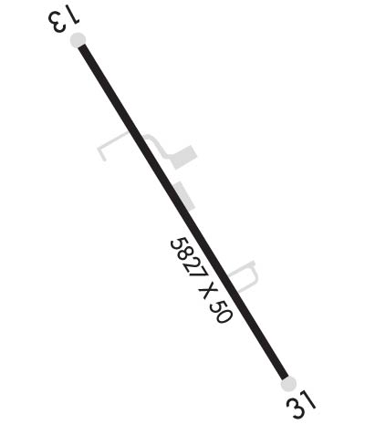
| Rwy | Rwy | |||||||
| 5827x70 | 5827' | 5827x70 | 5361' | |||||
| Runway ID | Single Wheel | Double Wheel | Double Tandem Wheel | Dual Double Wheel |
| 13/31 | 50,000 | N/A | N/A | N/A |
| These numbers are Advisory and are not limits. The Airport Manager should have more accurate Weight Limits | ||||
| FltPlan does not have IFR approach charts available for K46U. |
 Airport Diagram might not be current. | |
| Facility Name: | ALPINE |
| City Name: | ALPINE |
| County: | LINCOLN |
| State abbrev: | WY |
| State Name: | WYOMING |
| Ownership: | PRIVATELY OWNED |
| Use: | OPEN TO THE PUBLIC |
| Owner's Name: | ALPINE AIRPARK, LLC |
| Address: | 592 AIRPORT DRIVE, UNIT 3 |
| ALPINE, WY 83128 | |
| Owner's Phone: | 307-654-4646 |
| Manager's Name: | LYNN FERGUSON |
| Address: | PO BOX 3386 |
| ALPINE, WY 83128 | |
| Phone: | 307-654-4646 |
| FAA Region: | NORTHWEST MOUNTAIN |
| FAA Field Office: | DEN |
| Date | Sunrise | Sunset |
|---|---|---|
| 04/18/24 Thursday | 6:36 | 20:11 |
| 04/19/24 Friday | 6:34 | 20:13 |
| 04/20/24 Saturday | 6:33 | 20:14 |
| 04/21/24 Sunday | 6:31 | 20:15 |
| 04/22/24 Monday | 6:30 | 20:16 |
| 04/23/24 Tuesday | 6:28 | 20:17 |
| 04/24/24 Wednesday | 6:27 | 20:18 |
| 04/25/24 Thursday | 6:25 | 20:20 |
| 04/26/24 Friday | 6:24 | 20:21 |
| 04/27/24 Saturday | 6:22 | 20:22 |
| 04/28/24 Sunday | 6:21 | 20:23 |
| 04/29/24 Monday | 6:19 | 20:24 |
| 04/30/24 Tuesday | 6:18 | 20:25 |
| 05/01/24 Wednesday | 6:16 | 20:27 |
| Airport Attendance Schedule | UNATTENDED |
| Airport Status | OPERATIONAL (This Status can change at any time - please check NOTAMS) |
| Airport Lighting Schedule | ACTVT PAPI RWY 13; MIRL RWY 13/31 - CTAF |
| Airport Storage Available | Tie Downs |
| Extra Services Available | NONE |
| Wind Indicator | YES - (unlit) |
| Control Tower | NO |
| CTAF Frequency | 122.900 |
| Unicom Frequency | |
| Rotating Beacon Color | |
| Segmented Circle | NO |
| Landing Fee | YES; FEES IMPOSED FOR LDG OVNGT OR EXTDD STAY PRKG. RAMP & PRKG SPACE VERY LTD SPCLY IN THE WINTER. |
| Airport Inspected | STATE - performed by STATE AERONAUTICAL PERSONNEL |
| Inspection Date | 09/19/2022 |
| Type of Fuel Available | Grade 100LL, JET A (freeze point -40C); -A 24 HR SELF SVC FUEL AVBL WITH CREDIT CARD; FULL SVC JET A & AVGAS ALSO AVBL ARNGD IN ADVN PHONE 307-654-4646. |
| Airframe Repair Service | NONE |
| Power Plant Repair Service | NONE |
| Latitude | N4310.9 |
| Longitude | W11102.3 (ESTIMATED) |
| Arpt Elevation | 5637ft (SURVEYED) |
| Magnetic Variation | 11E |
| 1 miles NW | of ALPINE |
| Traffic Pattern Altitude | |
| Sectional Chart | SALT LAKE CITY |
| Operations (Reported) | Yearly | Avg. Daily |
|---|---|---|
| General Aviation Transient | 1350 | 4 |
| General Aviation Local | 1680 | 5 |
| Air Taxi | 0 | 0 |
| Commerical | 0 | 0 |
| Commuter | 0 | 0 |
| Military | 0 | 0 |
| Aircraft based on Field | |
|---|---|
| General Aviation Singles | 67 |
| General Aviation Multi | 6 |
| Jet Aircraft | 24 |
| General Aviation Helicopters | 12 |
| Military Aircraft | 0 |
| Gliders | 0 |
| Ultralights | 0 |
| FSS on field | NO |
| FSS tie-in | CASPER |
| FSS Phone | 1-800-WX-BRIEF |
| Who issues Notams | CPR |
| Notam D service at airport | YES |
| ARTCC Name | SALT LAKE CITY |
| Airport Certification | |
| Aircraft Rescue & Firefighting Index | None |
| Airport of Entry | No |
| Custom Landing Rights | No |
| Joint Civil/Military | No |
| Military Landing rights | No |
| ARPT CLSD NGTS |
| AVOID LOW LEVEL FLT OVER CITY OR EAST OF RWY, |
| NOISE SENS ARPT WX PMTG LND RWY 13 TKOF RWY 31 FOR NOISE ABATEMENT; DUE TO THE PROXIMITY OF THE TOWN OF ALPINE & ARPT HOUSING; TOUCH & GOES ARE PROHIBITED. |
| RESIDENTIAL TWYS ESTAB THEIR OWN WT LMTS & RQR APVL PRIOR TO USE. |
| FOR CD CTC SALT LAKE ARTCC AT 801-320-2568. |
| TSNT TFC MUST CTC THE AMGR FOR INFO ON UNIQUE LCL FLYING OPNS BFR USING THE ARPT. |
| VOLUNTARY CURFEW DUSK TO DAWN. NGT LDGS LMTD TO AIRPARK RESIDENTS ONLY. NGT TIME LDGS AND TKFS NOT ADVS TO PILOTS UNFAMILIAR WITH TRRN. WILDLIFE ON AND INVOF OF ARPT. BIRD/WATERFOWL HAZ. |
| FOR RWY COND IN WINTER CTC - AMGR. |
| VRB RWY COND AND BA WINTER MOS. SNBNK ALG RWY & TWY EDGES POSS FALL, WINT, SPRING MOS. TREACHEROUS MTN TERR IN CLOSE PROXIMITY ALL QUADS OF RWY. |
| RWY 31 RWY 13/31 FENCES, BLDGS & TREES WI 150 FT N & S OF CNTRLN. |
| Runway: 13 | Runway: 31 | ||
| Mag heading: | 131° | Mag heading: | 311° |
| Rwy Slope: | .21% Up | Rwy Slope: | -.21% Down |
| Approach: | Approach: | ||
| Pattern: | Right Traffic | Pattern: | Left Traffic |
| Markings: | NONPRECISION INSTRUMENT | Markings: | NONPRECISION INSTRUMENT |
| Marking Condition: | GOOD | Marking Condition: | GOOD |
| Arresting Dev: | Arresting Dev: | ||
| Lat & Long: | N4311.3 W11102.7 | Lat. & Long.: | N4310.5 W11101.9 |
| Elev: | 5624.4 ft. MSL | Elev: | 5636.9 ft. MSL |
| TCH: | 22 ft. AGL | TCH: | |
| Visual Glide Path: | 3.00 degrees | Visual Glide Path: | |
| Displaced Threshold: | No | Displaced Threshold: | 466 feet |
| Touchdown Zone: | YES | Touchdown Zone: | YES |
| Touchdown Elev.: | 5632.0 feet | Touchdown Elev.: | 5636.2 feet |
| Visual Glide Slope: | 2-Light PAPI on LEFT side of Runway | Visual Glide Slope: | |
| RVR Equipment: | RVR Equipment: | ||
| RVV Equipment: | NO | RVV Equipment: | NO |
| Approach Lights: | Approach Lights: | ||
| REIL: | NO | REIL: | NO |
| Centerline Lights: | NO | Centerline Lights: | NO |
| Touchdown lights: | NO | Touchdown lights: | NO |
| Runway Category: | Runway with a Visual Approach | Runway Category: | Runway with a Visual Approach |
| Declared Distances: | Declared Distances: | ||
| Obstructions: | Obstructions: | ROAD | |
| Marked: | Marked: | NOT Marked/Lighted | |
| Clearance slope: | 20:1 | Clearance slope: | 1:1; RWY 31 FM DSPLCD THLD 20:1 TO 45 FT TREE 480 FT EOR 75 FT L. |
| Obstruction height: | Obstruction height: | 19 feet AGL | |
| Dist. from runway: | Dist. from runway: | 200 feet | |
| Centerline offset: | Centerline offset: | ||
| Comments: | Comments: | 16 FT PAVED ROAD 106 FT FM RWY END CROSSES RWY END. |