Approach Charts
| FltPlan does not have IFR approach charts available for K45G. |
Current Weather/Notams (Metars, TAFs, Notams, NWS Forecast, PIREPS, and nearby weather)
Customs Information Send updates to Support@FltPlan.com
Customs Not Available
Database effective 05/16/2024
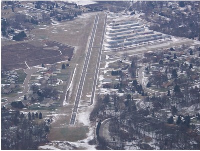
| Facility Name: | BRIGHTON |
| City Name: | BRIGHTON |
| County: | LIVINGSTON |
| State abbrev: | MI |
| State Name: | MICHIGAN |
| | |
| Ownership: | PRIVATELY OWNED |
| Use: | OPEN TO THE PUBLIC |
| Owner's Name: | BRIGHTON ARPT ASSOCIATION |
| Address: | 8664 HYNE RD |
| | BRIGHTON, MI 48114-8925 |
| Owner's Phone: | 810-223-6819 |
| | |
| Manager's Name: | CLINTON RAY |
| Address: | 8664 HYNE RD |
| | BRIGHTON, MI 48114-8925 |
| Phone: | 810-223-6819 |
| | |
| FAA Region: | GREAT LAKES |
| FAA Field Office: | DET |
Runway Identifications
Runway Identification: 04/22Length: 3105 ft
Width: 24 ft
Surface: ASPHALT-GOOD CONDITION
Edge lights: Treatment: NONE
| | Runway: 04 | | Runway: 22 |
| Mag heading: | 41° | Mag heading: | 221° |
| Rwy Slope: | .13% Up | Rwy Slope: | -.13% Down |
| Approach: | | Approach: | |
| Pattern: | Left Traffic | Pattern: | Left Traffic |
| Markings: | BASIC | Markings: | BASIC |
| Marking Condition: | GOOD | Marking Condition: | GOOD |
| Arresting Dev: | | Arresting Dev: | |
| Lat & Long: | N4234.0 W08346.9 | Lat. & Long.: | N4234.4 W08346.5 |
| Elev: | 969.0 ft. MSL | Elev: | 973.0 ft. MSL |
| TCH: | | TCH: | |
| Visual Glide Path: | | Visual Glide Path: | |
| Displaced Threshold: | 195 feet | Displaced Threshold: | 365 feet |
| Touchdown Zone: | NO | Touchdown Zone: | NO |
| Touchdown Elev.: | | Touchdown Elev.: | |
| Visual Glide Slope: | | Visual Glide Slope: | |
| RVR Equipment: | | RVR Equipment: | |
| RVV Equipment: | NO | RVV Equipment: | NO |
| Approach Lights: | | Approach Lights: | |
| REIL: | NO | REIL: | NO |
| Centerline Lights: | NO | Centerline Lights: | NO |
| Touchdown lights: | NO | Touchdown lights: | NO |
| Runway Category: | Runway with a Visual Approach | Runway Category: | Runway with a Visual Approach |
| Declared Distances: | | Declared Distances: | |
| Obstructions: | TREES | Obstructions: | TREES |
| Marked: | NOT Marked/Lighted | Marked: | NOT Marked/Lighted |
| Clearance slope: | 3:1; APCH RATIO 1:1 TO DTHR OVR +9 FT TREES, 47 FT DIST, 100 FT L. | Clearance slope: | CTLG OBSTN EXCEEDS A 45 DEG SLP. APCH RATIO 18:1 TO DTHR OVR +59 FT TREES, 1065 FT DIST, 0 FT B. |
| Obstruction height: | 80 feet AGL | Obstruction height: | 72 feet AGL |
| Dist. from runway: | 471 feet | Dist. from runway: | 247 feet |
| Centerline offset: | 125 right of centerline | Centerline offset: | 125 feet right of centerline |
| Comments: | | Comments: | PVT ROAD, 100 FT DIST; +9 FT PUB ROAD, 150 FT DIST. |