Current Weather/Notams (Metars, TAFs, Notams, NWS Forecast, PIREPS, and nearby weather)
Customs Information Send updates to Support@FltPlan.com
Customs Not Available
Database effective 05/16/2024
Airport Diagram might not be current.
|
| Facility Name: | SKY ACRES |
| City Name: | MILLBROOK |
| County: | DUTCHESS |
| State abbrev: | NY |
| State Name: | NEW YORK |
| | |
| Ownership: | PRIVATELY OWNED |
| Use: | OPEN TO THE PUBLIC |
| Owner's Name: | SKY ACRES ENTERPRISES INC |
| Address: | 30 AIRWAY DRIVE |
| | LAGRANGEVILLE, NY 12540 |
| Owner's Phone: | 845-677-5010 |
| | |
| Manager's Name: | STEVEN STYLES |
| Address: | 30 AIRWAY DRIVE |
| | LAGRANGEVILLE, NY 12540 |
| Phone: | 845-677-5010 |
| | |
| FAA Region: | EASTERN |
| FAA Field Office: | NYC |
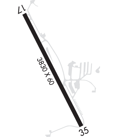
Runway Identifications
Runway Identification: 17/35Length: 3828 ft
Width: 60 ft
Surface: ASPHALT-GOOD CONDITION
Edge lights: Medium IntensityTreatment: NONE
| | Runway: 17 | | Runway: 35 |
| Mag heading: | 167° | Mag heading: | 347° |
| Rwy Slope: | 1.33% Up | Rwy Slope: | -1.33% Down |
| Approach: | | Approach: | |
| Pattern: | Left Traffic | Pattern: | Left Traffic |
| Markings: | NONPRECISION INSTRUMENT | Markings: | NONPRECISION INSTRUMENT |
| Marking Condition: | GOOD | Marking Condition: | GOOD |
| Arresting Dev: | | Arresting Dev: | |
| Lat & Long: | N4142.7 W07344.5 | Lat. & Long.: | N4142.2 W07344.1 |
| Elev: | 646.1 ft. MSL | Elev: | 697.0 ft. MSL |
| TCH: | | TCH: | 33 ft. AGL |
| Visual Glide Path: | | Visual Glide Path: | 3.00 degrees |
| Displaced Threshold: | No | Displaced Threshold: | No |
| Touchdown Zone: | YES | Touchdown Zone: | YES |
| Touchdown Elev.: | 694.3 feet | Touchdown Elev.: | 697.3 feet |
| Visual Glide Slope: | | Visual Glide Slope: | 2-Light PAPI on LEFT side of Runway; PAPI RWY 35 UNUSBL 8 DEGS RIGHT OF CNTRLN. |
| RVR Equipment: | | RVR Equipment: | |
| RVV Equipment: | NO | RVV Equipment: | NO |
| Approach Lights: | | Approach Lights: | |
| REIL: | NO | REIL: | NO |
| Centerline Lights: | NO | Centerline Lights: | NO |
| Touchdown lights: | NO | Touchdown lights: | NO |
| Runway Category: | Runway with a Non-precision Approach | Runway Category: | Runway with a Non-precision Approach |
| Declared Distances: | | Declared Distances: | |
| Obstructions: | TREES | Obstructions: | TREES |
| Marked: | NOT Marked/Lighted | Marked: | NOT Marked/Lighted |
| Clearance slope: | 7:1 | Clearance slope: | 10:1 |
| Obstruction height: | 19 feet AGL | Obstruction height: | 49 feet AGL |
| Dist. from runway: | 336 feet | Dist. from runway: | 713 feet |
| Centerline offset: | 256 right of centerline | Centerline offset: | 88 feet right of centerline |
| Comments: | RWY 17 22 FT TREES 180 FT FM RWY END 159 FT LEFT. | Comments: | RWY 35 16 FT TREES 116 FT FM RWY END 125 FT RIGHT. |

