Click here for more info on on SMS!

K44C

BELOIT
BELOIT
WI
Time Zone: Central
Lat: N 4229.9
Long: W 08858.1
Elev: 817
Var: +03
Longest Runway: 3300
CTAF: 122.7

FBO & Flight Services info for K44C

FBOs: Update your Fuel Prices

BELOIT ARPTPh: 773-914-9938
-
Freq: 122.7
Service
Jet
100LL
SAF
MoGas
Fuel Avail: ~~FUEL NOT AVAILABLE
Full        Last Update: 04/19/2024 00:01:45

Self        
 Address: 4046 STATE HWY 67 BELOIT, WI 53511
If you are an FBO, call 1-203-262-1700 to update your info or email: FltPlan.Advertising@garmin.com
Advertise your FBO on FltPlan.com

Runway & Approach Info for K44C
Rwy
Length
Land Dist**
Approach*
  Rwy
Length
Land Dist**
Approach*
07
3300x50  3300'          
 
  
25
  3300x50  2950'          
 
 * only ILS, LOC, LDA, and SDF approaches to a specific runway are shown
** For any Declared Landing Distance Available, please see A/FD or Approach plates
Runway Weight Capability (lbs.) Help
Runway IDSingle WheelDouble WheelDouble Tandem WheelDual Double Wheel
07/2512,500N/AN/AN/A
These numbers are Advisory and are not limits.   The Airport Manager should have more accurate Weight Limits
Approach Charts
Approaches    
Current Weather/Notams
Customs Information Send updates to Support@FltPlan.com
Customs Not Available
Database effective 04/18/2024
Airport Diagram of K44C
Airport Diagram might not be current.

Facility Name: BELOIT
City Name: BELOIT
County: ROCK
State abbrev: WI
State Name: WISCONSIN
   
Ownership: PRIVATELY OWNED
Use: OPEN TO THE PUBLIC
Owner's Name: STEVE STAUBER
Address: 4046 STATE HWY 67
 BELOIT, WI 53511
Owner's Phone: 773-914-9938
  
Manager's Name: STEVE STAUBER
Address: 4046 STATE HWY 67; EMAIL ADDRESS: SHSTAUBER@AOL.COM (ALL LOWER CASE)
 BELOIT, WI 53511
Phone: 773-914-9938
   
FAA Region: GREAT LAKES
FAA Field Office: CHI


Sunrise / Sunset times for BELOIT

DateSunriseSunset
04/18/24 Thursday6:0919:42
04/19/24 Friday6:0719:43
04/20/24 Saturday6:0619:44
04/21/24 Sunday6:0419:45
04/22/24 Monday6:0319:47
04/23/24 Tuesday6:0119:48
04/24/24 Wednesday6:0019:49
04/25/24 Thursday5:5819:50
04/26/24 Friday5:5719:51
04/27/24 Saturday5:5519:52
04/28/24 Sunday5:5419:53
04/29/24 Monday5:5219:54
04/30/24 Tuesday5:5119:56
05/01/24 Wednesday5:5019:57

Airport Facilities

Airport Attendance ScheduleMAY-AUG MON-FRI 1000-1400
Airport Status OPERATIONAL (This Status can change at any time - please check NOTAMS)
Airport Lighting ScheduleACTVT LIRL RY 07/25 - CTAF.
Airport Storage AvailableTie Downs, Hanger
Extra Services AvailableGlider, Parachute Jumping, Glider Towing
Wind IndicatorYES - (lighted)
Control TowerNO
CTAF Frequency122.700
Unicom Frequency122.700
Rotating Beacon ColorWG
Segmented CircleNO
Landing FeeNO

Airport Inspection Data

Airport InspectedSTATE - performed by STATE AERONAUTICAL PERSONNEL
Inspection Date06/09/2022

Airport Services

Type of Fuel AvailableGrade 100LL
Airframe Repair ServiceNONE
Power Plant Repair ServiceNONE

Geographic Data

LatitudeN4229.9
LongitudeW08858.1 (ESTIMATED)
Arpt Elevation817ft (SURVEYED)
Magnetic Variation03W
3 miles Eof BELOIT
Traffic Pattern Altitude700
Sectional ChartCHICAGO

Aircraft Data

Operations (Reported)YearlyAvg. Daily
General Aviation Transient 450012
General Aviation Local 1500041
Air Taxi 1000
Commerical 00
Commuter 00
Military 300
Aircraft based on Field
General Aviation Singles 25
General Aviation Multi 3
Jet Aircraft 0
General Aviation Helicopters 1
Military Aircraft 0
Gliders 0
Ultralights 2

FAA Services

FSS on field NO
FSS tie-in GREEN BAY
FSS Phone 1-800-WX-BRIEF
Who issues Notams GRB
Notam D service at airport YES
ARTCC Name CHICAGO

Federal Status

Airport Certification
Aircraft Rescue & Firefighting IndexNone
Airport of EntryNo
Custom Landing RightsNo
Joint Civil/MilitaryNo
Military Landing rightsNo

Remarks

GLIDER OPNS ON & INVOF ARPT.
FOR CD CTC CHICAGO ARTCC AT 630-906-8921.
(DSPLCD THR APCH RATIO, RWY 25) APCH RTIO 10:1 TO DSPLCD THLD; 54 FT SILO 560 FT FM DSPLCD THLD 190 FT R.
RWY 07/2 5 NSTD LIRL 100 FT WIDE; 50 FT LEFT & RIGHT OF RY CNTRLN.
Airport Communications & Frequencies:
CTAF Frequency:
122.700
Unicom Frequency:
122.700
ROCKFORD Primary Approach Frequencies:  
121.0
327.0
ROCKFORD Primary Departure Frequencies:  
121.0
327.0
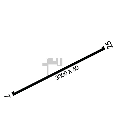
Runway Identifications
Runway Identification: 07/25
Length: 3300 ft
Width: 50 ft
Surface: ASPHALT-FAIR CONDITION
Edge lights: Non-Standard Lighting System

Treatment: NONE

 Runway: 07   Runway: 25
Mag heading: 67°Mag heading: 247°
Rwy Slope: .27% UpRwy Slope: -.27% Down
Approach: Approach:
Pattern: Left TrafficPattern: Left Traffic
Markings: NONSTANDARDMarkings: BASIC
Marking Condition: GOOD; NSTD THR MARKINGS; LCTD 92 FT FM END OF PAVEMENT.Marking Condition: GOOD
Arresting Dev: Arresting Dev:
Lat & Long: N4229.7  W08858.4Lat. & Long.: N4230.0  W08857.7
Elev: 802.0 ft. MSLElev: 811.0 ft. MSL
TCH: TCH:
Visual Glide Path: Visual Glide Path:
Displaced Threshold: NoDisplaced Threshold: 350 feet
Touchdown Zone: YESTouchdown Zone: YES
Touchdown Elev.: 817.0 feetTouchdown Elev.: 817.0 feet
Visual Glide Slope: Visual Glide Slope:
RVR Equipment: RVR Equipment:
RVV Equipment: NORVV Equipment: NO
Approach Lights: Approach Lights:
REIL: NOREIL: NO
Centerline Lights: NOCenterline Lights: NO
Touchdown lights: NOTouchdown lights: NO
Runway Category: Runway with a Visual ApproachRunway Category: Runway with a Visual Approach
Declared Distances: Declared Distances:
Obstructions: Obstructions: ROAD
Marked: Marked: NOT Marked/Lighted
Clearance slope: 20:1Clearance slope: APCH RATIO 20:1 TO DTHR.
Obstruction height: Obstruction height: 15 feet AGL
Dist. from runway: Dist. from runway: 200 feet
Centerline offset: Centerline offset: 110 feet right of centerline
Comments: Comments: 15 FT ROAD 0 - 200 FT FM RWY END; 110 FT R.
C:/P: