Click here for more info on on SMS!

K42V

JONES
BENKELMAN
NE
Time Zone: Mountain
Lat: N 4003.5
Long: W 10132.8
Elev: 3126
Var: -09
Longest Runway: 3500
CTAF: 122.9

FBO & Flight Services info for K42V

FBOs: Update your Fuel Prices

AIRPORTPh: 308-423-2941
-
Freq: 122.9
Service
Jet
100LL
SAF
MoGas
Fuel Avail: ~~100LL, JET A (freeze point -40C); FUEL FOR EMERG USE ONLY.
Full        Last Update: 04/23/2024 05:40:10

Self        
If you are an FBO, call 1-203-262-1700 to update your info or email: FltPlan.Advertising@garmin.com
Advertise your FBO on FltPlan.com

Runway & Approach Info for K42V
Rwy
Length
Land Dist**
Approach*
  Rwy
Length
Land Dist**
Approach*
15
3500x25  3500'          
 
  
33
  3500x25  2500'          
 
 * only ILS, LOC, LDA, and SDF approaches to a specific runway are shown
** For any Declared Landing Distance Available, please see A/FD or Approach plates
Runway Weight Capability (lbs.) Help
Runway IDSingle WheelDouble WheelDouble Tandem WheelDual Double Wheel
15/33N/AN/AN/AN/A
These numbers are Advisory and are not limits.   The Airport Manager should have more accurate Weight Limits
Approach Charts
FltPlan does not have IFR approach charts available for K42V.
Current Weather/Notams
Customs Information Send updates to Support@FltPlan.com
Customs Not Available
Database effective 05/16/2024
Airport Diagram of K42V
Airport Diagram might not be current.

Facility Name: JONES
City Name: BENKELMAN
County: DUNDY
State abbrev: NE
State Name: NEBRASKA
   
Ownership: PRIVATELY OWNED
Use: OPEN TO THE PUBLIC
Owner's Name: STAN JONES
Address: BOX 685
 BENKELMAN, NE 69021
Owner's Phone: 308-423-2941
  
Manager's Name: STAN JONES
Address: BOX 685
 BENKELMAN, NE 69021
Phone: 308-423-2941; ALTN NR 308-883-0047
   
FAA Region: CENTRAL
FAA Field Office: NONE


Sunrise / Sunset times for JONES

DateSunriseSunset
04/22/24 Monday5:5719:33
04/23/24 Tuesday5:5619:34
04/24/24 Wednesday5:5419:35
04/25/24 Thursday5:5319:36
04/26/24 Friday5:5219:37
04/27/24 Saturday5:5019:38
04/28/24 Sunday5:4919:39
04/29/24 Monday5:4819:40
04/30/24 Tuesday5:4619:41
05/01/24 Wednesday5:4519:42
05/02/24 Thursday5:4419:43
05/03/24 Friday5:4319:44
05/04/24 Saturday5:4119:45
05/05/24 Sunday5:4019:46

Airport Facilities

Airport Attendance Schedule7 Days A Week DALGT
Airport Status OPERATIONAL (This Status can change at any time - please check NOTAMS)
Airport Lighting Schedule
Airport Storage AvailableTie Downs
Extra Services AvailableCrop Dusting
Wind IndicatorYES - (unlit)
Control TowerNO
CTAF Frequency122.900
Unicom Frequency
Rotating Beacon Color
Segmented CircleNO
Landing FeeNO

Airport Inspection Data

Airport InspectedSTATE - performed by STATE AERONAUTICAL PERSONNEL
Inspection Date10/09/1996

Airport Services

Type of Fuel AvailableNone
Airframe Repair ServiceNONE
Power Plant Repair ServiceNONE

Geographic Data

LatitudeN4003.5
LongitudeW10132.8 (ESTIMATED)
Arpt Elevation3126ft (ESTIMATED)
Magnetic Variation09E
1 miles NWof BENKELMAN
Traffic Pattern Altitude
Sectional ChartCHEYENNE

Aircraft Data

Operations (Reported)YearlyAvg. Daily
General Aviation Transient 3001
General Aviation Local 30008
Air Taxi 00
Commerical 00
Commuter 00
Military 00
Aircraft based on Field
General Aviation Singles 5
General Aviation Multi 1
Jet Aircraft 0
General Aviation Helicopters 0
Military Aircraft 0
Gliders 0
Ultralights 0

FAA Services

FSS on field NO
FSS tie-in COLUMBUS
FSS Phone 1-800-WX-BRIEF
Who issues Notams OLU
Notam D service at airport YES
ARTCC Name DENVER

Federal Status

Airport Certification
Aircraft Rescue & Firefighting IndexNone
Airport of EntryNo
Custom Landing RightsNo
Joint Civil/MilitaryNo
Military Landing rightsNo

Remarks

NEW CROSSWIND RY UNDER CONSTRUCTION WEST OF RY 15/33.
FOR CD CTC DENVER ARTCC AT 303-651-4257.
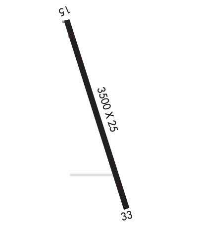
Runway Identifications
Runway Identification: 15/33
Length: 3500 ft
Width: 25 ft
Surface: CONCRETE
Edge lights:

Treatment: NONE

 Runway: 15   Runway: 33
Mag heading: N/AMag heading: N/A
Approach: Approach:
Pattern: Left TrafficPattern: Left Traffic
Markings: Markings:
Marking Condition: Marking Condition:
Arresting Dev: Arresting Dev:
Lat & Long:   Lat. & Long.:   
Elev: N/AElev: N/A
TCH: TCH:
Visual Glide Path: Visual Glide Path:
Displaced Threshold: NoDisplaced Threshold: 1000 feet
Touchdown Zone: NOTouchdown Zone: NO
Touchdown Elev.: Touchdown Elev.:
Visual Glide Slope: Visual Glide Slope:
RVR Equipment: RVR Equipment:
RVV Equipment: NORVV Equipment: NO
Approach Lights: Approach Lights:
REIL: NOREIL: NO
Centerline Lights: NOCenterline Lights: NO
Touchdown lights: NOTouchdown lights: NO
Runway Category: Runway with a Visual ApproachRunway Category: Runway with a Visual Approach
Declared Distances: Declared Distances:
Obstructions: ROADObstructions:
Marked: NOT Marked/LightedMarked:
Clearance slope: 32:1Clearance slope: 50:1
Obstruction height: 17 feet AGLObstruction height:
Dist. from runway: 550 feetDist. from runway:
Centerline offset: Centerline offset:
Comments: Comments: +16 FT ROAD 105 FT FM EOR L/R.
C:/P: