Approach Charts
| FltPlan does not have IFR approach charts available for K42U. |
Current Weather/Notams (Metars, TAFs, Notams, NWS Forecast, PIREPS, and nearby weather)
Customs Information Send updates to Support@FltPlan.com
Customs Not Available
Database effective 05/16/2024
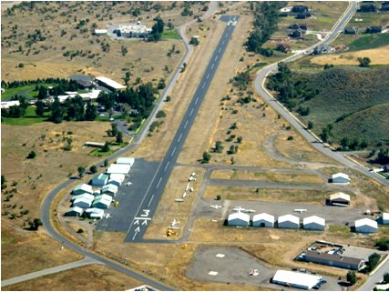
Airport Diagram might not be current.
|
| Facility Name: | MORGAN COUNTY |
| City Name: | MORGAN |
| County: | MORGAN |
| State abbrev: | UT |
| State Name: | UTAH |
| | |
| Ownership: | PUBLICLY OWNED |
| Use: | OPEN TO THE PUBLIC |
| Owner's Name: | MORGAN COUNTY |
| Address: | 48 WEST YOUNG ST., PO BOX 886 |
| | MORGAN, UT 84050 |
| Owner's Phone: | 801-845-4011; COUNTY CLERK |
| | |
| Manager's Name: | JOE GARFIELD |
| Address: | 5876 N COTTONWOOD CANYON RD, 3806 W WILLOWCREEK ROAD |
| | MT. GREEN, UT 84050 |
| Phone: | 801-821-6619 |
| | |
| FAA Region: | NORTHWEST MOUNTAIN |
| FAA Field Office: | DEN |
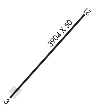
Runway Identifications
Runway Identification: 03/21Length: 3904 ft
Width: 50 ft
Surface: ASPHALT-GOOD CONDITION
Edge lights: Treatment: NONE
| | Runway: 03 | | Runway: 21 |
| Mag heading: | N/A | Mag heading: | N/A |
| Rwy Slope: | 1.97% Up | Rwy Slope: | -1.97% Down |
| Approach: | | Approach: | |
| Pattern: | Left Traffic | Pattern: | Left Traffic |
| Markings: | BASIC | Markings: | BASIC |
| Marking Condition: | FAIR | Marking Condition: | FAIR |
| Arresting Dev: | | Arresting Dev: | |
| Lat & Long: | N4108.7 W11146.3 | Lat. & Long.: | N4109.1 W11145.7 |
| Elev: | 4943.0 ft. MSL | Elev: | 5020.0 ft. MSL |
| TCH: | | TCH: | |
| Visual Glide Path: | | Visual Glide Path: | |
| Displaced Threshold: | 212 feet | Displaced Threshold: | 214 feet |
| Touchdown Zone: | NO | Touchdown Zone: | NO |
| Touchdown Elev.: | | Touchdown Elev.: | |
| Visual Glide Slope: | | Visual Glide Slope: | |
| RVR Equipment: | | RVR Equipment: | |
| RVV Equipment: | NO | RVV Equipment: | NO |
| Approach Lights: | | Approach Lights: | |
| REIL: | NO | REIL: | NO |
| Centerline Lights: | NO | Centerline Lights: | NO |
| Touchdown lights: | NO | Touchdown lights: | NO |
| Runway Category: | Runway with a Visual Approach | Runway Category: | Runway with a Visual Approach |
| Declared Distances: | | Declared Distances: | |
| Obstructions: | ROAD | Obstructions: | TREES |
| Marked: | NOT Marked/Lighted | Marked: | NOT Marked/Lighted |
| Clearance slope: | APCH SLOPE 0:1 TO DSPLCD THLD OVR 12 FT HGR 0 FT DSTC, 123 FT L. | Clearance slope: | APCH SLOPE 11:1 TO DSPLCD THLD. |
| Obstruction height: | 15 feet AGL | Obstruction height: | 40 feet AGL |
| Dist. from runway: | 209 feet | Dist. from runway: | 225 feet |
| Centerline offset: | B | Centerline offset: | 75 feet left of centerline |
| Comments: | 5 FT FENCE 57-199 FT DSTC 89 FT L. | Comments: | ELECTRICAL BOX - 163 FT DSTC, 93 FT R. |