Current Weather/Notams (Metars, TAFs, Notams, NWS Forecast, PIREPS, and nearby weather)
Customs Information Send updates to Support@FltPlan.com
Customs Not Available
Database effective 04/18/2024
Airport Diagram might not be current.
|
| Facility Name: | KEYSTONE HEIGHTS |
| City Name: | KEYSTONE HEIGHTS |
| County: | CLAY |
| State abbrev: | FL |
| State Name: | FLORIDA |
| | |
| Ownership: | PUBLICLY OWNED |
| Use: | OPEN TO THE PUBLIC |
| Owner's Name: | KEYSTONE HEIGHTS AIRPORT AUTHORITY; CONTACT PERSON: DAVID KIRKLAND 352-473-0031 |
| Address: | 7150 AIRPORT ROAD |
| | STARKE, FL 32091-9347 |
| Owner's Phone: | 352-473-0031 |
| | |
| Manager's Name: | CRAIG COON |
| Address: | 7150 AIRPORT RD, 7150 AIRPORT ROAD |
| | STARKE, FL 32091-9347 |
| Phone: | 352-473-0031 |
| | |
| FAA Region: | SOUTHERN |
| FAA Field Office: | ORL |
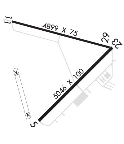
Runway Identifications
Runway Identification: 05/23Length: 5046 ft
Width: 100 ft
Surface: ASPHALT-FAIR CONDITION
Edge lights: Medium IntensityTreatment: NONE
Weight: PCN 15 /R/B/X/T
| | Runway: 05 | | Runway: 23 |
| Mag heading: | 50° | Mag heading: | 230° |
| Rwy Slope: | .38% Up | Rwy Slope: | -.38% Down |
| Approach: | | Approach: | |
| Pattern: | Right Traffic | Pattern: | Left Traffic |
| Markings: | NONPRECISION INSTRUMENT | Markings: | NONPRECISION INSTRUMENT |
| Marking Condition: | FAIR | Marking Condition: | FAIR |
| Arresting Dev: | | Arresting Dev: | |
| Lat & Long: | N2950.2 W08203.1 | Lat. & Long.: | N2950.8 W08202.4 |
| Elev: | 176.5 ft. MSL | Elev: | 195.9 ft. MSL |
| TCH: | 40 ft. AGL | TCH: | 40 ft. AGL |
| Visual Glide Path: | 3.00 degrees | Visual Glide Path: | 3.00 degrees |
| Displaced Threshold: | No | Displaced Threshold: | No |
| Touchdown Zone: | YES | Touchdown Zone: | YES |
| Touchdown Elev.: | 190.0 feet | Touchdown Elev.: | 196.0 feet |
| Visual Glide Slope: | 2-Light PAPI on LEFT side of Runway | Visual Glide Slope: | 2-Light PAPI on LEFT side of Runway |
| RVR Equipment: | | RVR Equipment: | |
| RVV Equipment: | NO | RVV Equipment: | NO |
| Approach Lights: | | Approach Lights: | |
| REIL: | YES | REIL: | YES |
| Centerline Lights: | NO | Centerline Lights: | NO |
| Touchdown lights: | NO | Touchdown lights: | NO |
| Runway Category: | Runway with a Non-precision Approach having visibility minimums greater than 3/4 mile | Runway Category: | Runway with a Visual Approach |
| Declared Distances: | | Declared Distances: | |
| Obstructions: | TREES | Obstructions: | TREES |
| Marked: | NOT Marked/Lighted | Marked: | NOT Marked/Lighted |
| Clearance slope: | 34:1 | Clearance slope: | 25:1 |
| Obstruction height: | 51 feet AGL | Obstruction height: | 39 feet AGL |
| Dist. from runway: | 1960 feet | Dist. from runway: | 1175 feet |
| Centerline offset: | 30 left of centerline | Centerline offset: | 235 feet left of centerline |
| Comments: | | Comments: | |
Runway Identification: 11/29Length: 4899 ft
Width: 75 ft
Surface: ASPHALT-FAIR CONDITION
Edge lights: High IntensityTreatment: NONE
Weight: PCN 14 /R/C/X/T
| | Runway: 11 | | Runway: 29 |
| Mag heading: | 110° | Mag heading: | 290° |
| Rwy Slope: | .21% Up | Rwy Slope: | -.21% Down |
| Approach: | | Approach: | |
| Pattern: | Left Traffic | Pattern: | Right Traffic |
| Markings: | BASIC | Markings: | BASIC |
| Marking Condition: | FAIR | Marking Condition: | FAIR |
| Arresting Dev: | | Arresting Dev: | |
| Lat & Long: | N2951.0 W08203.4 | Lat. & Long.: | N2950.8 W08202.5 |
| Elev: | 185.6 ft. MSL | Elev: | 195.7 ft. MSL |
| TCH: | 40 ft. AGL | TCH: | 40 ft. AGL |
| Visual Glide Path: | 3.00 degrees | Visual Glide Path: | 3.00 degrees |
| Displaced Threshold: | No | Displaced Threshold: | No |
| Touchdown Zone: | YES | Touchdown Zone: | YES |
| Touchdown Elev.: | 189.4 feet | Touchdown Elev.: | 195.7 feet |
| Visual Glide Slope: | 2-Light PAPI on LEFT side of Runway | Visual Glide Slope: | 2-Light PAPI on LEFT side of Runway |
| RVR Equipment: | | RVR Equipment: | |
| RVV Equipment: | NO | RVV Equipment: | NO |
| Approach Lights: | | Approach Lights: | |
| REIL: | YES | REIL: | NO |
| Centerline Lights: | NO | Centerline Lights: | NO |
| Touchdown lights: | NO | Touchdown lights: | NO |
| Runway Category: | Runway with a Visual Approach | Runway Category: | Runway with a Visual Approach |
| Declared Distances: | | Declared Distances: | |
| Obstructions: | TREES | Obstructions: | TREES |
| Marked: | NOT Marked/Lighted | Marked: | NOT Marked/Lighted |
| Clearance slope: | 25:1 | Clearance slope: | 20:1 |
| Obstruction height: | 40 feet AGL | Obstruction height: | 48 feet AGL |
| Dist. from runway: | 1200 feet | Dist. from runway: | 1160 feet |
| Centerline offset: | | Centerline offset: | 100 feet right of centerline |
| Comments: | | Comments: | |

