Click here for more info on on SMS!

K40G

VALLE
GRAND CANYON
AZ
Time Zone: Pacific
Lat: N 3539.0
Long: W 11208.9
Elev: 5999
Var: -13
Longest Runway: 4199
CTAF: 122.8

FBO & Flight Services info for K40G

FBOs: Update your Fuel Prices

AIRPORTPh: 928-635-5280
-
Freq: 122.8

If you are an FBO, call 1-203-262-1700 to update your info or email: FltPlan.Advertising@garmin.com
Advertise your FBO on FltPlan.com

Runway & Approach Info for K40G
Rwy
Length
Land Dist**
Approach*
  Rwy
Length
Land Dist**
Approach*
01
4199x45  4199'          
 
  
19
  4199x45  4199'          
 
 * only ILS, LOC, LDA, and SDF approaches to a specific runway are shown
** For any Declared Landing Distance Available, please see A/FD or Approach plates
Runway Weight Capability (lbs.) Help
Runway IDSingle WheelDouble WheelDouble Tandem WheelDual Double Wheel
01/19N/AN/AN/AN/A
These numbers are Advisory and are not limits.   The Airport Manager should have more accurate Weight Limits
Approach Charts
Approaches    
Current Weather/Notams
Customs Information Send updates to Support@FltPlan.com
Customs Not Available
Database effective 05/16/2024
Airport Diagram of K40G
Airport Diagram might not be current.
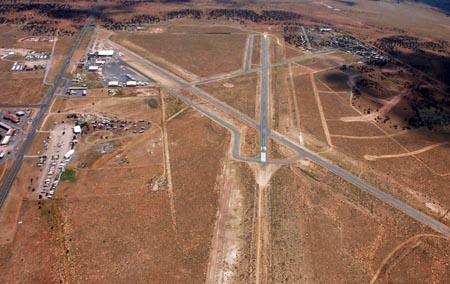
Facility Name: VALLE
City Name: GRAND CANYON
County: COCONINO
State abbrev: AZ
State Name: ARIZONA
   
Ownership: PRIVATELY OWNED
Use: OPEN TO THE PUBLIC
Owner's Name: GRAND CANYON VALLE CORP
Address: 555 S. STATE RT. 64
 VALLE, AZ 86046
Owner's Phone: 928-635-5280
  
Manager's Name: NORM GOBEIL; EMERG CTC - COCONINO SHERIFF 928-635-4487.
Address: 555 S. STATE RT. 64
 VALLE-WILLIAMS, AZ 86046
Phone: 928-635-5280; EMERG - 380-0698
   
FAA Region: WESTERN-PACIFIC
FAA Field Office: PHX
Aerial photo of K40G, Valle Airport, Grand Canyon.


Click here for full scale & interactive Sectional view of K40G


Sunrise / Sunset times for VALLE

DateSunriseSunset
04/23/24 Tuesday5:4519:09
04/24/24 Wednesday5:4419:10
04/25/24 Thursday5:4219:11
04/26/24 Friday5:4119:12
04/27/24 Saturday5:4019:13
04/28/24 Sunday5:3919:13
04/29/24 Monday5:3819:14
04/30/24 Tuesday5:3719:15
05/01/24 Wednesday5:3619:16
05/02/24 Thursday5:3519:17
05/03/24 Friday5:3419:18
05/04/24 Saturday5:3319:18
05/05/24 Sunday5:3219:19
05/06/24 Monday5:3119:20

Airport Facilities

Airport Attendance Schedule
Airport Status OPERATIONAL (This Status can change at any time - please check NOTAMS)
Airport Lighting Schedule
Airport Storage AvailableTie Downs
Extra Services AvailableNONE
Wind IndicatorYES - (unlit)
Control TowerNO
CTAF Frequency122.800
Unicom Frequency122.800
Rotating Beacon ColorWG
Segmented CircleYES
Landing FeeNO

Airport Inspection Data

Airport InspectedSTATE - performed by PRIVATE CONTRACT PERSONNEL
Inspection Date05/12/2022

Airport Services

Type of Fuel AvailableNone
Airframe Repair ServiceNone
Power Plant Repair ServiceNone

Geographic Data

LatitudeN3539.0
LongitudeW11208.9 (ESTIMATED)
Arpt Elevation5999ft (SURVEYED)
Magnetic Variation13E
25 miles Sof GRAND CANYON
Traffic Pattern Altitude
Sectional ChartPHOENIX

Aircraft Data

Operations (Reported)YearlyAvg. Daily
General Aviation Transient 10003
General Aviation Local 2001
Air Taxi 00
Commerical 00
Commuter 00
Military 2501
Aircraft based on Field
General Aviation Singles 0
General Aviation Multi 0
Jet Aircraft 0
General Aviation Helicopters 1
Military Aircraft 0
Gliders 0
Ultralights 0

FAA Services

FSS on field NO
FSS tie-in PRESCOTT
FSS Phone 1-800-WX-BRIEF
Who issues Notams PRC
Notam D service at airport YES
ARTCC Name LOS ANGELES

Federal Status

Airport Certification
Aircraft Rescue & Firefighting IndexNone
Airport of EntryNo
Custom Landing RightsNo
Joint Civil/MilitaryNo
Military Landing rightsNo

Remarks

WILDLIFE ON AND INVOF ARPT.
FOR CD CTC LA ARTCC AT 661-575-2079.
NOT MNTND IN WINTER; CALL AHEAD FOR RWY COND.
HEL TRNG INVOF ARPT - MNT 122.8 WI 5 NM.
RWY 19 FLT DMSTN 850-1000 FT E OF THR.
Airport Communications & Frequencies:
CTAF Frequency:
122.800
Unicom Frequency:
122.800
Remarks
  • APCH/DEP CTL SVC PRVDD BY LOS ANGELES ARTCC (ZLA) ON FREQS 124.85/319.2 (SELIGMAN RCAG).
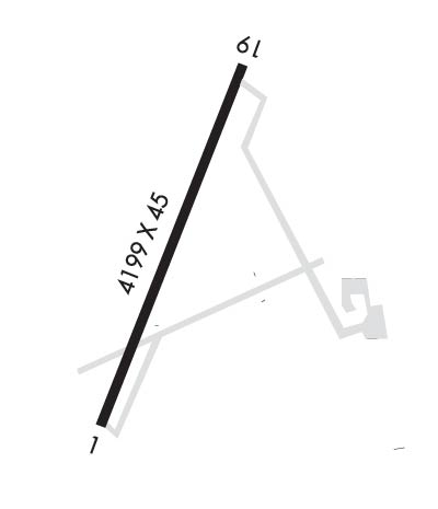
  • Runway Identifications
    Runway Identification: 01/19
    Length: 4199 ft
    Width: 45 ft
    Surface: ASPHALT-GOOD CONDITION
    Edge lights:

    Treatment: NONE

     Runway: 01   Runway: 19
    Mag heading: Mag heading: 188°
    Rwy Slope: -.24% DownRwy Slope: .24% Up
    Approach: Approach:
    Pattern: Left TrafficPattern: Left Traffic
    Markings: NONPRECISION INSTRUMENTMarkings: NONPRECISION INSTRUMENT
    Marking Condition: FAIR; CNTRLN POOR; CRACK FILLER CVRG PAINT.Marking Condition: FAIR; CNTRLN POOR; CRACK FILLER CVRG PAINT.
    Arresting Dev: Arresting Dev:
    Lat & Long: N3538.7  W11209.0Lat. & Long.: N3539.4  W11208.7
    Elev: 5998.5 ft. MSLElev: 5988.6 ft. MSL
    TCH: TCH:
    Visual Glide Path: Visual Glide Path:
    Displaced Threshold: NoDisplaced Threshold: No
    Touchdown Zone: YESTouchdown Zone: YES
    Touchdown Elev.: 5998.5 feetTouchdown Elev.: 5996.0 feet
    Visual Glide Slope: Visual Glide Slope:
    RVR Equipment: RVR Equipment:
    RVV Equipment: NORVV Equipment: NO
    Approach Lights: Approach Lights:
    REIL: NOREIL: NO
    Centerline Lights: NOCenterline Lights: NO
    Touchdown lights: NOTouchdown lights: NO
    Runway Category: Runway with a Non-precision ApproachRunway Category: Runway with a Non-precision Approach
    Declared Distances: Declared Distances:
    Comments: 10 FT ROAD 200 FT FM THR ACRS APCH AREA 250 FT EACH SIDE; 2 FT BRUSH 200 FT FM THR 90-250 FT L OF CNTRLN.Comments:
    C:/P: