Click here for more info on on SMS!

K3Y3

WINTERSET-MADISON COUNTY
WINTERSET
IA
Time Zone: Central
Lat: N 4121.8
Long: W 09401.3
Elev: 1116
Var: -02
Longest Runway: 3002
CTAF: 122.7

FBO & Flight Services info for K3Y3

FBOs: Update your Fuel Prices

WINTERSET AVPh: 515-462-1811
-
Freq: 122.7
Service
Jet
100LL
SAF
MoGas
Fuel Avail: No prist for Jet A offered here! 100LL 24hr self-serve credit card
Full        Caution: Fuel prices have not been updated in 35 days.
Last Update: 03/20/2024 09:32

Self5.466.30    
 Address: 3405 N 8TH AVE,   WINTERSET, IA 50273
If you are an FBO, call 1-203-262-1700 to update your info or email: FltPlan.Advertising@garmin.com
Advertise your FBO on FltPlan.com

Runway & Approach Info for K3Y3
Rwy
Length
Land Dist**
Approach*
  Rwy
Length
Land Dist**
Approach*
14
3002x50  2827'          
 
  
32
  3002x50  3002'          
 
 * only ILS, LOC, LDA, and SDF approaches to a specific runway are shown
** For any Declared Landing Distance Available, please see A/FD or Approach plates
Runway Weight Capability (lbs.) Help
Runway IDSingle WheelDouble WheelDouble Tandem WheelDual Double Wheel
14/32N/AN/AN/AN/A
These numbers are Advisory and are not limits.   The Airport Manager should have more accurate Weight Limits
Approach Charts
Approaches    
Current Weather/Notams
Customs Information Send updates to Support@FltPlan.com
Customs Not Available
Database effective 05/16/2024
Airport Diagram of K3Y3
Airport Diagram might not be current.

Facility Name: WINTERSET MUNI
City Name: WINTERSET
County: MADISON
State abbrev: IA
State Name: IOWA
   
Ownership: PUBLICLY OWNED
Use: OPEN TO THE PUBLIC
Owner's Name: WNTRSET ARPT AUTH; WINTERSET AIRPORT AUTHORITY
Address: 3405 NORTH 8TH AVENUE
 WINTERSET, IA 50273
Owner's Phone: 515-205-9919
  
Manager's Name: AARON ARMSTRONG
Address: 3405 NORTH 8TH AVE; WINTERSET.APMANAGER@GMAIL.COM
 WINTERSET, IA 50273
Phone: 515-205-9919
   
FAA Region: CENTRAL
FAA Field Office: NONE


Sunrise / Sunset times for WINTERSET MUNI

DateSunriseSunset
04/23/24 Tuesday6:2320:06
04/24/24 Wednesday6:2220:07
04/25/24 Thursday6:2020:08
04/26/24 Friday6:1920:09
04/27/24 Saturday6:1820:10
04/28/24 Sunday6:1620:11
04/29/24 Monday6:1520:12
04/30/24 Tuesday6:1420:13
05/01/24 Wednesday6:1220:14
05/02/24 Thursday6:1120:16
05/03/24 Friday6:1020:17
05/04/24 Saturday6:0920:18
05/05/24 Sunday6:0720:19
05/06/24 Monday6:0620:20

Airport Facilities

Airport Attendance ScheduleMON-FRI 0800-1700, SAT-SUN ON CALL
Airport Status OPERATIONAL (This Status can change at any time - please check NOTAMS)
Airport Lighting ScheduleACTVT MIRL RY 14/32 & PAPI RYS 14 & 32 - CTAF.
Airport Storage AvailableTie Downs, Hanger
Extra Services AvailableFlight Instruction, Aircraft Rental
Wind IndicatorYES - (lighted)
Control TowerNO
CTAF Frequency122.700
Unicom Frequency122.700
Rotating Beacon ColorWG
Segmented CircleNO
Landing FeeNO

Airport Inspection Data

Airport InspectedSTATE - performed by STATE AERONAUTICAL PERSONNEL
Inspection Date09/06/2023

Airport Services

Type of Fuel AvailableGrade 100LL, JET A (freeze point -40C)
Airframe Repair ServiceMAJOR
Power Plant Repair ServiceMAJOR

Geographic Data

LatitudeN4121.8
LongitudeW09401.3 (ESTIMATED)
Arpt Elevation1115ft (SURVEYED)
Magnetic Variation02E
2 miles Nof WINTERSET
Traffic Pattern Altitude800
Sectional ChartOMAHA

Aircraft Data

Operations (Reported)YearlyAvg. Daily
General Aviation Transient 349010
General Aviation Local 32609
Air Taxi 00
Commerical 00
Commuter 00
Military 00
Aircraft based on Field
General Aviation Singles 21
General Aviation Multi 2
Jet Aircraft 0
General Aviation Helicopters 0
Military Aircraft 0
Gliders 0
Ultralights 0

FAA Services

FSS on field NO
FSS tie-in FORT DODGE
FSS Phone 1-800-WX-BRIEF
Who issues Notams FOD
Notam D service at airport YES
ARTCC Name MINNEAPOLIS

Federal Status

Airport Certification
Aircraft Rescue & Firefighting IndexNone
Airport of EntryNo
Custom Landing RightsNo
Joint Civil/MilitaryNo
Military Landing rightsNo

Federal Agreements

NATIONAL PLAN OF INTEGRATED AIRPORT SYSTEMS (NPIAS)

Remarks

ULTRALIGHT ACT ON & INVOF ARPT.
RWY 32 END SAFETY AREA EXTDS 240 FT; SHARP DROP AT THAT POINT.
INADQT CLNC FOR HLDG ON THE TARND AT THE THR OF RWY 32.
RWY 32 IS CALM WIND RWY.
FOR CD CTC DES MOINES ATCT AT 515-974-8016.
RWY 14/3 2 MIRL - RWY 14/32 ENDS HAVE SIX THLD LGTS AND ALL WHITE LENSES ALONG RWY LEN.
Airport Communications & Frequencies:
CTAF Frequency:
122.700
Unicom Frequency:
122.700
DES MOINES Primary Approach Frequencies:  
123.9
360.7
DES MOINES Primary Departure Frequencies:  
123.9
360.7
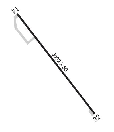
Runway Identifications
Runway Identification: 14/32
Length: 3002 ft
Width: 50 ft
Surface: ASPHALT-GOOD CONDITION
Edge lights: Non-Standard Lighting System

Treatment: NONE
Weight: PCN 6 /F/A/X/U

 Runway: 14   Runway: 32
Mag heading: 141°Mag heading: 321°
Rwy Slope: -.72% DownRwy Slope: .72% Up
Approach: Approach:
Pattern: Left TrafficPattern: Left Traffic
Markings: NONPRECISION INSTRUMENTMarkings: NONPRECISION INSTRUMENT
Marking Condition: GOODMarking Condition: GOOD
Arresting Dev: Arresting Dev:
Lat & Long: N4122.0  W09401.5Lat. & Long.: N4121.6  W09401.1
Elev: 1115.5 ft. MSLElev: 1093.8 ft. MSL
TCH: 32 ft. AGLTCH: 40 ft. AGL
Visual Glide Path: 3.00 degreesVisual Glide Path: 3.00 degrees
Displaced Threshold: 175 feetDisplaced Threshold: No
Touchdown Zone: YESTouchdown Zone: YES
Touchdown Elev.: 1115.5 feetTouchdown Elev.: 1115.5 feet
Visual Glide Slope: 2-Light PAPI on LEFT side of RunwayVisual Glide Slope: 2-Light PAPI on LEFT side of Runway
RVR Equipment: RVR Equipment:
RVV Equipment: NORVV Equipment: NO
Approach Lights: Approach Lights:
REIL: NOREIL: NO
Centerline Lights: NOCenterline Lights: NO
Touchdown lights: NOTouchdown lights: NO
Runway Category: Runway with a Non-precision ApproachRunway Category: Runway with a Non-precision Approach
Declared Distances: Declared Distances:
Obstructions: ROADObstructions: TREE
Marked: NOT Marked/LightedMarked: NOT Marked/Lighted
Clearance slope: 1:1; APCH SLOPE 6:1 FM DSPLCD THLD.Clearance slope: 20:1
Obstruction height: 15 feet AGLObstruction height: 20 feet AGL
Dist. from runway: 200 feetDist. from runway: 603 feet
Centerline offset: 45 right of centerlineCenterline offset: 210 feet right of centerline
Comments: 15 FT ROAD 140 FT FM RY ENDComments:
C:1/P: