Click here for more info on on SMS!

K3Y2

GEORGE L SCOTT MUNI
WEST UNION
IA
Time Zone: Central
Lat: N 4259.1
Long: W 09147.4
Elev: 1232
Var: +01
Longest Runway: 4149
CTAF: 122.8

FBO & Flight Services info for K3Y2

FBOs: Update your Fuel Prices

WEST UNION ARPTPh: 563-422-7702
-
Freq: 122.8
Service
Jet
100LL
SAF
MoGas
Fuel Avail: NO FUEL AVAILABLE
Full        Last Update: 04/26/2024 00:15:41

Self        
If you are an FBO, call 1-203-262-1700 to update your info or email: FltPlan.Advertising@garmin.com
Advertise your FBO on FltPlan.com

Runway & Approach Info for K3Y2
Rwy
Length
Land Dist**
Approach*
  Rwy
Length
Land Dist**
Approach*
17
4149x60  4149'          
 
  
35
  4149x60  4149'          
 
 * only ILS, LOC, LDA, and SDF approaches to a specific runway are shown
** For any Declared Landing Distance Available, please see A/FD or Approach plates
Runway Weight Capability (lbs.) Help
Runway IDSingle WheelDouble WheelDouble Tandem WheelDual Double Wheel
17/3521,00021,000N/AN/A
These numbers are Advisory and are not limits.   The Airport Manager should have more accurate Weight Limits
Approach Charts
Approaches    
Current Weather/Notams
Customs Information Send updates to Support@FltPlan.com
Customs Not Available
Database effective 05/16/2024
Airport Diagram of K3Y2
Airport Diagram might not be current.

Facility Name: GEORGE L SCOTT MUNI
City Name: WEST UNION
County: FAYETTE
State abbrev: IA
State Name: IOWA
   
Ownership: PUBLICLY OWNED
Use: OPEN TO THE PUBLIC
Owner's Name: CITY OF WEST UNION
Address: P.O. BOX 151
 WEST UNION, IA 52175-0151
Owner's Phone: 563-422-3908
  
Manager's Name: GREG NOVAK
Address: 10184 240TH STREET
 WEST UNION, IA 52175
Phone: 563-422-8465
   
FAA Region: CENTRAL
FAA Field Office: NONE


Sunrise / Sunset times for GEORGE L SCOTT MUNI

DateSunriseSunset
04/25/24 Thursday6:0820:02
04/26/24 Friday6:0720:03
04/27/24 Saturday6:0620:04
04/28/24 Sunday6:0420:06
04/29/24 Monday6:0320:07
04/30/24 Tuesday6:0120:08
05/01/24 Wednesday6:0020:09
05/02/24 Thursday5:5920:10
05/03/24 Friday5:5720:11
05/04/24 Saturday5:5620:12
05/05/24 Sunday5:5520:14
05/06/24 Monday5:5320:15
05/07/24 Tuesday5:5220:16
05/08/24 Wednesday5:5120:17

Airport Facilities

Airport Attendance ScheduleUNATTENDED
Airport Status OPERATIONAL (This Status can change at any time - please check NOTAMS)
Airport Lighting ScheduleACTVT PAPI RYS 17 & 35 - CTAF.
Airport Storage AvailableTie Downs, Hanger
Extra Services AvailableNONE
Wind IndicatorYES - (lighted)
Control TowerNO
CTAF Frequency122.800
Unicom Frequency122.800
Rotating Beacon ColorWG
Segmented CircleNO
Landing FeeNO

Airport Inspection Data

Airport InspectedSTATE - performed by STATE AERONAUTICAL PERSONNEL
Inspection Date07/20/2023

Airport Services

Type of Fuel AvailableGrade 100LL, JET A (freeze point -40C); -10AVBL 24-7 SELF SVC.
Airframe Repair ServiceNONE
Power Plant Repair ServiceNONE

Geographic Data

LatitudeN4259.1
LongitudeW09147.4 (ESTIMATED)
Arpt Elevation1231ft (SURVEYED)
Magnetic Variation01W
1 miles NEof WEST UNION
Traffic Pattern Altitude
Sectional ChartCHICAGO

Aircraft Data

Operations (Reported)YearlyAvg. Daily
General Aviation Transient 23566
General Aviation Local 14944
Air Taxi 00
Commerical 00
Commuter 00
Military 00
Aircraft based on Field
General Aviation Singles 6
General Aviation Multi 0
Jet Aircraft 0
General Aviation Helicopters 0
Military Aircraft 0
Gliders 1
Ultralights 0

FAA Services

FSS on field NO
FSS tie-in FORT DODGE
FSS Phone 1-800-WX-BRIEF
Who issues Notams FOD
Notam D service at airport YES
ARTCC Name MINNEAPOLIS

Federal Status

Airport Certification
Aircraft Rescue & Firefighting IndexNone
Airport of EntryNo
Custom Landing RightsNo
Joint Civil/MilitaryNo
Military Landing rightsNo

Federal Agreements

NATIONAL PLAN OF INTEGRATED AIRPORT SYSTEMS (NPIAS)

Remarks

RY 17 PAPI UNUSBL BYD 7 DEG RIGHT OF CNTRLN.
FOR CD CTC MINNEAPOLIS ARTCC AT 651-463-5588.
Airport Communications & Frequencies:
CTAF Frequency:
122.800
Unicom Frequency:
122.800
Remarks
  • APCH/DEP SVC PRVDD BY MINNAEPOLIS ARTCC ON FREQ 118.85 (LA CROSSE RCAG).
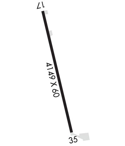
  • Runway Identifications
    Runway Identification: 17/35
    Length: 4149 ft
    Width: 60 ft
    Surface: CONCRETE-GOOD CONDITION
    Edge lights: Medium Intensity

    Treatment: NONE
    Weight: PCN 7 /R/C/W/U

     Runway: 17   Runway: 35
    Mag heading: 174°Mag heading: 354°
    Rwy Slope: -.86% DownRwy Slope: .86% Up
    Approach: Approach:
    Pattern: Left TrafficPattern: Left Traffic
    Markings: NONPRECISION INSTRUMENTMarkings: NONPRECISION INSTRUMENT
    Marking Condition: GOODMarking Condition: GOOD
    Arresting Dev: Arresting Dev:
    Lat & Long: N4259.5  W09147.5Lat. & Long.: N4258.8  W09147.4
    Elev: 1231.8 ft. MSLElev: 1196.1 ft. MSL
    TCH: 41 ft. AGLTCH: 38 ft. AGL
    Visual Glide Path: 3.00 degreesVisual Glide Path: 3.00 degrees
    Displaced Threshold: NoDisplaced Threshold: No
    Touchdown Zone: YESTouchdown Zone: YES
    Touchdown Elev.: 1231.8 feetTouchdown Elev.: 1223.2 feet
    Visual Glide Slope: 2-Light PAPI on LEFT side of Runway; PAPI NSTD; KEY CTAF 5 TIMES.Visual Glide Slope: 2-Light PAPI on LEFT side of Runway; PAPI NSTD; KEY CTAF 5 TIMES.
    RVR Equipment: RVR Equipment:
    RVV Equipment: NORVV Equipment: NO
    Approach Lights: Approach Lights:
    REIL: NOREIL: NO
    Centerline Lights: NOCenterline Lights: NO
    Touchdown lights: NOTouchdown lights: NO
    Runway Category: Runway with a Non-precision Approach having visibility minimums greater than 3/4 mileRunway Category: Runway with a Non-precision Approach having visibility minimums greater than 3/4 mile
    Declared Distances: Declared Distances:
    C:/P: