Approach Charts
| FltPlan does not have IFR approach charts available for K3W7. |
Current Weather/Notams (Metars, TAFs, Notams, NWS Forecast, PIREPS, and nearby weather)
Customs Information Send updates to Support@FltPlan.com
Customs Not Available
Database effective 05/16/2024
Airport Diagram might not be current.
|
| Facility Name: | GRAND COULEE DAM |
| City Name: | ELECTRIC CITY |
| County: | GRANT |
| State abbrev: | WA |
| State Name: | WASHINGTON |
| | |
| Ownership: | PUBLICLY OWNED |
| Use: | OPEN TO THE PUBLIC |
| Owner's Name: | GRANT CO PORT DIST NR 7 |
| Address: | P.O. BOX 616 |
| | GRAND COULEE, WA 99133 |
| Owner's Phone: | (509) 633-3018 |
| | |
| Manager's Name: | ROBERT BABLER |
| Address: | P.O. BOX 182 |
| | GRAND COULEE, WA 99133 |
| Phone: | 509-631-4797 |
| | |
| FAA Region: | NORTHWEST MOUNTAIN |
| FAA Field Office: | SEA |
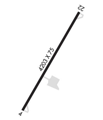
Runway Identifications
Runway Identification: 04/22Length: 4203 ft
Width: 75 ft
Surface: ASPHALT-GOOD CONDITION
Edge lights: Medium IntensityTreatment: NONE
| | Runway: 04 | | Runway: 22 |
| Mag heading: | 36° | Mag heading: | 216° |
| Rwy Slope: | .01% Up | Rwy Slope: | -.01% Down |
| Approach: | | Approach: | |
| Pattern: | Left Traffic | Pattern: | Right Traffic |
| Markings: | BASIC | Markings: | BASIC |
| Marking Condition: | GOOD | Marking Condition: | GOOD |
| Arresting Dev: | | Arresting Dev: | |
| Lat & Long: | N4755.1 W11905.4 | Lat. & Long.: | N4755.5 W11904.6 |
| Elev: | 1588.7 ft. MSL | Elev: | 1589.0 ft. MSL |
| TCH: | | TCH: | |
| Visual Glide Path: | | Visual Glide Path: | |
| Displaced Threshold: | No | Displaced Threshold: | No |
| Touchdown Zone: | YES | Touchdown Zone: | YES |
| Touchdown Elev.: | 1593.1 feet | Touchdown Elev.: | 1593.1 feet |
| Visual Glide Slope: | | Visual Glide Slope: | |
| RVR Equipment: | | RVR Equipment: | |
| RVV Equipment: | NO | RVV Equipment: | NO |
| Approach Lights: | | Approach Lights: | |
| REIL: | NO | REIL: | NO |
| Centerline Lights: | NO | Centerline Lights: | NO |
| Touchdown lights: | NO | Touchdown lights: | NO |
| Runway Category: | Runway with a Visual Approach | Runway Category: | Runway with a Visual Approach |
| Declared Distances: | | Declared Distances: | |
| Obstructions: | HILL | Obstructions: | GND |
| Marked: | NOT Marked/Lighted | Marked: | NOT Marked/Lighted |
| Clearance slope: | 17:1 | Clearance slope: | 33:1 |
| Obstruction height: | 490 feet AGL | Obstruction height: | 30 feet AGL |
| Dist. from runway: | 9000 feet | Dist. from runway: | 1195 feet |
| Centerline offset: | | Centerline offset: | |
| Comments: | 15 FT TREE 61 FT FM THR, 73 FT L & DITCH 27 FT FM THR, 91 FT R. | Comments: | BRUSH 79 FT R; SLP & BRUSH 100 FT FM THR, 99 FT L. |

