
| ||||||||||||||||||||||||||||||||
| ||||||||||||||||||||||||||||||||
| Rwy | Rwy | |||||||
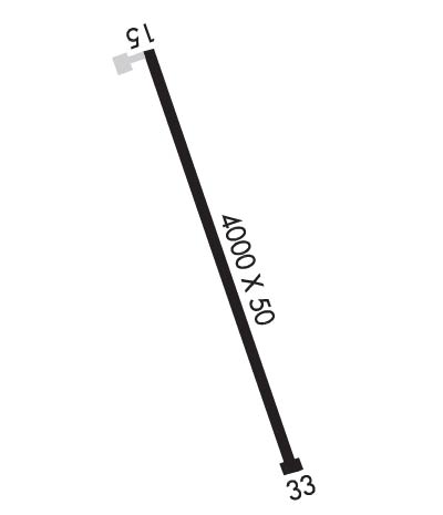
| 4000x50 | 4000' | 4000x50 | 4000' | |||||
| Runway ID | Single Wheel | Double Wheel | Double Tandem Wheel | Dual Double Wheel |
| 15/33 | 12,500 | N/A | N/A | N/A |
| These numbers are Advisory and are not limits. The Airport Manager should have more accurate Weight Limits | ||||
| FltPlan does not have IFR approach charts available for K3V0. |
 Airport Diagram might not be current. | |
| Facility Name: | CUSTER STATE PARK |
| City Name: | FAIRBURN |
| County: | CUSTER |
| State abbrev: | SD |
| State Name: | SOUTH DAKOTA |
| Ownership: | PUBLICLY OWNED |
| Use: | OPEN TO THE PUBLIC |
| Owner's Name: | STATE OF SOUTH DAKOTA |
| Address: | |
| PIERRE, SD 57501 | |
| Owner's Phone: | |
| Manager's Name: | MATT SNYDER - CUSTER STATE PARK |
| Address: | 13329 US HWY 16A |
| CUSTER, SD 57730-1525 | |
| Phone: | 605-255-4800 |
| FAA Region: | GREAT LAKES |
| FAA Field Office: | DMA |
| Date | Sunrise | Sunset |
|---|---|---|
| 04/22/24 Monday | 5:58 | 19:46 |
| 04/23/24 Tuesday | 5:56 | 19:48 |
| 04/24/24 Wednesday | 5:55 | 19:49 |
| 04/25/24 Thursday | 5:53 | 19:50 |
| 04/26/24 Friday | 5:52 | 19:51 |
| 04/27/24 Saturday | 5:50 | 19:52 |
| 04/28/24 Sunday | 5:49 | 19:53 |
| 04/29/24 Monday | 5:47 | 19:55 |
| 04/30/24 Tuesday | 5:46 | 19:56 |
| 05/01/24 Wednesday | 5:44 | 19:57 |
| 05/02/24 Thursday | 5:43 | 19:58 |
| 05/03/24 Friday | 5:42 | 19:59 |
| 05/04/24 Saturday | 5:40 | 20:01 |
| 05/05/24 Sunday | 5:39 | 20:02 |
| Airport Attendance Schedule | UNATTENDED |
| Airport Status | OPERATIONAL (This Status can change at any time - please check NOTAMS) |
| Airport Lighting Schedule | ACTVT LIRL RY 15/33 - CTAF. |
| Airport Storage Available | Tie Downs, Hanger |
| Extra Services Available | NONE |
| Wind Indicator | YES - (lighted) |
| Control Tower | NO |
| CTAF Frequency | 122.900 |
| Unicom Frequency | |
| Rotating Beacon Color | WG |
| Segmented Circle | YES |
| Landing Fee | NO |
| Airport Inspected | STATE - performed by STATE AERONAUTICAL PERSONNEL |
| Inspection Date | 06/13/2023 |
| Type of Fuel Available | None |
| Airframe Repair Service | NONE |
| Power Plant Repair Service | NONE |
| Latitude | N4343.5 |
| Longitude | W10321.0 (ESTIMATED) |
| Arpt Elevation | 3980ft (SURVEYED) |
| Magnetic Variation | 11E |
| 6 miles NW | of FAIRBURN |
| Traffic Pattern Altitude | |
| Sectional Chart | CHEYENNE |
| Operations (Reported) | Yearly | Avg. Daily |
|---|---|---|
| General Aviation Transient | 360 | 1 |
| General Aviation Local | 0 | 0 |
| Air Taxi | 0 | 0 |
| Commerical | 0 | 0 |
| Commuter | 0 | 0 |
| Military | 200 | 1 |
| Aircraft based on Field | |
|---|---|
| General Aviation Singles | 0 |
| General Aviation Multi | 0 |
| Jet Aircraft | 0 |
| General Aviation Helicopters | 0 |
| Military Aircraft | 0 |
| Gliders | 0 |
| Ultralights | 0 |
| FSS on field | NO |
| FSS tie-in | HURON |
| FSS Phone | 1-800-WX-BRIEF |
| Who issues Notams | HON |
| Notam D service at airport | YES |
| ARTCC Name | DENVER |
| Airport Certification | |
| Aircraft Rescue & Firefighting Index | None |
| Airport of Entry | No |
| Custom Landing Rights | No |
| Joint Civil/Military | No |
| Military Landing rights | No |
| GRANT AGREEMENT HAS EXPIRED; HOWEVER, AGREEMENT REMAINS IN EFFECT FOR THIS FACILITY AS LONG AS IT IS PUBLIC USE. |
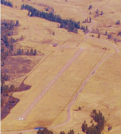
| WILDLIFE ON & INVOF ARPT, BE ALERT. |
| CHECK DENSITY ALT & LEAN MIXTURE FOR BEST ENGINE OPERATION AT THIS ALT. |
| RISING TERRAIN TO THE NORTH. |
| BE ALERT FOR INCREASED RY GRADIENT WHEN TAKING OFF ON RY 33, DENSITY ALT AND RISING TERRAIN MAY NECESSITATE A DEPARTURE FM RY 15 FOR SAFE FLIGHT. |
| FOR CD CTC ELLSWORTH APCH AT 605-385-6198, WHEN APCH CLSD CTC DENVER ARTCC AT 303-651-4257. |
| HIGH VOL OF ACFT OPRNG INVOF OF MT RUSHMORE AND CRAZY HORSE MONUMENTS AT OR BLW 7500 FT; PILOTS ARE ADVISED TO MNT 122.85 FOR TFC ADVISORIES. |
| RWY 15/3 3 MARKINGS FADED. |
| Runway: 15 | Runway: 33 | ||
| Mag heading: | N/A | Mag heading: | N/A |
| Rwy Slope: | -1.79% Down | Rwy Slope: | 1.79% Up |
| Approach: | Approach: | ||
| Pattern: | Left Traffic | Pattern: | Right Traffic |
| Markings: | BASIC | Markings: | BASIC |
| Marking Condition: | FAIR | Marking Condition: | FAIR |
| Arresting Dev: | Arresting Dev: | ||
| Lat & Long: | N4343.8 W10321.2 | Lat. & Long.: | N4343.2 W10320.8 |
| Elev: | 3979.2 ft. MSL | Elev: | 3907.5 ft. MSL |
| TCH: | TCH: | ||
| Visual Glide Path: | Visual Glide Path: | ||
| Displaced Threshold: | No | Displaced Threshold: | No |
| Touchdown Zone: | NO | Touchdown Zone: | NO |
| Touchdown Elev.: | Touchdown Elev.: | ||
| Visual Glide Slope: | Visual Glide Slope: | ||
| RVR Equipment: | RVR Equipment: | ||
| RVV Equipment: | NO | RVV Equipment: | NO |
| Approach Lights: | Approach Lights: | ||
| REIL: | NO | REIL: | NO |
| Centerline Lights: | NO | Centerline Lights: | NO |
| Touchdown lights: | NO | Touchdown lights: | NO |
| Runway Category: | Runway with a Visual Approach | Runway Category: | Runway with a Visual Approach |
| Declared Distances: | Declared Distances: | ||
| Obstructions: | TREES | Obstructions: | |
| Marked: | NOT Marked/Lighted | Marked: | |
| Clearance slope: | 21:1 | Clearance slope: | 50:1 |
| Obstruction height: | 32 feet AGL | Obstruction height: | |
| Dist. from runway: | 867 feet | Dist. from runway: | |
| Centerline offset: | 63 left of centerline | Centerline offset: | |
| Comments: | Comments: |