Approach Charts
| FltPlan does not have IFR approach charts available for K3U7. |
Current Weather/Notams (Metars, TAFs, Notams, NWS Forecast, PIREPS, and nearby weather)
Customs Information Send updates to Support@FltPlan.com
Customs Not Available
Database effective 05/16/2024
Airport Diagram might not be current.
|
| Facility Name: | BENCHMARK |
| City Name: | AUGUSTA |
| County: | LEWIS AND CLARK |
| State abbrev: | MT |
| State Name: | MONTANA |
| | |
| Ownership: | PUBLICLY OWNED |
| Use: | OPEN TO THE PUBLIC |
| Owner's Name: | U S FOREST SERVICE |
| Address: | LEWIS & CLARK NATNL FOREST |
| | CHOTEAU, MT 59422 |
| Owner's Phone: | 406-791-7700 |
| | |
| Manager's Name: | JAY LINDGREN |
| Address: | HELENA & LEWIS & CLARK NAT FORESTS, 2880 SKYWAY DRIVE |
| | HELENA, MT 59602 |
| Phone: | (406) 495-3832; MANAGER CELL PHONE NUMBER 406-461-1652 |
| | |
| FAA Region: | NORTHWEST MOUNTAIN |
| FAA Field Office: | HLN |
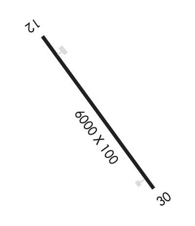
Runway Identifications
Runway Identification: 12/30Length: 6000 ft
Width: 100 ft
Surface: ASPHALT-FAIR CONDITION
Edge lights: Treatment: NONE
| | Runway: 12 | | Runway: 30 |
| Mag heading: | 122° | Mag heading: | 302° |
| Rwy Slope: | 1.97% Up | Rwy Slope: | -1.97% Down |
| Approach: | | Approach: | |
| Pattern: | Left Traffic | Pattern: | Left Traffic |
| Markings: | BASIC | Markings: | BASIC |
| Marking Condition: | FAIR | Marking Condition: | FAIR |
| Arresting Dev: | | Arresting Dev: | |
| Lat & Long: | N4729.3 W11252.8 | Lat. & Long.: | N4728.5 W11251.9 |
| Elev: | 5316.0 ft. MSL | Elev: | 5434.0 ft. MSL |
| TCH: | | TCH: | |
| Visual Glide Path: | | Visual Glide Path: | |
| Displaced Threshold: | No | Displaced Threshold: | No |
| Touchdown Zone: | NO | Touchdown Zone: | NO |
| Touchdown Elev.: | | Touchdown Elev.: | |
| Visual Glide Slope: | | Visual Glide Slope: | |
| RVR Equipment: | | RVR Equipment: | |
| RVV Equipment: | NO | RVV Equipment: | NO |
| Approach Lights: | | Approach Lights: | |
| REIL: | NO | REIL: | NO |
| Centerline Lights: | NO | Centerline Lights: | NO |
| Touchdown lights: | NO | Touchdown lights: | NO |
| Runway Category: | Runway with a Visual Approach | Runway Category: | Runway with a Visual Approach |
| Declared Distances: | | Declared Distances: | |
| Obstructions: | TREES; +65' TREES 0' TO 150' R, 2150' FM RY END, 33:1 TO RY END. | Obstructions: | TREES |
| Marked: | NOT Marked/Lighted | Marked: | NOT Marked/Lighted |
| Clearance slope: | 5:1 | Clearance slope: | 7:1 |
| Obstruction height: | 33 feet AGL | Obstruction height: | 34 feet AGL |
| Dist. from runway: | 372 feet; +58' TREES ON CENTERLINE. | Dist. from runway: | 461 feet; +250' TREES ON CENTERLINE. |
| Centerline offset: | | Centerline offset: | |
| Comments: | | Comments: | |

