Current Weather/Notams (Metars, TAFs, Notams, NWS Forecast, PIREPS, and nearby weather)
Customs Information Send updates to Support@FltPlan.com
Customs Not Available
Database effective 04/18/2024
Airport Diagram might not be current.
|
| Facility Name: | BOWMAN FLD |
| City Name: | ANACONDA |
| County: | DEER LODGE |
| State abbrev: | MT |
| State Name: | MONTANA |
| | |
| Ownership: | PUBLICLY OWNED |
| Use: | OPEN TO THE PUBLIC |
| Owner's Name: | ANACONDA DEERLODGE COUNTY |
| Address: | 800 S. MAIN ST |
| | ANACONDA, MT 59711 |
| Owner's Phone: | 406-563-4000 |
| | |
| Manager's Name: | MONTE BELGARDE |
| Address: | 800 S MAIN ST |
| | ANACONDA, MT 59711 |
| Phone: | 406-490-3627 |
| | |
| FAA Region: | NORTHWEST MOUNTAIN |
| FAA Field Office: | HLN |
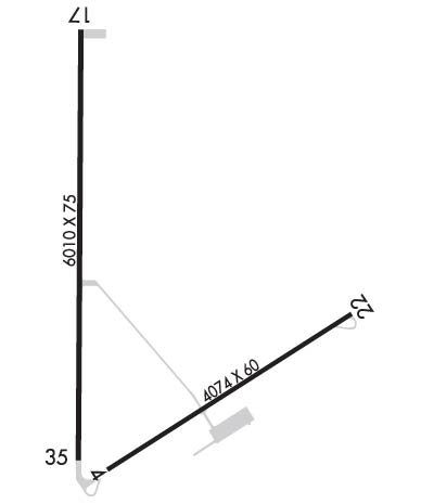
Runway Identifications
Runway Identification: 04/22Length: 4074 ft
Width: 60 ft
Surface: ASPHALT
Edge lights: Medium IntensityTreatment: NONE
| | Runway: 04 | | Runway: 22 |
| Mag heading: | 43° | Mag heading: | 223° |
| Rwy Slope: | -1.00% Down | Rwy Slope: | 1.00% Up |
| Approach: | | Approach: | |
| Pattern: | Left Traffic | Pattern: | Left Traffic |
| Markings: | BASIC | Markings: | BASIC |
| Marking Condition: | GOOD | Marking Condition: | GOOD |
| Arresting Dev: | | Arresting Dev: | |
| Lat & Long: | N4608.8 W11252.2 | Lat. & Long.: | N4609.2 W11251.4 |
| Elev: | 5029.8 ft. MSL | Elev: | 4989.0 ft. MSL |
| TCH: | 44 ft. AGL | TCH: | 22 ft. AGL |
| Visual Glide Path: | 3.25 degrees | Visual Glide Path: | 3.00 degrees |
| Displaced Threshold: | No | Displaced Threshold: | No |
| Touchdown Zone: | YES | Touchdown Zone: | YES |
| Touchdown Elev.: | 5029.8 feet | Touchdown Elev.: | 5019.1 feet |
| Visual Glide Slope: | 2-Light PAPI on LEFT side of Runway | Visual Glide Slope: | 2-Light PAPI on LEFT side of Runway |
| RVR Equipment: | | RVR Equipment: | |
| RVV Equipment: | NO | RVV Equipment: | NO |
| Approach Lights: | | Approach Lights: | |
| REIL: | NO | REIL: | NO |
| Centerline Lights: | NO | Centerline Lights: | NO |
| Touchdown lights: | NO | Touchdown lights: | NO |
| Runway Category: | Runway with a Visual Approach | Runway Category: | Runway with a Visual Approach |
| Declared Distances: | | Declared Distances: | |
Runway Identification: 17/35Length: 6010 ft
Width: 75 ft
Surface: ASPHALT
Edge lights: Medium IntensityTreatment: NONE
| | Runway: 17 | | Runway: 35 |
| Mag heading: | 166° | Mag heading: | 346° |
| Rwy Slope: | .57% Up | Rwy Slope: | -.57% Down |
| Approach: | | Approach: | |
| Pattern: | Left Traffic | Pattern: | Right Traffic |
| Markings: | NONPRECISION INSTRUMENT | Markings: | NONPRECISION INSTRUMENT |
| Marking Condition: | GOOD | Marking Condition: | GOOD |
| Arresting Dev: | | Arresting Dev: | |
| Lat & Long: | N4609.8 W11252.3 | Lat. & Long.: | N4608.8 W11252.3 |
| Elev: | 4998.2 ft. MSL | Elev: | 5032.6 ft. MSL |
| TCH: | 40 ft. AGL | TCH: | 40 ft. AGL |
| Visual Glide Path: | 3.00 degrees | Visual Glide Path: | 3.00 degrees |
| Displaced Threshold: | No | Displaced Threshold: | No |
| Touchdown Zone: | YES | Touchdown Zone: | YES |
| Touchdown Elev.: | 5011.1 feet | Touchdown Elev.: | 5032.6 feet |
| Visual Glide Slope: | 2-Light PAPI on LEFT side of Runway | Visual Glide Slope: | 2-Light PAPI on LEFT side of Runway |
| RVR Equipment: | | RVR Equipment: | |
| RVV Equipment: | NO | RVV Equipment: | NO |
| Approach Lights: | | Approach Lights: | |
| REIL: | NO | REIL: | NO |
| Centerline Lights: | NO | Centerline Lights: | NO |
| Touchdown lights: | NO | Touchdown lights: | NO |
| Runway Category: | Runway with a Visual Approach | Runway Category: | Runway with a Visual Approach |
| Declared Distances: | | Declared Distances: | |
| Obstructions: | | Obstructions: | TREES |
| Marked: | | Marked: | NOT Marked/Lighted |
| Clearance slope: | 20:1 | Clearance slope: | 16:1 |
| Obstruction height: | | Obstruction height: | 55 feet AGL |
| Dist. from runway: | | Dist. from runway: | 1100 feet |
| Centerline offset: | | Centerline offset: | |
| Comments: | | Comments: | |

