Current Weather/Notams (Metars, TAFs, Notams, NWS Forecast, PIREPS, and nearby weather)
Customs Information Send updates to Support@FltPlan.com
Customs Not Available
Database effective 05/16/2024
Airport Diagram might not be current.
|
| Facility Name: | JERRY TYLER MEML |
| City Name: | NILES |
| County: | BERRIEN |
| State abbrev: | MI |
| State Name: | MICHIGAN |
| | |
| Ownership: | PUBLICLY OWNED |
| Use: | OPEN TO THE PUBLIC |
| Owner's Name: | CITY OF NILES |
| Address: | 333 N 2ND ST STE 301 |
| | NILES, MI 49120-2258 |
| Owner's Phone: | 269-683-4700 |
| | |
| Manager's Name: | JOSEPH RAY |
| Address: | 333 N 2ND ST STE 301 |
| | NILES, MI 49120-2258 |
| Phone: | 269-240-8025 |
| | |
| FAA Region: | GREAT LAKES |
| FAA Field Office: | DET |
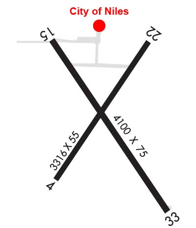
Runway Identifications
Runway Identification: 04/22Length: 3316 ft
Width: 55 ft
Surface: ASPHALT-POOR CONDITION
Edge lights: Treatment: NONE
| | Runway: 04 | | Runway: 22 |
| Mag heading: | 39° | Mag heading: | 219° |
| Rwy Slope: | .15% Up | Rwy Slope: | -.15% Down |
| Approach: | | Approach: | |
| Pattern: | Left Traffic | Pattern: | Left Traffic |
| Markings: | NONE | Markings: | NONE |
| Marking Condition: | | Marking Condition: | |
| Arresting Dev: | | Arresting Dev: | |
| Lat & Long: | N4150.0 W08613.7 | Lat. & Long.: | N4150.4 W08613.3 |
| Elev: | 736.9 ft. MSL | Elev: | 741.9 ft. MSL |
| TCH: | | TCH: | |
| Visual Glide Path: | | Visual Glide Path: | |
| Displaced Threshold: | 898 feet | Displaced Threshold: | 750 feet |
| Touchdown Zone: | YES | Touchdown Zone: | YES |
| Touchdown Elev.: | 741.9 feet | Touchdown Elev.: | 741.9 feet |
| Visual Glide Slope: | | Visual Glide Slope: | |
| RVR Equipment: | | RVR Equipment: | |
| RVV Equipment: | NO | RVV Equipment: | NO |
| Approach Lights: | | Approach Lights: | |
| REIL: | NO | REIL: | NO |
| Centerline Lights: | NO | Centerline Lights: | NO |
| Touchdown lights: | NO | Touchdown lights: | NO |
| Runway Category: | Runway with a Visual Approach | Runway Category: | Runway with a Visual Approach |
| Declared Distances: | | Declared Distances: | |
| Obstructions: | TREE | Obstructions: | TREES |
| Marked: | NOT Marked/Lighted | Marked: | NOT Marked/Lighted |
| Clearance slope: | CTLG OBSTN EXCEEDS A 45 DEG SLP. | Clearance slope: | 3:1; APCH RATIO 16:1 TO DTHR OVR 80 FT TREES, 1320 FT DIST, 255 FT R. |
| Obstruction height: | 13 feet AGL | Obstruction height: | 66 feet AGL |
| Dist. from runway: | 200 feet | Dist. from runway: | 454 feet |
| Centerline offset: | 110 left of centerline | Centerline offset: | 70 feet right of centerline |
| Comments: | 13 FT TREE, 199 FT DIST, 110 FT L. | Comments: | |
Runway Identification: 15/33Length: 4100 ft
Width: 75 ft
Surface: ASPHALT-POOR CONDITION
Edge lights: Medium IntensityTreatment: NONE
| | Runway: 15 | | Runway: 33 |
| Mag heading: | 151° | Mag heading: | 331° |
| Rwy Slope: | .22% Up | Rwy Slope: | -.22% Down |
| Approach: | | Approach: | |
| Pattern: | Left Traffic | Pattern: | Left Traffic |
| Markings: | BASIC | Markings: | BASIC |
| Marking Condition: | GOOD | Marking Condition: | GOOD |
| Arresting Dev: | | Arresting Dev: | |
| Lat & Long: | N4150.4 W08613.7 | Lat. & Long.: | N4149.9 W08613.2 |
| Elev: | 741.4 ft. MSL | Elev: | 750.4 ft. MSL |
| TCH: | 35 ft. AGL | TCH: | 37 ft. AGL |
| Visual Glide Path: | 4.00 degrees | Visual Glide Path: | 4.00 degrees |
| Displaced Threshold: | 300 feet | Displaced Threshold: | No |
| Touchdown Zone: | YES | Touchdown Zone: | YES |
| Touchdown Elev.: | 741.8 feet | Touchdown Elev.: | 750.4 feet |
| Visual Glide Slope: | 4-Light PAPI on LEFT side of Runway; PAPI UNUSBL BYD 5 DEGS LEFT OR RIGHT OF CNTRLN. | Visual Glide Slope: | 4-Light PAPI on LEFT side of Runway; PAPI UNUSBL BYD 3 DEGS LEFT OR RIGHT OF CNTRLN. |
| RVR Equipment: | | RVR Equipment: | |
| RVV Equipment: | NO | RVV Equipment: | NO |
| Approach Lights: | | Approach Lights: | |
| REIL: | YES | REIL: | YES |
| Centerline Lights: | NO | Centerline Lights: | NO |
| Touchdown lights: | NO | Touchdown lights: | NO |
| Runway Category: | Runway with a Non-precision Approach | Runway Category: | Runway with a Non-precision Approach |
| Declared Distances: | | Declared Distances: | |
| Obstructions: | TREE | Obstructions: | TREES |
| Marked: | LIGHTED | Marked: | NOT Marked/Lighted |
| Clearance slope: | 4:1; APCH RATIO 12:1 TO DTHR OVR 63 FT TREE, 791 FT DIST, 270 FT R. | Clearance slope: | CTLG OBSTN EXCEEDS A 45 DEG SLP. |
| Obstruction height: | 63 feet AGL | Obstruction height: | 45 feet AGL |
| Dist. from runway: | 502 feet | Dist. from runway: | 200 feet |
| Centerline offset: | 250 left of centerline | Centerline offset: | 240 feet right of centerline |
| Comments: | | Comments: | |


