Approach Charts
| FltPlan does not have IFR approach charts available for K3T9. |
Current Weather/Notams (Metars, TAFs, Notams, NWS Forecast, PIREPS, and nearby weather)
Customs Information Send updates to Support@FltPlan.com
Customs Not Available
Database effective 04/18/2024
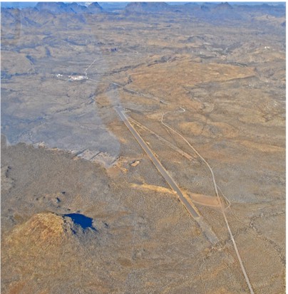
| Facility Name: | BIG BEND RANCH STATE PARK |
| City Name: | PRESIDIO |
| County: | PRESIDIO |
| State abbrev: | TX |
| State Name: | TEXAS |
| | |
| Ownership: | PUBLICLY OWNED |
| Use: | OPEN TO THE PUBLIC |
| Owner's Name: | PARKS & WILDLIFE DEPT |
| Address: | 4200 SMITH SCHOOL RD |
| | AUSTIN, TX 78744 |
| Owner's Phone: | 512-389-4802 |
| | |
| Manager's Name: | DAVID RENNINGER II; PARK SUPERINTENDENT. |
| Address: | 1900 SOUTH SAUCEDA RANCH RD |
| | MARFA, TX 79843 |
| Phone: | 432-358-4444; EXT 224. 432-295-0888 CELL. |
| | |
| FAA Region: | SOUTHWEST |
| FAA Field Office: | TEX |
Runway Identifications
Runway Identification: 08/26Length: 5500 ft
Width: 80 ft
Surface: ASPHALT-GOOD CONDITION
Edge lights: Treatment: NONE
| | Runway: 08 | | Runway: 26 |
| Mag heading: | 81° | Mag heading: | 261° |
| Rwy Slope: | .00% | Rwy Slope: | .00% |
| Approach: | | Approach: | |
| Pattern: | Left Traffic | Pattern: | Left Traffic |
| Markings: | | Markings: | |
| Marking Condition: | | Marking Condition: | |
| Arresting Dev: | | Arresting Dev: | |
| Lat & Long: | N2928.3 W10356.7 | Lat. & Long.: | N2928.3 W10355.7 |
| Elev: | 4250.0 ft. MSL | Elev: | 4250.0 ft. MSL |
| TCH: | | TCH: | |
| Visual Glide Path: | | Visual Glide Path: | |
| Displaced Threshold: | No | Displaced Threshold: | No |
| Touchdown Zone: | NO | Touchdown Zone: | NO |
| Touchdown Elev.: | | Touchdown Elev.: | |
| Visual Glide Slope: | | Visual Glide Slope: | |
| RVR Equipment: | | RVR Equipment: | |
| RVV Equipment: | NO | RVV Equipment: | NO |
| Approach Lights: | | Approach Lights: | |
| REIL: | NO | REIL: | NO |
| Centerline Lights: | NO | Centerline Lights: | NO |
| Touchdown lights: | NO | Touchdown lights: | NO |
| Runway Category: | Runway with a Visual Approach | Runway Category: | Runway with a Visual Approach |
| Declared Distances: | | Declared Distances: | |
| Obstructions: | BRUSH; HILLS SURROUNDING ARPT. | Obstructions: | BRUSH |
| Marked: | NOT Marked/Lighted | Marked: | NOT Marked/Lighted |
| Clearance slope: | 10 FT BRUSH. | Clearance slope: | |
| Obstruction height: | 10 feet AGL | Obstruction height: | 10 feet AGL |
| Dist. from runway: | 200 feet | Dist. from runway: | 200 feet |
| Centerline offset: | | Centerline offset: | |
| Comments: | 10 FT BRUSH | Comments: | 10 FT SCATTERED BRUSH FM THLD TO 200 FT FM THLD AND TO 125 FT LEFT AND RIGHT OF CENTERLINE. |