Current Weather/Notams (Metars, TAFs, Notams, NWS Forecast, PIREPS, and nearby weather)
Customs Information Send updates to Support@FltPlan.com
Customs Not Available
Database effective 04/18/2024
Airport Diagram might not be current.
|
| Facility Name: | FAYETTE RGNL AIR CENTER |
| City Name: | LA GRANGE |
| County: | FAYETTE |
| State abbrev: | TX |
| State Name: | TEXAS |
| | |
| Ownership: | PUBLICLY OWNED |
| Use: | OPEN TO THE PUBLIC |
| Owner's Name: | FAYETTE COUNTY |
| Address: | COUNTY COURTHOUSE |
| | LA GRANGE, TX 78945 |
| Owner's Phone: | 979-968-6469 |
| | |
| Manager's Name: | DEBRA MADDOX |
| Address: | 850 AIRPORT ROAD |
| | LA GRANGE, TX 78945 |
| Phone: | 979-242-4056 |
| | |
| FAA Region: | SOUTHWEST |
| FAA Field Office: | TEX |
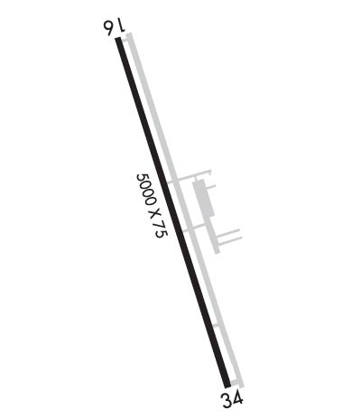
Runway Identifications
Runway Identification: 16/34Length: 5000 ft
Width: 75 ft
Surface: ASPHALT-GOOD CONDITION
Edge lights: Medium IntensityTreatment: NONE
| | Runway: 16 | | Runway: 34 |
| Mag heading: | 156° | Mag heading: | 336° |
| Rwy Slope: | .33% Up | Rwy Slope: | -.33% Down |
| Approach: | | Approach: | |
| Pattern: | Left Traffic | Pattern: | Left Traffic |
| Markings: | NONPRECISION INSTRUMENT | Markings: | NONPRECISION INSTRUMENT |
| Marking Condition: | GOOD | Marking Condition: | GOOD |
| Arresting Dev: | | Arresting Dev: | |
| Lat & Long: | N2954.9 W09657.1 | Lat. & Long.: | N2954.1 W09656.9 |
| Elev: | 307.7 ft. MSL | Elev: | 324.0 ft. MSL |
| TCH: | 42 ft. AGL | TCH: | 31 ft. AGL |
| Visual Glide Path: | 3.00 degrees | Visual Glide Path: | 3.00 degrees |
| Displaced Threshold: | No | Displaced Threshold: | No |
| Touchdown Zone: | YES | Touchdown Zone: | YES |
| Touchdown Elev.: | 318.4 feet | Touchdown Elev.: | 324.0 feet |
| Visual Glide Slope: | 2-Light PAPI on LEFT side of Runway | Visual Glide Slope: | 2-Light PAPI on LEFT side of Runway |
| RVR Equipment: | | RVR Equipment: | |
| RVV Equipment: | NO | RVV Equipment: | NO |
| Approach Lights: | | Approach Lights: | |
| REIL: | YES | REIL: | YES |
| Centerline Lights: | NO | Centerline Lights: | NO |
| Touchdown lights: | NO | Touchdown lights: | NO |
| Runway Category: | Runway with a Non-precision Approach having visibility minimums greater than 3/4 mile | Runway Category: | Runway with a Non-precision Approach having visibility minimums greater than 3/4 mile |
| Declared Distances: | | Declared Distances: | |
| Obstructions: | TREE | Obstructions: | TREE |
| Marked: | NOT Marked/Lighted | Marked: | NOT Marked/Lighted |
| Clearance slope: | 35:1 | Clearance slope: | 21:1 |
| Obstruction height: | 65 feet AGL | Obstruction height: | 60 feet AGL |
| Dist. from runway: | 2525 feet | Dist. from runway: | 1460 feet |
| Centerline offset: | | Centerline offset: | 140 feet right of centerline |
| Comments: | | Comments: | |

