Approach Charts
| FltPlan does not have IFR approach charts available for K3RC. |
Current Weather/Notams (Metars, TAFs, Notams, NWS Forecast, PIREPS, and nearby weather)
Customs Information Send updates to Support@FltPlan.com
Customs Not Available
Database effective 05/16/2024
Airport Diagram might not be current.
|
| Facility Name: | ROSCOMMON CONSERVATION |
| City Name: | ROSCOMMON |
| County: | ROSCOMMON |
| State abbrev: | MI |
| State Name: | MICHIGAN |
| | |
| Ownership: | PUBLICLY OWNED |
| Use: | OPEN TO THE PUBLIC |
| Owner's Name: | MI DEPT OF NATURAL RESOURCES |
| Address: | 8717 N ROSCOMMON RD |
| | ROSCOMMON, MI 48653-9207 |
| Owner's Phone: | 989-275-5151; EXTN 2722053. |
| | |
| Manager's Name: | KEVIN JACOBS |
| Address: | 8717 N ROSCOMMON RD |
| | ROSCOMMON, MI 48653-9207 |
| Phone: | 989-275-1150; EXTN 2051 FOR OFC. |
| | |
| FAA Region: | GREAT LAKES |
| FAA Field Office: | DET |
Runway Identifications
Runway Identification: 01/19Length: 2500 ft
Width: 100 ft
Surface: GRASS-POOR CONDITION
Edge lights: Treatment: NONE
| | Runway: 01 | | Runway: 19 |
| Mag heading: | 5° | Mag heading: | 185° |
| Rwy Slope: | -.24% Down | Rwy Slope: | .24% Up |
| Approach: | | Approach: | |
| Pattern: | Left Traffic | Pattern: | Left Traffic |
| Markings: | | Markings: | |
| Marking Condition: | 3 FT YELLOW CONES. | Marking Condition: | 3 FT YELLOW CONES. |
| Arresting Dev: | | Arresting Dev: | |
| Lat & Long: | N4428.2 W08433.8 | Lat. & Long.: | N4428.7 W08433.8 |
| Elev: | 1157.0 ft. MSL | Elev: | 1151.0 ft. MSL |
| TCH: | | TCH: | |
| Visual Glide Path: | | Visual Glide Path: | |
| Displaced Threshold: | 770 feet | Displaced Threshold: | 100 feet |
| Touchdown Zone: | YES | Touchdown Zone: | YES |
| Touchdown Elev.: | 1157.0 feet | Touchdown Elev.: | 1157.0 feet |
| Visual Glide Slope: | | Visual Glide Slope: | |
| RVR Equipment: | | RVR Equipment: | |
| RVV Equipment: | NO | RVV Equipment: | NO |
| Approach Lights: | | Approach Lights: | |
| REIL: | NO | REIL: | NO |
| Centerline Lights: | NO | Centerline Lights: | NO |
| Touchdown lights: | NO | Touchdown lights: | NO |
| Runway Category: | Runway with a Visual Approach | Runway Category: | Runway with a Visual Approach |
| Declared Distances: | | Declared Distances: | |
| Obstructions: | TREES | Obstructions: | TREES |
| Marked: | NOT Marked/Lighted | Marked: | NOT Marked/Lighted |
| Clearance slope: | 7:1; APCH RATIO 8:1 TO DTHR OVR +10 FT TREE, 86 FT DIST, 80 FT L. | Clearance slope: | 18:1; APCH RATIO 20:1 TO DTHR. |
| Obstruction height: | 61 feet AGL | Obstruction height: | 56 feet AGL |
| Dist. from runway: | 469 feet | Dist. from runway: | 1029 feet |
| Centerline offset: | 125 right of centerline | Centerline offset: | 30 feet right of centerline |
| Comments: | | Comments: | |
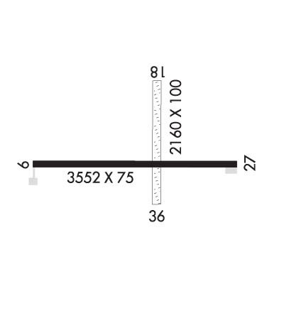
Runway Identification: 10/28Length: 3552 ft
Width: 75 ft
Surface: ASPHALT
Edge lights: Low IntensityTreatment: NONE
| | Runway: 10 | | Runway: 28 |
| Mag heading: | 94° | Mag heading: | 274° |
| Rwy Slope: | -.06% Down | Rwy Slope: | .06% Up |
| Approach: | | Approach: | |
| Pattern: | Left Traffic | Pattern: | Left Traffic |
| Markings: | BASIC | Markings: | BASIC |
| Marking Condition: | GOOD | Marking Condition: | GOOD |
| Arresting Dev: | | Arresting Dev: | |
| Lat & Long: | N4428.4 W08434.3 | Lat. & Long.: | N4428.4 W08433.5 |
| Elev: | 1152.0 ft. MSL | Elev: | 1150.0 ft. MSL |
| TCH: | | TCH: | |
| Visual Glide Path: | | Visual Glide Path: | |
| Displaced Threshold: | 150 feet | Displaced Threshold: | No |
| Touchdown Zone: | YES | Touchdown Zone: | YES |
| Touchdown Elev.: | 1156.0 feet | Touchdown Elev.: | 1156.0 feet |
| Visual Glide Slope: | | Visual Glide Slope: | |
| RVR Equipment: | | RVR Equipment: | |
| RVV Equipment: | NO | RVV Equipment: | NO |
| Approach Lights: | | Approach Lights: | |
| REIL: | NO | REIL: | NO |
| Centerline Lights: | NO | Centerline Lights: | NO |
| Touchdown lights: | NO | Touchdown lights: | NO |
| Runway Category: | Runway with a Visual Approach | Runway Category: | Runway with a Visual Approach |
| Declared Distances: | | Declared Distances: | |
| Obstructions: | TREES | Obstructions: | |
| Marked: | NOT Marked/Lighted | Marked: | |
| Clearance slope: | 1:1; APCH RATIO 20:1 TO DTHR. | Clearance slope: | 20:1 |
| Obstruction height: | 30 feet AGL | Obstruction height: | |
| Dist. from runway: | 245 feet | Dist. from runway: | |
| Centerline offset: | 115 left of centerline | Centerline offset: | |
| Comments: | 15 FT ROAD, 145 FT DIST; 25 FT TREES, 178 FT DIST; 4 FT FENCE, 85 FT DIST. | Comments: | |

