Approach Charts
| FltPlan does not have IFR approach charts available for K3O9. |
Current Weather/Notams (Metars, TAFs, Notams, NWS Forecast, PIREPS, and nearby weather)
Customs Information Send updates to Support@FltPlan.com
Customs Not Available
Database effective 05/16/2024
Airport Diagram might not be current.
|
| Facility Name: | GRAND LAKE RGNL |
| City Name: | AFTON |
| County: | DELAWARE |
| State abbrev: | OK |
| State Name: | OKLAHOMA |
| | |
| Ownership: | PRIVATELY OWNED |
| Use: | OPEN TO THE PUBLIC |
| Owner's Name: | WINGS TO WATER LLC |
| Address: | 56351 E. HWY 125 |
| | MONKEY ISLAND, OK 74331 |
| Owner's Phone: | 573-569-4448 |
| | |
| Manager's Name: | TODD LARAMORE |
| Address: | 56351 E. HWY 125 |
| | MONKEY ISLAND, OK 74331 |
| Phone: | 573-569-4448 |
| | |
| FAA Region: | SOUTHWEST |
| FAA Field Office: | AOK |
Runway Identifications
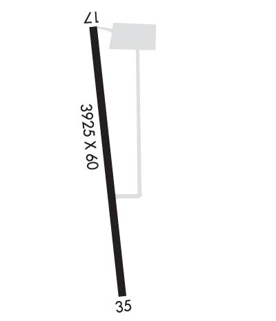
Runway Identification: 17/35Length: 3925 ft
Width: 60 ft
Surface: CONCRETE-FAIR CONDITION
Edge lights: Medium IntensityTreatment: NONE
| | Runway: 17 | | Runway: 35 |
| Mag heading: | 166° | Mag heading: | 346° |
| Approach: | | Approach: | |
| Pattern: | Left Traffic | Pattern: | Left Traffic |
| Markings: | BASIC | Markings: | BASIC |
| Marking Condition: | FAIR | Marking Condition: | FAIR |
| Arresting Dev: | | Arresting Dev: | |
| Lat & Long: | | Lat. & Long.: | |
| Elev: | N/A | Elev: | N/A |
| TCH: | 35 ft. AGL | TCH: | 29 ft. AGL |
| Visual Glide Path: | 4.25 degrees | Visual Glide Path: | 3.75 degrees |
| Displaced Threshold: | 230 feet | Displaced Threshold: | 230 feet |
| Touchdown Zone: | YES | Touchdown Zone: | NO |
| Touchdown Elev.: | 792.0 feet | Touchdown Elev.: | |
| Visual Glide Slope: | 2-Box VASI on LEFT side of Runway | Visual Glide Slope: | 2-Box VASI on LEFT side of Runway; VASI OTS INDEFLY. |
| RVR Equipment: | | RVR Equipment: | |
| RVV Equipment: | NO | RVV Equipment: | NO |
| Approach Lights: | | Approach Lights: | |
| REIL: | YES; REIL OTS INDEFLY. | REIL: | NO |
| Centerline Lights: | NO | Centerline Lights: | NO |
| Touchdown lights: | NO | Touchdown lights: | NO |
| Runway Category: | Runway with a Visual Approach | Runway Category: | Runway with a Visual Approach |
| Declared Distances: | | Declared Distances: | |
| Obstructions: | TREES | Obstructions: | |
| Marked: | NOT Marked/Lighted | Marked: | |
| Clearance slope: | 1:1 | Clearance slope: | 20:1 |
| Obstruction height: | 30 feet AGL | Obstruction height: | |
| Dist. from runway: | 200 feet | Dist. from runway: | |
| Centerline offset: | 185 right of centerline | Centerline offset: | |
| Comments: | +40 FT TREES 97 FT R AT THLD; +7 FT ROAD 40 FT FM RY END & 0B. | Comments: | +10 FT MARINA BUILDING 60 FT FM RY END & 190 FT R. |
