Click here for more info on on SMS!

K3N6

OLD BRIDGE
OLD BRIDGE
NJ
Time Zone: Eastern
Lat: N 4019.8
Long: W 07420.8
Elev: 87
Var: +13
Longest Runway: 3594
CTAF: 123.07

FBO & Flight Services info for K3N6

FBOs: Update your Fuel Prices
Providing high quality fuel and services to you and your customers, from Phillips 66 Aviation.
Ph: 732-446-0303
-
Freq: 122.8Website-
Service
Jet
100LL
SAF
MoGas
Full        Caution: Fuel prices have not been updated in 47 days.
Last Update: 03/10/2024 11:47

DISCOUNT W/PHILLIPS CREDIT CARD
Self  6.40    
Misc. Info: Address: 182 PENSION RD   ENGLISHTOWN, NJ 07726

If you are an FBO, call 1-203-262-1700 to update your info or email: FltPlan.Advertising@garmin.com
Advertise your FBO on FltPlan.com

Runway & Approach Info for K3N6
Rwy
Length
Land Dist**
Approach*
  Rwy
Length
Land Dist**
Approach*
06
3594x50  2994'          
 
  
24
  3594x50  3194'          
 
 * only ILS, LOC, LDA, and SDF approaches to a specific runway are shown
** For any Declared Landing Distance Available, please see A/FD or Approach plates
Runway Weight Capability (lbs.) Help
Runway IDSingle WheelDouble WheelDouble Tandem WheelDual Double Wheel
06/24N/AN/AN/AN/A
These numbers are Advisory and are not limits.   The Airport Manager should have more accurate Weight Limits
Approach Charts
Approaches    
Current Weather/Notams
Customs Information Send updates to Support@FltPlan.com
Customs Not Available
Database effective 05/16/2024
Airport Diagram of K3N6
Airport Diagram might not be current.

Facility Name: OLD BRIDGE
City Name: OLD BRIDGE
County: MIDDLESEX
State abbrev: NJ
State Name: NEW JERSEY
   
Ownership: PRIVATELY OWNED
Use: OPEN TO THE PUBLIC
Owner's Name: MADISON INC.
Address: 182 PENSION RD
 ENGLISHTOWN, NJ 07726
Owner's Phone: 732-446-0303
  
Manager's Name: PAUL CERNIGLIA
Address: 182 PENSION RD
 ENGLISHTOWN, NJ 07726
Phone: 732-718-0444
   
FAA Region: EASTERN
FAA Field Office: HAR
September 2007 - Photo courtesy of Gary Bronne


Click here for full scale & interactive Sectional view of K3N6


Sunrise / Sunset times for OLD BRIDGE

DateSunriseSunset
04/25/24 Thursday6:0419:47
04/26/24 Friday6:0219:48
04/27/24 Saturday6:0119:49
04/28/24 Sunday6:0019:50
04/29/24 Monday5:5819:51
04/30/24 Tuesday5:5719:53
05/01/24 Wednesday5:5619:54
05/02/24 Thursday5:5519:55
05/03/24 Friday5:5319:56
05/04/24 Saturday5:5219:57
05/05/24 Sunday5:5119:58
05/06/24 Monday5:5019:59
05/07/24 Tuesday5:4920:00
05/08/24 Wednesday5:4820:01

Airport Facilities

Airport Attendance Schedule7 Days A Week 0800-1700
Airport Status OPERATIONAL (This Status can change at any time - please check NOTAMS)
Airport Lighting ScheduleACTVT REIL RWY 6 & 24; MIRL RWY 06/24 - CTAF.; ACTVT ROTG BCN - CTAF.
Airport Storage AvailableTie Downs
Extra Services AvailableFlight Instruction, Aircraft Rental
Wind IndicatorYES - (lighted)
Control TowerNO
CTAF Frequency123.075
Unicom Frequency123.075
Rotating Beacon ColorWG
Segmented CircleYES
Landing Fee

Airport Inspection Data

Airport InspectedSTATE - performed by STATE AERONAUTICAL PERSONNEL
Inspection Date05/17/2023

Airport Services

Type of Fuel AvailableGrade 100LL
Airframe Repair ServiceMAJOR
Power Plant Repair ServiceMAJOR

Geographic Data

LatitudeN4019.8
LongitudeW07420.8 (ESTIMATED)
Arpt Elevation87ft (ESTIMATED)
Magnetic Variation13W
5 miles Sof OLD BRIDGE
Traffic Pattern Altitude
Sectional ChartNEW YORK

Aircraft Data

Operations (Reported)YearlyAvg. Daily
General Aviation Transient 515014
General Aviation Local 1255034
Air Taxi 00
Commerical 00
Commuter 00
Military 00
Aircraft based on Field
General Aviation Singles 90
General Aviation Multi 4
Jet Aircraft 0
General Aviation Helicopters 1
Military Aircraft 0
Gliders 0
Ultralights 0

FAA Services

FSS on field NO
FSS tie-in MILLVILLE
FSS Phone 1-800-WX-BRIEF
Who issues Notams MIV
Notam D service at airport YES
ARTCC Name NEW YORK

Federal Status

Airport Certification
Aircraft Rescue & Firefighting IndexNone
Airport of EntryNo
Custom Landing RightsNo
Joint Civil/MilitaryNo
Military Landing rightsNo

Remarks

THIS AIRPORT HAS BEEN SURVEYED BY THE NATIONAL GEODETIC SURVEY.
NO TOUCH & GO.
GCO AVBL ON FREQ 121.725 THRU MIV RADIO.
DRAG STRIP PARK & TREES E/W OF ARPT & INVOF APCH END RWY 6/24.
FOR CD USE GCO 121.725, IF UNABLE CTC MC GUIRE APCH AT 609-754-2767.
DEER & BIRDS ON & INVOF ARPT.
TWYS FAIR COND, 2 IN CRACKS, 2 TO 3 IN DEEP, NEAR TWY HOLD SHORT LINES. TWY SFCS UNEVEN. ALL TWY MKGS FADED.
Airport Communications & Frequencies:
CTAF Frequency:
123.075
Unicom Frequency:
123.075
MC GUIRE Primary Approach Frequencies:  
126.475
363.8
MC GUIRE Primary Departure Frequencies:  
126.475
363.8
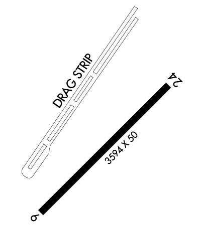
Runway Identifications
Runway Identification: 06/24
Length: 3594 ft
Width: 50 ft
Surface: ASPHALT-FAIR CONDITION
Edge lights: Medium Intensity

Treatment: NONE

 Runway: 06   Runway: 24
Mag heading: 57°Mag heading: 237°
Rwy Slope: .64% UpRwy Slope: -.64% Down
Approach: Approach:
Pattern: Left TrafficPattern: Right Traffic
Markings: NONPRECISION INSTRUMENTMarkings: NONPRECISION INSTRUMENT
Marking Condition: FAIRMarking Condition: FAIR
Arresting Dev: Arresting Dev:
Lat & Long: N4019.6  W07421.1Lat. & Long.: N4020.0  W07420.5
Elev: 63.0 ft. MSLElev: 86.0 ft. MSL
TCH: 25 ft. AGLTCH: 40 ft. AGL
Visual Glide Path: 4.00 degreesVisual Glide Path: 4.00 degrees
Displaced Threshold: 600 feetDisplaced Threshold: 400 feet
Touchdown Zone: YESTouchdown Zone: YES
Touchdown Elev.: 87.0 feetTouchdown Elev.: 87.0 feet
Visual Glide Slope: 2-Light PAPI on LEFT side of RunwayVisual Glide Slope: 2-Light PAPI on RIGHT side of Runway
RVR Equipment: RVR Equipment:
RVV Equipment: NORVV Equipment: NO
Approach Lights: Approach Lights:
REIL: YESREIL: YES
Centerline Lights: NOCenterline Lights: NO
Touchdown lights: NOTouchdown lights: NO
Runway Category: Runway with a Visual ApproachRunway Category: Runway with a Non-precision Approach
Declared Distances: Declared Distances:
Obstructions: TREEObstructions: TREE
Marked: NOT Marked/LightedMarked: NOT Marked/Lighted
Clearance slope: 1:1; APCH SLOPE 11:1 TO DSPLCD THLD.Clearance slope: 5:1; APCH SLOPE 20:1 TO DSPLCD THLD.
Obstruction height: 80 feet AGLObstruction height: 40 feet AGL
Dist. from runway: 280 feetDist. from runway: 400 feet
Centerline offset: 200 right of centerlineCenterline offset: 135 feet left of centerline
Comments: 16 FT HNGR 53 FT FROM RWY END 200 FT L OF CNTRLN; 25 FT TREELINE 125 FT FROM RWY END ACRS CNTRLN.Comments:
C:1/P: