Current Weather/Notams (Metars, TAFs, Notams, NWS Forecast, PIREPS, and nearby weather)
Customs Information Send updates to Support@FltPlan.com
Customs Not Available
Database effective 05/16/2024
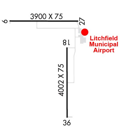
Airport Diagram might not be current. Facility Name: LITCHFIELD MUNI City Name: LITCHFIELD County: MONTGOMERY State abbrev: IL State Name: ILLINOIS Ownership: PUBLICLY OWNED Use: OPEN TO THE PUBLIC Owner's Name: LITCHFIELD ARPT AUTH; BILL FLEMING, CHAIRMAN. Address: 1201 US ROUTE 66 SOUTH, P.O. BOX 381 LITCHFIELD, IL 62056 Owner's Phone: 217-324-6507 Manager's Name: NICHOLAS WEATHERFORD Address: 1201US ROUTE 66 SOUTH, P.O. BOX 381; EMAIL ADDRESS: AIRPORT@LITCHFIELDIL.COM (ALL LOWER CASE) LITCHFIELD, IL 62056 Phone: 217-556-4299 FAA Region: GREAT LAKES FAA Field Office: CHI
Runway Identifications Help
Runway Identification: 09/27 Length: 3900 ftWidth: 75 ftSurface: ASPHALT-GOOD CONDITIONEdge lights: Medium Intensity Treatment: NONE Runway: 09 Runway: 27 Mag heading: 89° Mag heading: 269° Rwy Slope: .21% Up Rwy Slope: -.21% Down Approach: Approach: Pattern: Right Traffic Pattern: Left Traffic Markings: NONPRECISION INSTRUMENT Markings: NONPRECISION INSTRUMENT Marking Condition: GOOD Marking Condition: GOOD Arresting Dev: Arresting Dev: Lat & Long: N3910.0 W08941.0 Lat. & Long.: N3910.0 W08940.2 Elev: 681.9 ft. MSL Elev: 689.9 ft. MSL TCH: 25 ft. AGL TCH: 24 ft. AGL Visual Glide Path: 3.00 degrees Visual Glide Path: 3.00 degrees Displaced Threshold: No Displaced Threshold: No Touchdown Zone: YES Touchdown Zone: YES Touchdown Elev.: 689.4 feet Touchdown Elev.: 690.5 feet Visual Glide Slope: 2-Light PAPI on LEFT side of Runway Visual Glide Slope: 2-Light PAPI on LEFT side of Runway RVR Equipment: RVR Equipment: RVV Equipment: NO RVV Equipment: NO Approach Lights: Approach Lights: REIL: YES REIL: YES Centerline Lights: NO Centerline Lights: NO Touchdown lights: NO Touchdown lights: NO Runway Category: Runway with a Non-precision Approach Runway Category: Runway with a Non-precision Approach Declared Distances: Declared Distances: Obstructions: ROAD Obstructions: Marked: NOT Marked/Lighted Marked: Clearance slope: 18:1; APCH RATIO 33:1 TO RY END FM OVER C.O. Clearance slope: 20:1 Obstruction height: 14 feet AGL Obstruction height: Dist. from runway: 464 feet Dist. from runway: Centerline offset: 289 left of centerline Centerline offset: Comments: Comments:
Runway Identification: 18/36 Length: 4002 ftWidth: 75 ftSurface: ASPHALT-GOOD CONDITIONEdge lights: Medium Intensity Treatment: NONE Runway: 18 Runway: 36 Mag heading: 178° Mag heading: 358° Rwy Slope: -.13% Down Rwy Slope: .13% Up Approach: Approach: Pattern: Right Traffic Pattern: Left Traffic Markings: NONPRECISION INSTRUMENT Markings: NONPRECISION INSTRUMENT Marking Condition: FAIR Marking Condition: FAIR Arresting Dev: Arresting Dev: Lat & Long: N3909.8 W08940.3 Lat. & Long.: N3909.1 W08940.3 Elev: 685.3 ft. MSL Elev: 680.0 ft. MSL TCH: 23 ft. AGL TCH: 25 ft. AGL Visual Glide Path: 3.00 degrees Visual Glide Path: 3.00 degrees Displaced Threshold: No Displaced Threshold: No Touchdown Zone: YES Touchdown Zone: YES Touchdown Elev.: 685.5 feet Touchdown Elev.: 682.2 feet Visual Glide Slope: 2-Light PAPI on LEFT side of Runway Visual Glide Slope: 2-Light PAPI on LEFT side of Runway RVR Equipment: RVR Equipment: RVV Equipment: NO RVV Equipment: NO Approach Lights: Approach Lights: REIL: YES REIL: YES Centerline Lights: NO Centerline Lights: NO Touchdown lights: NO Touchdown lights: NO Runway Category: Runway with a Non-precision Approach having visibility minimums greater than 3/4 mile Runway Category: Runway with a Non-precision Approach having visibility minimums greater than 3/4 mile Declared Distances: Declared Distances: