Current Weather/Notams (Metars, TAFs, Notams, NWS Forecast, PIREPS, and nearby weather)
Customs Information Send updates to Support@FltPlan.com
Customs Not Available
Database effective 05/16/2024
Airport Diagram might not be current.
|
| Facility Name: | SYRACUSE-HAMILTON COUNTY MUNI |
| City Name: | SYRACUSE |
| County: | HAMILTON |
| State abbrev: | KS |
| State Name: | KANSAS |
| | |
| Ownership: | PUBLICLY OWNED |
| Use: | OPEN TO THE PUBLIC |
| Owner's Name: | CITY OF SYRACUSE/HAMILTON CO |
| Address: | BOX 1136 |
| | SYRACUSE, KS 67878 |
| Owner's Phone: | 620-384-5629 |
| | |
| Manager's Name: | STEVE PHILLIPS |
| Address: | BOX 1136 |
| | SYRACUSE, KS 67878 |
| Phone: | 620-384-5468 |
| | |
| FAA Region: | CENTRAL |
| FAA Field Office: | NONE |
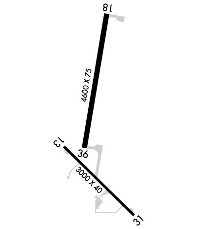
Runway Identifications
Runway Identification: 13/31Length: 3000 ft
Width: 40 ft
Surface: ASPHALT-GOOD CONDITION
Edge lights: Medium IntensityTreatment: NONE
Weight: PCN 5 /F/C/Y/U
| | Runway: 13 | | Runway: 31 |
| Mag heading: | 128° | Mag heading: | 308° |
| Rwy Slope: | -.31% Down | Rwy Slope: | .31% Up |
| Approach: | | Approach: | |
| Pattern: | Left Traffic | Pattern: | Right Traffic |
| Markings: | BASIC | Markings: | BASIC |
| Marking Condition: | FAIR | Marking Condition: | FAIR |
| Arresting Dev: | | Arresting Dev: | |
| Lat & Long: | N3759.8 W10145.1 | Lat. & Long.: | N3759.4 W10144.6 |
| Elev: | 3312.2 ft. MSL | Elev: | 3303.0 ft. MSL |
| TCH: | | TCH: | |
| Visual Glide Path: | | Visual Glide Path: | |
| Displaced Threshold: | No | Displaced Threshold: | 355 feet |
| Touchdown Zone: | YES | Touchdown Zone: | YES |
| Touchdown Elev.: | 3312.2 feet | Touchdown Elev.: | 3312.2 feet |
| Visual Glide Slope: | | Visual Glide Slope: | |
| RVR Equipment: | | RVR Equipment: | |
| RVV Equipment: | NO | RVV Equipment: | NO |
| Approach Lights: | | Approach Lights: | |
| REIL: | NO | REIL: | NO |
| Centerline Lights: | NO | Centerline Lights: | NO |
| Touchdown lights: | NO | Touchdown lights: | NO |
| Runway Category: | Runway with a Visual Approach | Runway Category: | Runway with a Visual Approach |
| Declared Distances: | | Declared Distances: | |
| Obstructions: | ROAD | Obstructions: | TREE |
| Marked: | NOT Marked/Lighted | Marked: | NOT Marked/Lighted |
| Clearance slope: | 1:1 | Clearance slope: | 6:1; APCH RATIO FM DSPLCD THR 37.1 |
| Obstruction height: | 15 feet AGL | Obstruction height: | 26 feet AGL |
| Dist. from runway: | 220 feet | Dist. from runway: | 373 feet |
| Centerline offset: | | Centerline offset: | 171 feet left of centerline |
| Comments: | | Comments: | +15 ROAD 125 FT R; 115 FT FRM RWY 31 END. |
Runway Identification: 18/36Length: 4600 ft
Width: 75 ft
Surface: CONCRETE-GOOD CONDITION
Edge lights: Medium IntensityTreatment: NONE
Weight: PCN 11 /R/C/X/U
| | Runway: 18 | | Runway: 36 |
| Mag heading: | 183° | Mag heading: | 3° |
| Rwy Slope: | -.24% Down | Rwy Slope: | .24% Up |
| Approach: | | Approach: | |
| Pattern: | Right Traffic | Pattern: | Left Traffic |
| Markings: | NONPRECISION INSTRUMENT | Markings: | NONPRECISION INSTRUMENT |
| Marking Condition: | GOOD | Marking Condition: | GOOD |
| Arresting Dev: | | Arresting Dev: | |
| Lat & Long: | N3800.5 W10144.8 | Lat. & Long.: | N3759.7 W10144.9 |
| Elev: | 3326.1 ft. MSL | Elev: | 3314.9 ft. MSL |
| TCH: | 35 ft. AGL | TCH: | 44 ft. AGL |
| Visual Glide Path: | 3.00 degrees | Visual Glide Path: | 3.20 degrees |
| Displaced Threshold: | No | Displaced Threshold: | No |
| Touchdown Zone: | YES | Touchdown Zone: | YES |
| Touchdown Elev.: | 3326.1 feet | Touchdown Elev.: | 3317.5 feet |
| Visual Glide Slope: | 4-Light PAPI on RIGHT side of Runway | Visual Glide Slope: | 4-Light PAPI on LEFT side of Runway |
| RVR Equipment: | | RVR Equipment: | |
| RVV Equipment: | NO | RVV Equipment: | NO |
| Approach Lights: | | Approach Lights: | |
| REIL: | NO | REIL: | NO |
| Centerline Lights: | NO | Centerline Lights: | NO |
| Touchdown lights: | NO | Touchdown lights: | NO |
| Runway Category: | Runway with a Non-precision Approach having visibility minimums greater than 3/4 mile | Runway Category: | Runway with a Non-precision Approach having visibility minimums greater than 3/4 mile |
| Declared Distances: | | Declared Distances: | |
| Obstructions: | PLINE | Obstructions: | BLDG |
| Marked: | MARKED | Marked: | MARKED and LIGHTED |
| Clearance slope: | 20:1 | Clearance slope: | 9:1 |
| Obstruction height: | 55 feet AGL | Obstruction height: | 25 feet AGL |
| Dist. from runway: | 1327 feet | Dist. from runway: | 426 feet |
| Centerline offset: | | Centerline offset: | 395 feet left of centerline |
| Comments: | | Comments: | |
