Current Weather/Notams (Metars, TAFs, Notams, NWS Forecast, PIREPS, and nearby weather)
Customs Information Send updates to Support@FltPlan.com
Customs Not Available
Database effective 05/16/2024
Airport Diagram might not be current.
|
| Facility Name: | FREEMAN FLD |
| City Name: | JUNCTION CITY |
| County: | GEARY |
| State abbrev: | KS |
| State Name: | KANSAS |
| | |
| Ownership: | PUBLICLY OWNED |
| Use: | OPEN TO THE PUBLIC |
| Owner's Name: | CITY OF JUNCTION CITY |
| Address: | PO BOX 287 |
| | JUNCTION CITY, KS 66441 |
| Owner's Phone: | 785-238-3103 |
| | |
| Manager's Name: | MARVIN HORNBOSTEL; FBO PHONE (785) 761-7692 |
| Address: | RAVEN AREO SERVICES |
| | JUNCTION CITY, KS 66441 |
| Phone: | (785) 761-7692 |
| | |
| FAA Region: | CENTRAL |
| FAA Field Office: | NONE |
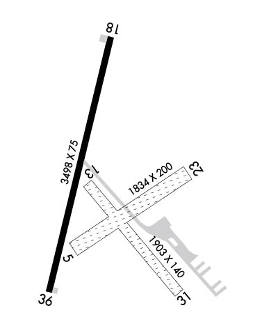
Runway Identifications
Runway Identification: 05/23Length: 1834 ft
Width: 200 ft
Surface: GRASS-GOOD CONDITION
Edge lights: Treatment: NONE
| | Runway: 05 | | Runway: 23 |
| Mag heading: | 52° | Mag heading: | 232° |
| Rwy Slope: | -.51% Down | Rwy Slope: | .51% Up |
| Approach: | | Approach: | |
| Pattern: | Left Traffic | Pattern: | Left Traffic |
| Markings: | | Markings: | |
| Marking Condition: | APCH END RWY 05/23 MKD WITH BLUE & WHITE PLASTIC BARRELS. | Marking Condition: | |
| Arresting Dev: | | Arresting Dev: | |
| Lat & Long: | N3902.5 W09650.7 | Lat. & Long.: | N3902.7 W09650.4 |
| Elev: | 1097.4 ft. MSL | Elev: | 1088.1 ft. MSL |
| TCH: | | TCH: | |
| Visual Glide Path: | | Visual Glide Path: | |
| Displaced Threshold: | No | Displaced Threshold: | No |
| Touchdown Zone: | YES | Touchdown Zone: | YES |
| Touchdown Elev.: | 1097.4 feet | Touchdown Elev.: | 1097.4 feet |
| Visual Glide Slope: | | Visual Glide Slope: | |
| RVR Equipment: | | RVR Equipment: | |
| RVV Equipment: | NO | RVV Equipment: | NO |
| Approach Lights: | | Approach Lights: | |
| REIL: | NO | REIL: | NO |
| Centerline Lights: | NO | Centerline Lights: | NO |
| Touchdown lights: | NO | Touchdown lights: | NO |
| Runway Category: | Runway with a Visual Approach | Runway Category: | Runway with a Visual Approach |
| Declared Distances: | | Declared Distances: | |
| Obstructions: | TREES | Obstructions: | POLE |
| Marked: | NOT Marked/Lighted | Marked: | NOT Marked/Lighted |
| Clearance slope: | 1:1 | Clearance slope: | 11:1 |
| Obstruction height: | 18 feet AGL | Obstruction height: | 33 feet AGL |
| Dist. from runway: | 32 feet | Dist. from runway: | 392 feet |
| Centerline offset: | 225 right of centerline | Centerline offset: | 91 feet left of centerline |
| Comments: | | Comments: | |
Runway Identification: 13/31Length: 1903 ft
Width: 140 ft
Surface: GRASS-GOOD CONDITION
Edge lights: Treatment: NONE
| | Runway: 13 | | Runway: 31 |
| Mag heading: | 135° | Mag heading: | 315° |
| Rwy Slope: | .03% Up | Rwy Slope: | -.03% Down |
| Approach: | | Approach: | |
| Pattern: | Left Traffic | Pattern: | Left Traffic |
| Markings: | | Markings: | |
| Marking Condition: | APCH END OF RWY 13 IS DELINEATED WITH BLUE & WHITE PLASTIC BARRELS. | Marking Condition: | RWY 31 APCH END RWY 31 IS DELINEATED WITH BLUE & WHITE BARRELS & YELLOW PAINTED TIRES. |
| Arresting Dev: | | Arresting Dev: | |
| Lat & Long: | N3902.6 W09650.7 | Lat. & Long.: | N3902.4 W09650.4 |
| Elev: | 1093.5 ft. MSL | Elev: | 1094.1 ft. MSL |
| TCH: | | TCH: | |
| Visual Glide Path: | | Visual Glide Path: | |
| Displaced Threshold: | No | Displaced Threshold: | No |
| Touchdown Zone: | YES | Touchdown Zone: | YES |
| Touchdown Elev.: | 1094.1 feet | Touchdown Elev.: | 1094.1 feet |
| Visual Glide Slope: | | Visual Glide Slope: | |
| RVR Equipment: | | RVR Equipment: | |
| RVV Equipment: | NO | RVV Equipment: | NO |
| Approach Lights: | | Approach Lights: | |
| REIL: | NO | REIL: | NO |
| Centerline Lights: | NO | Centerline Lights: | NO |
| Touchdown lights: | NO | Touchdown lights: | NO |
| Runway Category: | Runway with a Visual Approach | Runway Category: | Runway with a Visual Approach |
| Declared Distances: | | Declared Distances: | |
| Obstructions: | TREES | Obstructions: | TREES |
| Marked: | NOT Marked/Lighted | Marked: | NOT Marked/Lighted |
| Clearance slope: | 16:1 | Clearance slope: | 1:1 |
| Obstruction height: | 18 feet AGL | Obstruction height: | 63 feet AGL |
| Dist. from runway: | 294 feet | Dist. from runway: | 79 feet |
| Centerline offset: | 10 left of centerline | Centerline offset: | 125 feet left of centerline |
| Comments: | | Comments: | |
Runway Identification: 18/36Length: 3498 ft
Width: 75 ft
Surface: ASPHALT-FAIR CONDITION
Edge lights: Medium IntensityTreatment: NONE
Weight: PCN 5 /F/C/Y/U
| | Runway: 18 | | Runway: 36 |
| Mag heading: | 189° | Mag heading: | 9° |
| Rwy Slope: | .44% Up | Rwy Slope: | -.44% Down |
| Approach: | | Approach: | |
| Pattern: | Left Traffic | Pattern: | Left Traffic |
| Markings: | BASIC | Markings: | NONPRECISION INSTRUMENT |
| Marking Condition: | FAIR | Marking Condition: | FAIR |
| Arresting Dev: | | Arresting Dev: | |
| Lat & Long: | N3902.9 W09650.6 | Lat. & Long.: | N3902.4 W09650.8 |
| Elev: | 1086.2 ft. MSL | Elev: | 1101.6 ft. MSL |
| TCH: | 43 ft. AGL | TCH: | 43 ft. AGL |
| Visual Glide Path: | 3.00 degrees | Visual Glide Path: | 3.50 degrees |
| Displaced Threshold: | No | Displaced Threshold: | No |
| Touchdown Zone: | YES | Touchdown Zone: | YES |
| Touchdown Elev.: | 1099.1 feet | Touchdown Elev.: | 1101.6 feet |
| Visual Glide Slope: | 2-Light PAPI on LEFT side of Runway | Visual Glide Slope: | 2-Light PAPI on LEFT side of Runway |
| RVR Equipment: | | RVR Equipment: | |
| RVV Equipment: | NO | RVV Equipment: | NO |
| Approach Lights: | | Approach Lights: | |
| REIL: | NO; RWY LGT KNOCKED OVR OFFSET R. | REIL: | NO |
| Centerline Lights: | NO | Centerline Lights: | NO |
| Touchdown lights: | NO | Touchdown lights: | NO |
| Runway Category: | Runway with a Visual Approach | Runway Category: | Runway with a Non-precision Approach |
| Declared Distances: | | Declared Distances: | |
| Obstructions: | POLE | Obstructions: | POLE |
| Marked: | LIGHTED | Marked: | LIGHTED |
| Clearance slope: | 6:1 | Clearance slope: | 7:1 |
| Obstruction height: | 35 feet AGL | Obstruction height: | 68 feet AGL |
| Dist. from runway: | 443 feet | Dist. from runway: | 684 feet |
| Centerline offset: | 258 right of centerline | Centerline offset: | 390 feet right of centerline |
| Comments: | | Comments: | |

