Current Weather/Notams (Metars, TAFs, Notams, NWS Forecast, PIREPS, and nearby weather)
Customs Information Send updates to Support@FltPlan.com
Customs Not Available
Database effective 05/16/2024
Airport Diagram might not be current.
|
| Facility Name: | SKY KING |
| City Name: | TERRE HAUTE |
| County: | VIGO |
| State abbrev: | IN |
| State Name: | INDIANA |
| | |
| Ownership: | PRIVATELY OWNED |
| Use: | OPEN TO THE PUBLIC |
| Owner's Name: | SKY KING ARPT INC. |
| Address: | 6898 N. CLINTON ST |
| | TERRE HAUTE, IN 47805 |
| Owner's Phone: | 812-466-2229 |
| | |
| Manager's Name: | STEVE BROWN |
| Address: | 6898 N. CLINTON ST |
| | TERRE HAUTE, IN 47805 |
| Phone: | 812-466-2229 |
| | |
| FAA Region: | GREAT LAKES |
| FAA Field Office: | CHI |
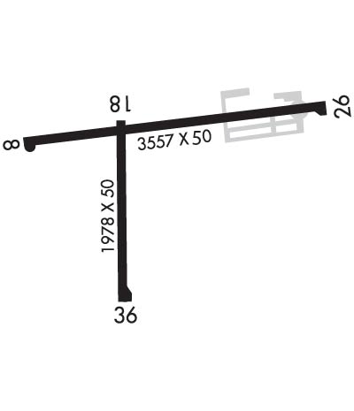
Runway Identifications
Runway Identification: 09/27Length: 3557 ft
Width: 50 ft
Surface: ASPHALT-FAIR CONDITION
Edge lights: Low IntensityTreatment: NONE
| | Runway: 09 | | Runway: 27 |
| Mag heading: | 88° | Mag heading: | 268° |
| Rwy Slope: | .08% Up | Rwy Slope: | -.08% Down |
| Approach: | | Approach: | |
| Pattern: | Left Traffic | Pattern: | Left Traffic |
| Markings: | BASIC | Markings: | BASIC |
| Marking Condition: | GOOD | Marking Condition: | GOOD |
| Arresting Dev: | | Arresting Dev: | |
| Lat & Long: | N3932.9 W08723.0 | Lat. & Long.: | N3933.0 W08722.2 |
| Elev: | 493.0 ft. MSL | Elev: | 496.0 ft. MSL |
| TCH: | | TCH: | |
| Visual Glide Path: | | Visual Glide Path: | |
| Displaced Threshold: | No | Displaced Threshold: | 812 feet |
| Touchdown Zone: | NO | Touchdown Zone: | NO |
| Touchdown Elev.: | | Touchdown Elev.: | |
| Visual Glide Slope: | | Visual Glide Slope: | |
| RVR Equipment: | | RVR Equipment: | |
| RVV Equipment: | NO | RVV Equipment: | NO |
| Approach Lights: | | Approach Lights: | |
| REIL: | NO | REIL: | NO |
| Centerline Lights: | NO | Centerline Lights: | NO |
| Touchdown lights: | NO | Touchdown lights: | NO |
| Runway Category: | Runway with a Visual Approach | Runway Category: | Runway with a Visual Approach |
| Declared Distances: | | Declared Distances: | |
| Obstructions: | TREES | Obstructions: | TREES |
| Marked: | NOT Marked/Lighted | Marked: | NOT Marked/Lighted |
| Clearance slope: | 20:1 | Clearance slope: | APCH SLOPE 15:1 TO DSPLCD THR. |
| Obstruction height: | 60 feet AGL | Obstruction height: | 65 feet AGL |
| Dist. from runway: | 1470 feet | Dist. from runway: | 201 feet |
| Centerline offset: | | Centerline offset: | |
| Comments: | | Comments: | 90 FT TREES 195 FT R OF RWY; 20 FT PLINE 40 FT FM RWY END; 50 FT TREES 125 FT FM RWY END. |
Runway Identification: 18/36Length: 1978 ft
Width: 50 ft
Surface: ASPHALT-FAIR CONDITION
Edge lights: Low IntensityTreatment: NONE
| | Runway: 18 | | Runway: 36 |
| Mag heading: | 183° | Mag heading: | 3° |
| Rwy Slope: | .00% | Rwy Slope: | .00% |
| Approach: | | Approach: | |
| Pattern: | Left Traffic | Pattern: | Left Traffic |
| Markings: | BASIC | Markings: | BASIC |
| Marking Condition: | GOOD | Marking Condition: | GOOD |
| Arresting Dev: | | Arresting Dev: | |
| Lat & Long: | N3932.9 W08722.7 | Lat. & Long.: | N3932.6 W08722.7 |
| Elev: | 493.0 ft. MSL | Elev: | 493.0 ft. MSL |
| TCH: | | TCH: | |
| Visual Glide Path: | | Visual Glide Path: | |
| Displaced Threshold: | 50 feet | Displaced Threshold: | 289 feet |
| Touchdown Zone: | YES | Touchdown Zone: | YES |
| Touchdown Elev.: | 493.0 feet | Touchdown Elev.: | 493.0 feet |
| Visual Glide Slope: | | Visual Glide Slope: | |
| RVR Equipment: | | RVR Equipment: | |
| RVV Equipment: | NO | RVV Equipment: | NO |
| Approach Lights: | | Approach Lights: | |
| REIL: | NO | REIL: | NO |
| Centerline Lights: | NO | Centerline Lights: | NO |
| Touchdown lights: | NO | Touchdown lights: | NO |
| Runway Category: | Runway with a Visual Approach | Runway Category: | Runway with a Visual Approach |
| Declared Distances: | | Declared Distances: | |
| Obstructions: | CROPS | Obstructions: | TREE |
| Marked: | NOT Marked/Lighted | Marked: | NOT Marked/Lighted |
| Clearance slope: | APCH SLOPE 20:1 TO DSPLCD THR. | Clearance slope: | APCH SLOPE 17:1 TO DSPLCD THR. |
| Obstruction height: | 10 feet AGL | Obstruction height: | 27 feet AGL |
| Dist. from runway: | 201 feet | Dist. from runway: | 201 feet |
| Centerline offset: | | Centerline offset: | 130 feet left of centerline |
| Comments: | | Comments: | 6 FT FENCE 208 FT R OF RWY & 15 FT FM RWY END; 20 FT TREES 50 FT & 150 FT FM RWY END; 15 FT BRUSH 140 FT L OF RWY END. |

