
| ||||||
| ||||||
|
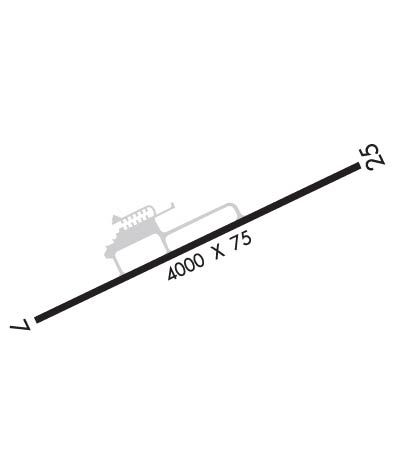
| Rwy | Rwy | |||||||
| 4000x75 | 4000' | 4000x75 | 4000' | |||||
| Runway ID | Single Wheel | Double Wheel | Double Tandem Wheel | Dual Double Wheel |
| 07/25 | 24,000 | N/A | N/A | N/A |
| These numbers are Advisory and are not limits. The Airport Manager should have more accurate Weight Limits | ||||
 Airport Diagram might not be current. | |
| Facility Name: | MASON COUNTY |
| City Name: | POINT PLEASANT |
| County: | MASON |
| State abbrev: | WV |
| State Name: | WEST VIRGINIA |
| Ownership: | PUBLICLY OWNED |
| Use: | OPEN TO THE PUBLIC |
| Owner's Name: | MASON CO COMISSION |
| Address: | COURT HOUSE 200 SIXTH ST |
| POINT PLEASANT, WV 25550 | |
| Owner's Phone: | 304-675-1110 |
| Manager's Name: | TRENT AND PAIGE ROUSH |
| Address: | 1518 AIRPORT RD |
| POINT PLEASANT, WV 25550 | |
| Phone: | 304-674-5075 |
| FAA Region: | EASTERN |
| FAA Field Office: | BKW |
| Date | Sunrise | Sunset |
|---|---|---|
| 04/17/24 Wednesday | 6:48 | 20:08 |
| 04/18/24 Thursday | 6:47 | 20:09 |
| 04/19/24 Friday | 6:45 | 20:10 |
| 04/20/24 Saturday | 6:44 | 20:11 |
| 04/21/24 Sunday | 6:42 | 20:12 |
| 04/22/24 Monday | 6:41 | 20:13 |
| 04/23/24 Tuesday | 6:40 | 20:14 |
| 04/24/24 Wednesday | 6:38 | 20:15 |
| 04/25/24 Thursday | 6:37 | 20:16 |
| 04/26/24 Friday | 6:36 | 20:17 |
| 04/27/24 Saturday | 6:35 | 20:18 |
| 04/28/24 Sunday | 6:33 | 20:19 |
| 04/29/24 Monday | 6:32 | 20:20 |
| 04/30/24 Tuesday | 6:31 | 20:21 |
| Airport Attendance Schedule | MON-FRI 1000-1400 |
| Airport Status | OPERATIONAL (This Status can change at any time - please check NOTAMS) |
| Airport Lighting Schedule | ACTVT REIL RWY 07 & 25; PAPI RWY 07 & 25; MIRL RWY 07/25 - CTAF. |
| Airport Storage Available | NONE |
| Extra Services Available | Flight Instruction, Aircraft Rental |
| Wind Indicator | YES - (lighted) |
| Control Tower | NO |
| CTAF Frequency | 122.800 |
| Unicom Frequency | 122.800 |
| Rotating Beacon Color | WG |
| Segmented Circle | YES |
| Landing Fee | NO |
| Airport Inspected | STATE - performed by PRIVATE CONTRACT PERSONNEL |
| Inspection Date | 07/06/2022 |
| Type of Fuel Available | Grade 100LL; -10SELF-SVC. |
| Airframe Repair Service | None |
| Power Plant Repair Service | None |
| Latitude | N3854.9 |
| Longitude | W08205.9 (ESTIMATED) |
| Arpt Elevation | 643ft (SURVEYED) |
| Magnetic Variation | 07W |
| 4 miles NE | of POINT PLEASANT |
| Traffic Pattern Altitude | |
| Sectional Chart | CINCINNATI |
| Operations (Reported) | Yearly | Avg. Daily |
|---|---|---|
| General Aviation Transient | 200 | 1 |
| General Aviation Local | 1500 | 4 |
| Air Taxi | 100 | 0 |
| Commerical | 0 | 0 |
| Commuter | 0 | 0 |
| Military | 10 | 0 |
| Aircraft based on Field | |
|---|---|
| General Aviation Singles | 9 |
| General Aviation Multi | 0 |
| Jet Aircraft | 0 |
| General Aviation Helicopters | 0 |
| Military Aircraft | 0 |
| Gliders | 0 |
| Ultralights | 1 |
| FSS on field | NO |
| FSS tie-in | ELKINS |
| FSS Phone | 1-800-WX-BRIEF |
| Who issues Notams | EKN |
| Notam D service at airport | YES |
| ARTCC Name | INDIANAPOLIS |
| Airport Certification | |
| Aircraft Rescue & Firefighting Index | None |
| Airport of Entry | No |
| Custom Landing Rights | No |
| Joint Civil/Military | No |
| Military Landing rights | YES |
| NATIONAL PLAN OF INTEGRATED AIRPORT SYSTEMS (NPIAS) |
| GRANT AGREEMENTS UNDER FAAP/ADAP/AIP |
| ASSURANCES PURSUANT TO TITLE VI, CIVIL RIGHTS ACT OF 1964 |
| DEER ON & INVOF ARPT. |
| COLD TEMPERATURE AIRPORT. ALTITUDE CORRECTION REQUIRED AT OR BELOW -17C. |
| FOR CD CTC HUNTINGTON ATCT AT 304-453-2490. |
| SEVERAL POWER PLANT STACKS IN VICINITY OF ARPT WEST & NORTH. |
| RWY 25, 35 FT DROP-OFF, 100 FT FM RWY END. |
| STEAM FROM COOLING TOWERS NW OCCASIONALLY OBSCURES OBSTN LGTS ON TOWER NORTH. |
| RWY 07 HAS 3 FT DITCH 80 FT L & R OF CNTRLN FIRST 1000 FT. |
| 6-8 FT BRUSH PARALLEL TO RWY 25, 100 FT FM CNTRLN, FM THR TO 1000 FT FM THR. |
| 6-8 FT BRUSH PARALLEL TO RWY 25, 95 FT FM CENTERLINE. |
Airport Communications & Frequencies:
| ||||||||||||||
| Runway: 07 | Runway: 25 | ||
| Mag heading: | 72° | Mag heading: | 252° |
| Rwy Slope: | -.34% Down | Rwy Slope: | .34% Up |
| Approach: | Approach: | ||
| Pattern: | Left Traffic | Pattern: | Left Traffic |
| Markings: | NONPRECISION INSTRUMENT | Markings: | NONPRECISION INSTRUMENT |
| Marking Condition: | GOOD | Marking Condition: | GOOD |
| Arresting Dev: | Arresting Dev: | ||
| Lat & Long: | N3854.7 W08206.3 | Lat. & Long.: | N3855.0 W08205.5 |
| Elev: | 639.0 ft. MSL | Elev: | 625.4 ft. MSL |
| TCH: | 44 ft. AGL | TCH: | 43 ft. AGL |
| Visual Glide Path: | 3.00 degrees | Visual Glide Path: | 3.00 degrees |
| Displaced Threshold: | No | Displaced Threshold: | No |
| Touchdown Zone: | YES | Touchdown Zone: | YES |
| Touchdown Elev.: | 643.4 feet | Touchdown Elev.: | 643.3 feet |
| Visual Glide Slope: | 2-Light PAPI on LEFT side of Runway | Visual Glide Slope: | 2-Light PAPI on LEFT side of Runway |
| RVR Equipment: | RVR Equipment: | ||
| RVV Equipment: | NO | RVV Equipment: | NO |
| Approach Lights: | Approach Lights: | ||
| REIL: | YES | REIL: | YES |
| Centerline Lights: | NO | Centerline Lights: | NO |
| Touchdown lights: | NO | Touchdown lights: | NO |
| Runway Category: | Runway with a Non-precision Approach | Runway Category: | Runway with a Non-precision Approach |
| Declared Distances: | Declared Distances: | ||
| Obstructions: | TREES | Obstructions: | TREES |
| Marked: | NOT Marked/Lighted | Marked: | NOT Marked/Lighted |
| Clearance slope: | 11:1 | Clearance slope: | 8:1 |
| Obstruction height: | 20 feet AGL | Obstruction height: | 15 feet AGL |
| Dist. from runway: | 420 feet | Dist. from runway: | 300 feet |
| Centerline offset: | 20 right of centerline; RWY 25 HAS 35 FT DROP-OFF 100 FT FM THR 0B. | Centerline offset: | |
| Comments: | 15 FT BRUSH. | Comments: | 20 FT BRUSH, 70-200 FT DSTC, 70 FT L. |
