Click here for more info on on SMS!

K3G3

WADSWORTH MUNI
WADSWORTH
OH
Time Zone: Eastern
Lat: N 4100.2
Long: W 08145.4
Elev: 974
Var: +07
Longest Runway: 3530
CTAF: 122.8

FBO & Flight Services info for K3G3

FBOs: Update your Fuel Prices

  click here  
Aviation fuel,aircraft parking(ramp or tiedown), rental cars, courtesy cars (free for pilots to use in the local area), pilots lounge / snooze room, public telephone, restrooms.
Ph: 330-334-9861
-
Freq: 122.8WebsiteE-Mail
                          
Service
Jet
100LL
SAF
MoGas
Fuel Avail: INJECTED PRIST INCLUDED IN PRICE. 24/7. Credit card accepted at pump.
Full        Last Update: 04/15/2024 12:09

Self6.105.99    
Misc. Info: Address: 840 AIRPORT DR.   WADSWORTH, OH 44281

If you are an FBO, call 1-203-262-1700 to update your info or email: FltPlan.Advertising@garmin.com
Advertise your FBO on FltPlan.com

Runway & Approach Info for K3G3
Rwy
Length
Land Dist**
Approach*
  Rwy
Length
Land Dist**
Approach*
02
3530x75  3400'          
 
  
20
  3530x75  3530'          
 
10
2155x35  2155'          
 
  
28
  2155x35  2155'          
 
 * only ILS, LOC, LDA, and SDF approaches to a specific runway are shown
** For any Declared Landing Distance Available, please see A/FD or Approach plates
Runway Weight Capability (lbs.) Help
Runway IDSingle WheelDouble WheelDouble Tandem WheelDual Double Wheel
02/20N/AN/AN/AN/A
10/28N/AN/AN/AN/A
These numbers are Advisory and are not limits.   The Airport Manager should have more accurate Weight Limits
Approach Charts
Approaches    
Current Weather/Notams
Customs Information Send updates to Support@FltPlan.com
Customs Not Available
Database effective 05/16/2024
Airport Diagram of K3G3
Airport Diagram might not be current.

Facility Name: WADSWORTH MUNI
City Name: WADSWORTH
County: MEDINA
State abbrev: OH
State Name: OHIO
   
Ownership: PUBLICLY OWNED
Use: OPEN TO THE PUBLIC
Owner's Name: CITY OF WADSWORTH ARPT COMMISSION
Address: WADSWORTH MUNICIPAL BLDG, 120 MAPLE ST
 WADSWORTH, OH 44281-1825
Owner's Phone: 330-335-1521
  
Manager's Name: MARK MILLER
Address: 840 AIRPORT DR
 WADSWORTH, OH 44281-9552
Phone: 330-334-9861; OR 330-241-2562.
   
FAA Region: GREAT LAKES
FAA Field Office: DET


Sunrise / Sunset times for WADSWORTH MUNI

DateSunriseSunset
04/23/24 Tuesday6:3520:16
04/24/24 Wednesday6:3320:17
04/25/24 Thursday6:3220:18
04/26/24 Friday6:3120:19
04/27/24 Saturday6:2920:20
04/28/24 Sunday6:2820:21
04/29/24 Monday6:2720:22
04/30/24 Tuesday6:2520:24
05/01/24 Wednesday6:2420:25
05/02/24 Thursday6:2320:26
05/03/24 Friday6:2220:27
05/04/24 Saturday6:2020:28
05/05/24 Sunday6:1920:29
05/06/24 Monday6:1820:30

Airport Facilities

Airport Attendance ScheduleCONTINUOUS
Airport Status OPERATIONAL (This Status can change at any time - please check NOTAMS)
Airport Lighting ScheduleACTVT MIRL RWY 02/20 - CTAF. VASI RWY 02 & 20 OPR CONSLY.
Airport Storage AvailableTie Downs, Hanger
Extra Services AvailableCharter, Glider, Flight Instruction, Aircraft Rental, Glider Towing
Wind IndicatorYES - (lighted)
Control TowerNO
CTAF Frequency122.800
Unicom Frequency122.800
Rotating Beacon ColorWG
Segmented CircleNO
Landing FeeNO

Airport Inspection Data

Airport InspectedSTATE - performed by STATE AERONAUTICAL PERSONNEL
Inspection Date10/15/2020

Airport Services

Type of Fuel AvailableGrade 100LL, JET A-1 (icing inhibitor, freeze point -50C)
Airframe Repair ServiceMAJOR
Power Plant Repair ServiceMAJOR

Geographic Data

LatitudeN4100.2
LongitudeW08145.4 (ESTIMATED)
Arpt Elevation973ft (SURVEYED)
Magnetic Variation07W
2 miles SWof WADSWORTH
Traffic Pattern Altitude
Sectional ChartDETROIT

Aircraft Data

Operations (Reported)YearlyAvg. Daily
General Aviation Transient 1200033
General Aviation Local 3000082
Air Taxi 5001
Commerical 00
Commuter 00
Military 500
Aircraft based on Field
General Aviation Singles 84
General Aviation Multi 6
Jet Aircraft 0
General Aviation Helicopters 1
Military Aircraft 0
Gliders 4
Ultralights 0

FAA Services

FSS on field NO
FSS tie-in CLEVELAND
FSS Phone 1-800-WX-BRIEF
Who issues Notams CLE
Notam D service at airport YES
ARTCC Name CLEVELAND

Federal Status

Airport Certification
Aircraft Rescue & Firefighting IndexNone
Airport of EntryNo
Custom Landing RightsNo
Joint Civil/MilitaryNo
Military Landing rightsNo

Federal Agreements

NATIONAL PLAN OF INTEGRATED AIRPORT SYSTEMS (NPIAS)

Remarks

CAUTION: EXTSV HEL OPS.
RWY 02 TFC PAT PREFERRED ENTRY AT 45 DEGS TO UPWIND LEG TO AVOID TFC AT 15G ARPT 2.5 NM NW.
RWY 10 CLSD FOR DEPARTURE WHEN WIND LESS THAN 15 KTS FM THE EAST.
NO LINE OF SIGHT BTN RWY'S 02 & 10.
RWY 20 CALM WIND RWY BLO 4 KTS FOR NOISE ABATEMENT. AVOID HOSPITAL TO THE N.
FOR CD CTC CLEVELAND APCH AT 216-352-2323, WHEN APCH CLSD CTC CLEVELAND ARTCC AT 440-774-0223.
TWY B CLSD TO PWRD ACFT
BIRDS, DEER, & OTR WILDLIFE ON & INVOF ARPT.
CAUTION: GLIDER OPS ALL RWY'S
Airport Communications & Frequencies:
CTAF Frequency:
122.800
Unicom Frequency:
122.800
Remarks
  • APCH/DEP SVC PRVDD BY CLEVELAND APCH (CLE) 0600-0100. APCH/DEP SVC PRVDD BY CLEVELAND ARTCC (ZOB) ON FREQS 134.9/269.475 (MANSFIELD RCAG) 0100-0600.
  • CLEVELAND Primary Approach Frequencies:  
    125.5
    371.875
    CLEVELAND Primary Departure Frequencies:  
    125.5
    371.875
    Runway Identifications
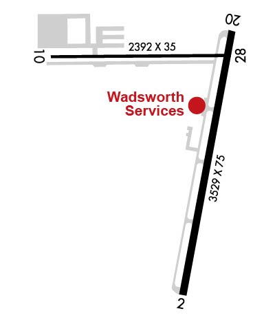
    Runway Identification: 02/20
    Length: 3530 ft
    Width: 75 ft
    Surface: ASPHALT-GOOD CONDITION
    Edge lights: Medium Intensity

    Treatment: NONE

     Runway: 02   Runway: 20
    Mag heading: 18°Mag heading: 198°
    Rwy Slope: .24% UpRwy Slope: -.24% Down
    Approach: Approach:
    Pattern: Left TrafficPattern: Left Traffic
    Markings: NONPRECISION INSTRUMENTMarkings: NONPRECISION INSTRUMENT
    Marking Condition: FAIRMarking Condition: FAIR
    Arresting Dev: Arresting Dev:
    Lat & Long: N4059.8  W08145.4Lat. & Long.: N4100.4  W08145.2
    Elev: 965.0 ft. MSLElev: 973.6 ft. MSL
    TCH: 24 ft. AGLTCH: 24 ft. AGL
    Visual Glide Path: 3.50 degreesVisual Glide Path: 3.50 degrees
    Displaced Threshold: 130 feetDisplaced Threshold: No
    Touchdown Zone: YESTouchdown Zone: YES
    Touchdown Elev.: 972.3 feetTouchdown Elev.: 973.7 feet
    Visual Glide Slope: 2-Box VASI on RIGHT side of RunwayVisual Glide Slope: 2-Box VASI on LEFT side of Runway
    RVR Equipment: RVR Equipment:
    RVV Equipment: NORVV Equipment: NO
    Approach Lights: Approach Lights:
    REIL: NOREIL: NO
    Centerline Lights: NOCenterline Lights: NO
    Touchdown lights: NOTouchdown lights: NO
    Runway Category: Runway with a Non-precision ApproachRunway Category: Runway with a Non-precision Approach
    Declared Distances: Declared Distances:
    Obstructions: FENCEObstructions: FENCE
    Marked: NOT Marked/LightedMarked: NOT Marked/Lighted
    Clearance slope: Clearance slope:
    Obstruction height: 4 feet AGLObstruction height: 4 feet AGL
    Dist. from runway: 201 feetDist. from runway: 201 feet
    Centerline offset: 175 right of centerlineCenterline offset: 233 feet left of centerline
    Comments: +4 FT FENCE, 0-200 FT DIST, 175-220 FT R, OBST CLNC SLP 0:1 TO DTHR.Comments: +4 FT FENCE, 85-200 FT DIST, 233-250 FT L, OBST CLNC SLP 0:1.
    Runway Identification: 10/28
    Length: 2155 ft
    Width: 35 ft
    Surface: ASPHALT
    Edge lights:

    Treatment: NONE

     Runway: 10   Runway: 28
    Mag heading: 97°Mag heading: 277°
    Rwy Slope: .39% UpRwy Slope: -.39% Down
    Approach: Approach:
    Pattern: Left TrafficPattern: Left Traffic
    Markings: BASICMarkings: BASIC
    Marking Condition: GOODMarking Condition: GOOD
    Arresting Dev: Arresting Dev:
    Lat & Long: N4100.3  W08145.8Lat. & Long.: N4100.3  W08145.3
    Elev: 962.8 ft. MSLElev: 971.1 ft. MSL
    TCH: TCH:
    Visual Glide Path: Visual Glide Path:
    Displaced Threshold: NoDisplaced Threshold: No
    Touchdown Zone: YESTouchdown Zone: YES
    Touchdown Elev.: 971.1 feetTouchdown Elev.: 971.1 feet
    Visual Glide Slope: Visual Glide Slope:
    RVR Equipment: RVR Equipment:
    RVV Equipment: NORVV Equipment: NO
    Approach Lights: Approach Lights:
    REIL: NOREIL: NO
    Centerline Lights: NOCenterline Lights: NO
    Touchdown lights: NOTouchdown lights: NO
    Runway Category: Runway with a Visual ApproachRunway Category: Runway with a Visual Approach
    Declared Distances: Declared Distances:
    Obstructions: POLEObstructions: TREE
    Marked: NOT Marked/LightedMarked: NOT Marked/Lighted
    Clearance slope: 2:1Clearance slope: 7:1
    Obstruction height: 31 feet AGLObstruction height: 90 feet AGL
    Dist. from runway: 281 feetDist. from runway: 859 feet
    Centerline offset: 125 right of centerlineCenterline offset: 158 feet left of centerline
    Comments: +20 FT TWY, 0-185 FT DIST, 100 FT L; +20 FT TWY, 0-85 FT DIST, 110 FT R.Comments:
    C:1/P: