Click here for more info on on SMS!

K3FK

FRANKLIN FLYING FIELD
FRANKLIN
IN
Time Zone: Eastern
Lat: N 3925.6
Long: W 08603.5
Elev: 740
Var: +02
Longest Runway: 2400
CTAF: 122.7

FBO & Flight Services info for K3FK

FBOs: Update your Fuel Prices
Providing high quality fuel and services to you and your customers from Phillips 66 Aviation.
Ph: 317-736-8359 Fax: 317-736-8549 Freq: 122.7WebsiteE-Mail
Service
Jet
100LL
SAF
MoGas
Fuel Avail: ~~ PILOTS CALL FOR FUEL PRICES
Full        Last Update: 04/19/2024 00:01:46

Self        
Misc. Info: Address: 3477 S 200 E   FRANKLIN, IN 46131

If you are an FBO, call 1-203-262-1700 to update your info or email: FltPlan.Advertising@garmin.com
Advertise your FBO on FltPlan.com

Runway & Approach Info for K3FK
Rwy
Length
Land Dist**
Approach*
  Rwy
Length
Land Dist**
Approach*
03
2400x35  2275'          
 
  
21
  2400x35  2235'          
 
 * only ILS, LOC, LDA, and SDF approaches to a specific runway are shown
** For any Declared Landing Distance Available, please see A/FD or Approach plates
Runway Weight Capability (lbs.) Help
Runway IDSingle WheelDouble WheelDouble Tandem WheelDual Double Wheel
03/21N/AN/AN/AN/A
These numbers are Advisory and are not limits.   The Airport Manager should have more accurate Weight Limits
Approach Charts
FltPlan does not have IFR approach charts available for K3FK.
Current Weather/Notams
Customs Information Send updates to Support@FltPlan.com
Customs Not Available
Database effective 04/18/2024
Airport Diagram of K3FK
Airport Diagram might not be current.

Facility Name: FRANKLIN FLYING FLD
City Name: FRANKLIN
County: JOHNSON
State abbrev: IN
State Name: INDIANA
   
Ownership: PRIVATELY OWNED
Use: OPEN TO THE PUBLIC
Owner's Name: SIBERB AVIATION CORP
Address: 3477 S. 200 E.
 FRANKLIN, IN 46131
Owner's Phone: 317-549-5273
  
Manager's Name: GEORGE ADAMS
Address: 3477 S. 200 E.
 FRANKLIN, IN 46131
Phone: 317-549-5273
   
FAA Region: GREAT LAKES
FAA Field Office: CHI


Sunrise / Sunset times for FRANKLIN FLYING FLD

DateSunriseSunset
04/18/24 Thursday7:0220:26
04/19/24 Friday7:0020:27
04/20/24 Saturday6:5920:28
04/21/24 Sunday6:5720:29
04/22/24 Monday6:5620:30
04/23/24 Tuesday6:5520:31
04/24/24 Wednesday6:5320:32
04/25/24 Thursday6:5220:33
04/26/24 Friday6:5120:34
04/27/24 Saturday6:4920:35
04/28/24 Sunday6:4820:36
04/29/24 Monday6:4720:37
04/30/24 Tuesday6:4620:38
05/01/24 Wednesday6:4420:39

Airport Facilities

Airport Attendance Schedule7 Days A Week IREG
Airport Status OPERATIONAL (This Status can change at any time - please check NOTAMS)
Airport Lighting Schedule
Airport Storage AvailableTie Downs, Hanger
Extra Services AvailableNONE
Wind IndicatorYES - (unlit)
Control TowerNO
CTAF Frequency122.700
Unicom Frequency122.700
Rotating Beacon Color
Segmented CircleNO
Landing FeeNO

Airport Inspection Data

Airport InspectedSTATE - performed by STATE AERONAUTICAL PERSONNEL
Inspection Date03/28/2023

Airport Services

Type of Fuel AvailableGrade 100LL
Airframe Repair ServiceNONE
Power Plant Repair ServiceNONE

Geographic Data

LatitudeN3925.6
LongitudeW08603.5 (ESTIMATED)
Arpt Elevation740ft (ESTIMATED)
Magnetic Variation02W
3 miles Sof FRANKLIN
Traffic Pattern Altitude
Sectional ChartST LOUIS

Aircraft Data

Operations (Reported)YearlyAvg. Daily
General Aviation Transient 00
General Aviation Local 00
Air Taxi 00
Commerical 00
Commuter 00
Military 00
Aircraft based on Field
General Aviation Singles 41
General Aviation Multi 1
Jet Aircraft 0
General Aviation Helicopters 1
Military Aircraft 0
Gliders 0
Ultralights 0

FAA Services

FSS on field NO
FSS tie-in TERRE HAUTE
FSS Phone 1-800-WX-BRIEF
Who issues Notams HUF
Notam D service at airport YES
ARTCC Name INDIANAPOLIS

Federal Status

Airport Certification
Aircraft Rescue & Firefighting IndexNone
Airport of EntryNo
Custom Landing RightsNo
Joint Civil/MilitaryNo
Military Landing rightsNo

Remarks

FOR CD CTC INDIANAPOLIS APCH AT 317-227-5743.
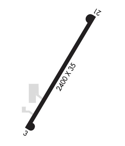
Runway Identifications
Runway Identification: 03/21
Length: 2400 ft
Width: 35 ft
Surface: ASPHALT-GOOD CONDITION
Edge lights:

Treatment: NONE

 Runway: 03   Runway: 21
Mag heading: N/AMag heading: N/A
Rwy Slope: -.58% DownRwy Slope: .58% Up
Approach: Approach:
Pattern: Left TrafficPattern: Left Traffic
Markings: Markings: NONSTANDARD
Marking Condition: Marking Condition: GOOD
Arresting Dev: Arresting Dev:
Lat & Long: N3925.4  W08603.7Lat. & Long.: N3925.8  W08603.4
Elev: 735.0 ft. MSLElev: 721.0 ft. MSL
TCH: TCH:
Visual Glide Path: Visual Glide Path:
Displaced Threshold: 125 feetDisplaced Threshold: 165 feet
Touchdown Zone: NOTouchdown Zone: NO
Touchdown Elev.: Touchdown Elev.:
Visual Glide Slope: Visual Glide Slope:
RVR Equipment: RVR Equipment:
RVV Equipment: NORVV Equipment: NO
Approach Lights: Approach Lights:
REIL: NOREIL: NO
Centerline Lights: NOCenterline Lights: NO
Touchdown lights: NOTouchdown lights: NO
Runway Category: Runway with a Visual ApproachRunway Category: Runway with a Visual Approach
Declared Distances: Declared Distances:
Obstructions: TREEObstructions: CROPS
Marked: NOT Marked/LightedMarked: NOT Marked/Lighted
Clearance slope: 13:1; APCH SLOPE TO DTHR 21:1.Clearance slope: APCH SLOPE TO DTHR 36:1.
Obstruction height: 40 feet AGLObstruction height: 10 feet AGL
Dist. from runway: 730 feetDist. from runway: 201 feet
Centerline offset: Centerline offset:
Comments: TREES 125 FT L OF CNTRLN 163 FT FM RWY END.Comments: CROPS 66 FT R OF CNTRLN & 113 FT L OF CNTRLN.
C:/P: