Click here for more info on on SMS!

K3D2

EPHRAIM-FISH CREEK
EPHRAIM
WI
Time Zone: Central
Lat: N 4508.1
Long: W 08711.3
Elev: 763
Var: +04
Longest Runway: 2697
AWOS: 124.17
CTAF: 123.0

FBO & Flight Services info for K3D2

FBOs: Update your Fuel Prices

EPHRAIM-GIBRALTARPh: 920-854-9711
-
Freq: 123.0
Service
Jet
100LL
SAF
MoGas
Fuel Avail: SELF SERV 24/7. Hrs 10a-3p
Full        Last Update: 04/09/2024 11:51

Self  6.59    
 Address: 9667 MAPLE GROVE RD   FISH CREEK, WI 54212
AWOSPh: 920-854-5559
-
Freq: 124.17  
If you are an FBO, call 1-203-262-1700 to update your info or email: FltPlan.Advertising@garmin.com
Advertise your FBO on FltPlan.com

Runway & Approach Info for K3D2
Rwy
Length
Land Dist**
Approach*
  Rwy
Length
Land Dist**
Approach*
01
2324x100  2324'          
 
  
19
  2324x100  2324'          
 
14
2697x60  2697'          
 
  
32
  2697x60  2697'          
 
 * only ILS, LOC, LDA, and SDF approaches to a specific runway are shown
** For any Declared Landing Distance Available, please see A/FD or Approach plates
Runway Weight Capability (lbs.) Help
Runway IDSingle WheelDouble WheelDouble Tandem WheelDual Double Wheel
01/19N/AN/AN/AN/A
14/3212,500N/AN/AN/A
These numbers are Advisory and are not limits.   The Airport Manager should have more accurate Weight Limits
Approach Charts
Approaches    
Current Weather/Notams
Customs Information Send updates to Support@FltPlan.com
Customs Not Available
Database effective 05/16/2024
Airport Diagram of K3D2
Airport Diagram might not be current.

Facility Name: EPHRAIM/GIBRALTAR
City Name: EPHRAIM
County: DOOR
State abbrev: WI
State Name: WISCONSIN
   
Ownership: PUBLICLY OWNED
Use: OPEN TO THE PUBLIC
Owner's Name: VILLAGE OF EPHRAIM; & TOWN OF GIBRALTAR.
Address: PO BOX 850
 FISH CREEK, WI 54212
Owner's Phone: 920-868-1714
  
Manager's Name: TRAVIS THYSSEN
Address: P O BOX 850
 FISH CREEK, WI 54212
Phone: 920-868-1714; ARPT OFC PHONE NR 920-854-3312, AVBL JUN-OCT, FRI-SUN.
   
FAA Region: GREAT LAKES
FAA Field Office: CHI


Sunrise / Sunset times for EPHRAIM/GIBRALTAR

DateSunriseSunset
04/25/24 Thursday5:4619:48
04/26/24 Friday5:4419:49
04/27/24 Saturday5:4319:51
04/28/24 Sunday5:4119:52
04/29/24 Monday5:4019:53
04/30/24 Tuesday5:3819:54
05/01/24 Wednesday5:3719:56
05/02/24 Thursday5:3519:57
05/03/24 Friday5:3419:58
05/04/24 Saturday5:3219:59
05/05/24 Sunday5:3120:01
05/06/24 Monday5:3020:02
05/07/24 Tuesday5:2820:03
05/08/24 Wednesday5:2720:04

Airport Facilities

Airport Attendance ScheduleJUN-OCT FRI 1500-1800, JUN-OCT SAT-SUN 1000-1700
Airport Status OPERATIONAL (This Status can change at any time - please check NOTAMS)
Airport Lighting ScheduleMIRL RWY 14/32 PRESET LOW SS-SR; INCR INTST AND ACTVT PAPI RWY 14 & 32 - CTAF.
Airport Storage AvailableTie Downs
Extra Services AvailableNONE
Wind IndicatorYES - (lighted)
Control TowerNO
CTAF Frequency123.000
Unicom Frequency123.000
Rotating Beacon ColorWG
Segmented CircleYES
Landing FeeNO

Airport Inspection Data

Airport InspectedSTATE - performed by STATE AERONAUTICAL PERSONNEL
Inspection Date08/16/2023

Airport Services

Type of Fuel AvailableGrade 100LL; -1024 HR SELF SVC FUEL AVBL WITH CREDIT CARD.
Airframe Repair ServiceNONE
Power Plant Repair ServiceNONE

Geographic Data

LatitudeN4508.1
LongitudeW08711.3 (ESTIMATED)
Arpt Elevation763ft (SURVEYED)
Magnetic Variation04W
1 miles SWof EPHRAIM
Traffic Pattern Altitude
Sectional ChartGREEN BAY

Aircraft Data

Operations (Reported)YearlyAvg. Daily
General Aviation Transient 550015
General Aviation Local 350010
Air Taxi 3001
Commerical 00
Commuter 00
Military 00
Aircraft based on Field
General Aviation Singles 18
General Aviation Multi 2
Jet Aircraft 0
General Aviation Helicopters 2
Military Aircraft 0
Gliders 0
Ultralights 0

FAA Services

FSS on field NO
FSS tie-in GREEN BAY
FSS Phone 1-800-WX-BRIEF
Who issues Notams GRB
Notam D service at airport YES
ARTCC Name MINNEAPOLIS

Federal Status

Airport Certification
Aircraft Rescue & Firefighting IndexNone
Airport of EntryNo
Custom Landing RightsNo
Joint Civil/MilitaryNo
Military Landing rightsYES

Federal Agreements

NATIONAL PLAN OF INTEGRATED AIRPORT SYSTEMS (NPIAS)
ASSURANCES PURSUANT TO TITLE VI, CIVIL RIGHTS ACT OF 1964
GRANT AGREEMENT HAS EXPIRED; HOWEVER, AGREEMENT REMAINS IN EFFECT FOR THIS FACILITY AS LONG AS IT IS PUBLIC USE.

Remarks

DEER NR MOVEMENT AREAS.
FOR CD CTC GREEN BAY APCH AT 920-431-5741, WHEN GREEN BAY APCH CLSD, FOR CD CTC MINNEAPOLIS ARTCC AT 651-463-5588.
RWY 01/1 9 SLOPES MDTELY DOWN TO SOUTH--CANNOT SEE ONE END FM THE OTHER.
Airport Communications & Frequencies:
CTAF Frequency:
123.000
Unicom Frequency:
123.000
Remarks
  • APCH/DEP SVC PRVDD BY MINNEAPOLIS ARTCC ON FREQ 127.65 (ESCANABA RCAG) WHEN GREEN BAY APCH CTL CLSD.
  • GREEN BAY Primary Approach Frequencies:  
    120.3
    338.2
    GREEN BAY Primary Departure Frequencies:  
    120.3
    338.2
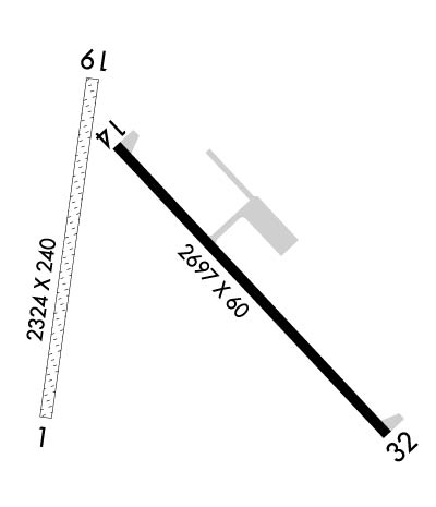
    Runway Identifications
    Runway Identification: 01/19
    Length: 2324 ft
    Width: 100 ft
    Surface: GRASS-FAIR CONDITION
    Edge lights:

    Treatment: NONE

     Runway: 01   Runway: 19
    Mag heading: 12°Mag heading: 192°
    Rwy Slope: .34% UpRwy Slope: -.34% Down
    Approach: Approach:
    Pattern: Left TrafficPattern: Left Traffic
    Markings: NONEMarkings: NONE
    Marking Condition: MKD WITH YELLOW CONES.Marking Condition: MKD WITH YELLOW CONES.
    Arresting Dev: Arresting Dev:
    Lat & Long: N4508.0  W08711.5Lat. & Long.: N4508.4  W08711.4
    Elev: 754.9 ft. MSLElev: 762.9 ft. MSL
    TCH: TCH:
    Visual Glide Path: Visual Glide Path:
    Displaced Threshold: NoDisplaced Threshold: No
    Touchdown Zone: YESTouchdown Zone: YES
    Touchdown Elev.: 762.9 feetTouchdown Elev.: 762.9 feet
    Visual Glide Slope: Visual Glide Slope:
    RVR Equipment: RVR Equipment:
    RVV Equipment: NORVV Equipment: NO
    Approach Lights: Approach Lights:
    REIL: NOREIL: NO
    Centerline Lights: NOCenterline Lights: NO
    Touchdown lights: NOTouchdown lights: NO
    Runway Category: Runway with a Visual ApproachRunway Category: Runway with a Visual Approach
    Declared Distances: Declared Distances:
    Runway Identification: 14/32
    Length: 2697 ft
    Width: 60 ft
    Surface: ASPHALT-GOOD CONDITION
    Edge lights: Medium Intensity

    Treatment: NONE

     Runway: 14   Runway: 32
    Mag heading: 140°Mag heading: 320°
    Rwy Slope: -.46% DownRwy Slope: .46% Up
    Approach: Approach:
    Pattern: Left TrafficPattern: Left Traffic
    Markings: NONPRECISION INSTRUMENTMarkings: NONPRECISION INSTRUMENT
    Marking Condition: FAIRMarking Condition: FAIR
    Arresting Dev: Arresting Dev:
    Lat & Long: N4508.3  W08711.4Lat. & Long.: N4508.0  W08710.9
    Elev: 763.2 ft. MSLElev: 750.9 ft. MSL
    TCH: 24 ft. AGLTCH: 25 ft. AGL
    Visual Glide Path: 3.50 degreesVisual Glide Path: 3.00 degrees
    Displaced Threshold: NoDisplaced Threshold: No
    Touchdown Zone: YESTouchdown Zone: YES
    Touchdown Elev.: 763.2 feetTouchdown Elev.: 763.2 feet
    Visual Glide Slope: 2-Light PAPI on LEFT side of RunwayVisual Glide Slope: 2-Light PAPI on LEFT side of Runway
    RVR Equipment: RVR Equipment:
    RVV Equipment: NORVV Equipment: NO
    Approach Lights: Approach Lights:
    REIL: NOREIL: NO
    Centerline Lights: NOCenterline Lights: NO
    Touchdown lights: NOTouchdown lights: NO
    Runway Category: Runway with a Non-precision ApproachRunway Category: Runway with a Non-precision Approach
    Declared Distances: Declared Distances:
    C:3/P: