Current Weather/Notams (Metars, TAFs, Notams, NWS Forecast, PIREPS, and nearby weather)
Customs Information Send updates to Support@FltPlan.com
Customs Not Available
Database effective 05/16/2024
Airport Diagram might not be current.
|
| Facility Name: | CABLE UNION |
| City Name: | CABLE |
| County: | BAYFIELD |
| State abbrev: | WI |
| State Name: | WISCONSIN |
| | |
| Ownership: | PUBLICLY OWNED |
| Use: | OPEN TO THE PUBLIC |
| Owner's Name: | TOWN OF CABLE; AND TOWN OF DRUMMOND & NAMEGAGON. |
| Address: | PO BOX 476 |
| | CABLE, WI 54821 |
| Owner's Phone: | 715-798-4440 |
| | |
| Manager's Name: | MIKE NICHOLS |
| Address: | 42905 TELEMARK RD, PO BOX 248 |
| | CABLE, WI 54821 |
| Phone: | 715-798-3240 |
| | |
| FAA Region: | GREAT LAKES |
| FAA Field Office: | CHI |
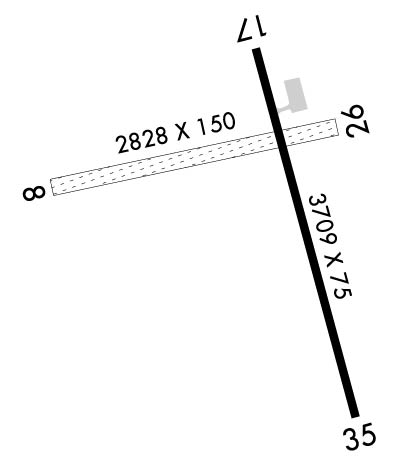
Runway Identifications
Runway Identification: 08/26Length: 2194 ft
Width: 150 ft
Surface: GRASS-GOOD CONDITION
Edge lights: Treatment: NONE
| | Runway: 08 | | Runway: 26 |
| Mag heading: | 80° | Mag heading: | 260° |
| Rwy Slope: | .00% | Rwy Slope: | .00% |
| Approach: | | Approach: | |
| Pattern: | Left Traffic | Pattern: | Left Traffic |
| Markings: | NONE | Markings: | NONE |
| Marking Condition: | FAIR; RWY 08/26 MKD WITH YELLOW CONES. | Marking Condition: | FAIR |
| Arresting Dev: | | Arresting Dev: | |
| Lat & Long: | N4611.7 W09115.4 | Lat. & Long.: | N4611.8 W09114.9 |
| Elev: | 1344.0 ft. MSL | Elev: | 1344.0 ft. MSL |
| TCH: | | TCH: | |
| Visual Glide Path: | | Visual Glide Path: | |
| Displaced Threshold: | 378 feet | Displaced Threshold: | No |
| Touchdown Zone: | YES | Touchdown Zone: | YES |
| Touchdown Elev.: | 1344.0 feet | Touchdown Elev.: | 1344.0 feet |
| Visual Glide Slope: | | Visual Glide Slope: | |
| RVR Equipment: | | RVR Equipment: | |
| RVV Equipment: | NO | RVV Equipment: | NO |
| Approach Lights: | | Approach Lights: | |
| REIL: | NO | REIL: | NO |
| Centerline Lights: | NO | Centerline Lights: | NO |
| Touchdown lights: | NO | Touchdown lights: | NO |
| Runway Category: | Runway with a Visual Approach | Runway Category: | Runway with a Visual Approach |
| Declared Distances: | | Declared Distances: | |
| Obstructions: | TREES | Obstructions: | |
| Marked: | NOT Marked/Lighted | Marked: | |
| Clearance slope: | 10:1; APCH RATIO 18:1 TO DSPLCD THR; 60 FT TREES 1023 FT FM DSPCLD THR, ON CNTRLN. | Clearance slope: | 20:1 |
| Obstruction height: | 60 feet AGL | Obstruction height: | |
| Dist. from runway: | 645 feet | Dist. from runway: | |
| Centerline offset: | | Centerline offset: | |
| Comments: | | Comments: | |
Runway Identification: 17/35Length: 3709 ft
Width: 75 ft
Surface: ASPHALT-FAIR CONDITION
Edge lights: Medium IntensityTreatment: NONE
| | Runway: 17 | | Runway: 35 |
| Mag heading: | 167° | Mag heading: | 347° |
| Rwy Slope: | .35% Up | Rwy Slope: | -.35% Down |
| Approach: | | Approach: | |
| Pattern: | Left Traffic | Pattern: | Left Traffic |
| Markings: | NONPRECISION INSTRUMENT | Markings: | NONPRECISION INSTRUMENT |
| Marking Condition: | GOOD | Marking Condition: | GOOD |
| Arresting Dev: | | Arresting Dev: | |
| Lat & Long: | N4611.9 W09114.9 | Lat. & Long.: | N4611.4 W09114.7 |
| Elev: | 1347.1 ft. MSL | Elev: | 1360.2 ft. MSL |
| TCH: | | TCH: | |
| Visual Glide Path: | | Visual Glide Path: | |
| Displaced Threshold: | 191 feet | Displaced Threshold: | 563 feet |
| Touchdown Zone: | YES | Touchdown Zone: | YES |
| Touchdown Elev.: | 1357.7 feet | Touchdown Elev.: | 1357.2 feet |
| Visual Glide Slope: | | Visual Glide Slope: | |
| RVR Equipment: | | RVR Equipment: | |
| RVV Equipment: | NO | RVV Equipment: | NO |
| Approach Lights: | | Approach Lights: | |
| REIL: | NO | REIL: | NO |
| Centerline Lights: | NO | Centerline Lights: | NO |
| Touchdown lights: | NO | Touchdown lights: | NO |
| Runway Category: | Runway with a Visual Approach | Runway Category: | Runway with a Non-precision Approach |
| Declared Distances: | TORA:3709' TODA:3709' ASDA:3709' LDA:3519' | Declared Distances: | TORA:3709' TODA:3709' ASDA:3709' LDA:3146' |
| Obstructions: | TREES | Obstructions: | TREES |
| Marked: | NOT Marked/Lighted | Marked: | NOT Marked/Lighted |
| Clearance slope: | 1:1; APCH RATIO 12:1 TO DSPLCD THR; 35 FT TREES 420 FT FM DSPCLD THR, 220 FT R. | Clearance slope: | 9:1; RWY 35 APCH RATIO 16:1 TO DSPLCD THLD. |
| Obstruction height: | 35 feet AGL | Obstruction height: | 189 feet AGL |
| Dist. from runway: | 240 feet | Dist. from runway: | 1900 feet |
| Centerline offset: | 220 right of centerline | Centerline offset: | 400 feet left of centerline |
| Comments: | | Comments: | 30 FT TREES 180 FT FM RWY END, 240 FT L. |

